


$2,500
/ Month
421 N Chestnut St
Lansdale, PA 19446
Today
|
Edit
Favorites
215-738-6284
-
Bedrooms
3
-
Bathrooms
1.5
-
Square Feet
--
-
Available
Available Dec 26
Highlight
- Basement
421 N Chestnut St

Favorites
About This Home
Available Dec 26
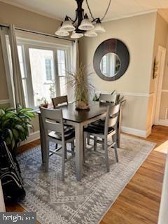
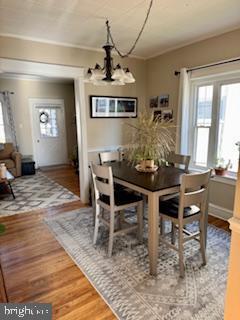
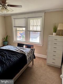
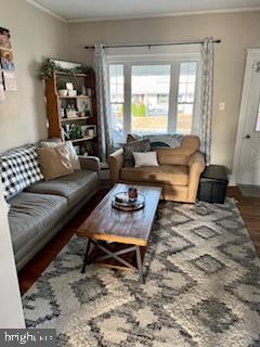
Charming 3Br 1.1 B Twin w/ Hardwood flooring, newer Central Air and Gas Heat. Full basement for additional storage . Nice backyard with off street parking. Property comes equipped with a washer, dryer, and refrigerator. Landlord pays for water and sewer. Tenant responsible for Electric, gas, snow removal, grass cutting.
421 N Chestnut St is a house located in Montgomery County and the 19446 ZIP Code. This area is served by the North Penn attendance zone.
* Price shown is base rent. Excludes user-selected optional fees and variable or usage-based fees and required charges due at or prior to move-in or at move-out. Price, availability, fees, and any applicable rent special are subject to change without notice.
* Square footage definitions vary. Displayed square footage is approximate.
House Features
- Dishwasher
- Basement
Contact
- Listed by Neil H Soffer | Long & Foster Real Estate, Inc.
- Phone Number
- Contact
-
Source
 Bright MLS, Inc.
Copyright © 2025 Bright MLS, Inc.
Location
Get Directions
Amenities
- Dishwasher
- Basement
Nestled in the heart of the North Penn Valley, Lansdale is a small Montgomery County borough situated about 28 miles north of Philadelphia. Residents have easy access to the city via SEPTA’s Doylestown line. Primarily a residential area, Lansdale features residential neighborhoods with an array of amenity-laden apartments for rent.
Lansdale is home to a growing downtown corridor filled with specialty shops and a variety of restaurants. An increasingly diverse population has led to a rise in assorted markets and eateries in Lansdale. Residents of Lansdale have the opportunity to visit Merrymead Farm, drink what’s on tap at Round Guys Brewing Company, have a cup of joe at Backyard Beans Coffee Company, peruse the comic books at the Comic Archive, attend a wide range of community events and festivals, and so much more in this thriving city.
Learn more about living in Lansdale
Education
| Colleges & Universities | Distance | ||
|---|---|---|---|
| Colleges & Universities | Distance | ||
| Drive: | 13 min | 4.6 mi | |
| Drive: | 14 min | 6.9 mi | |
| Drive: | 17 min | 8.3 mi | |
| Drive: | 20 min | 9.7 mi |
421 N Chestnut St is within 13 minutes or 4.6 miles from Gwynedd Mercy College. It is also near Montgomery Co. C.C., Central and Temple University, Ambler.
Schools


Public Elementary School
Grades K-6
602 Students
Attendance Zone
Public Elementary School
Grades K-5
707 Students
Nearby
Public Middle School
Grades 7-9
1,208 Students
Attendance Zone
Public High School
Grades 10-12
3,184 Students
Attendance Zone
Private Elementary & Middle School
Grades PK-8
507 Students
Nearby
Private High School
Grades 9-12
641 Students
Nearby
School data provided by
 The GreatSchools Rating helps parents compare schools within a state based on a variety of school quality indicators and provides a helpful picture of how effectively each school serves all of its students. Ratings are on a scale of 1 (below average) to 10 (above average) and can include test scores, college readiness, academic progress, advanced courses, equity, discipline and attendance data. We also advise parents to visit schools, consider other information on school performance and programs, and consider family needs as part of the school selection process.
View GreatSchools Rating Methodology
Data provided by GreatSchools.org © 2025. All rights reserved.
View GreatSchools Rating Methodology
Data provided by GreatSchools.org © 2025. All rights reserved.
Transportation options available in Lansdale include Norristown Transportation Center (100 Line), located 12.5 miles from 421 N Chestnut St. 421 N Chestnut St is near Trenton Mercer, located 36.6 miles or 58 minutes away, and Philadelphia International, located 37.6 miles or 55 minutes away.
| Transit / Subway | Distance | ||
|---|---|---|---|
| Transit / Subway | Distance | ||
|
|
Drive: | 26 min | 12.5 mi |
| Commuter Rail | Distance | ||
|---|---|---|---|
| Commuter Rail | Distance | ||
|
|
Walk: | 10 min | 0.5 mi |
| Walk: | 13 min | 0.7 mi | |
|
|
Drive: | 3 min | 1.3 mi |
|
|
Drive: | 3 min | 1.6 mi |
|
|
Drive: | 6 min | 2.9 mi |
| Airports | Distance | ||
|---|---|---|---|
| Airports | Distance | ||
|
Trenton Mercer
|
Drive: | 58 min | 36.6 mi |
|
Philadelphia International
|
Drive: | 55 min | 37.6 mi |
Time and distance from 421 N Chestnut St.
| Shopping Centers | Distance | ||
|---|---|---|---|
| Shopping Centers | Distance | ||
| Walk: | 17 min | 0.9 mi | |
| Walk: | 19 min | 1.0 mi | |
| Walk: | 19 min | 1.0 mi |
421 N Chestnut St has 3 shopping centers within 1.0 miles, which is about a 19-minute walk. The miles and minutes will be for the farthest away property.
| Parks and Recreation | Distance | ||
|---|---|---|---|
| Parks and Recreation | Distance | ||
|
Gwynedd Wildlife Preserve
|
Drive: | 12 min | 5.6 mi |
|
Norristown Farm Park
|
Drive: | 17 min | 8.7 mi |
|
Henry Schmieder Arboretum
|
Drive: | 18 min | 9.1 mi |
|
Peace Valley Park
|
Drive: | 20 min | 9.2 mi |
|
Evansburg State Park
|
Drive: | 25 min | 12.6 mi |
421 N Chestnut St has 5 parks within 12.6 miles, including Gwynedd Wildlife Preserve, Norristown Farm Park, and Peace Valley Park.
| Hospitals | Distance | ||
|---|---|---|---|
| Hospitals | Distance | ||
| Walk: | 18 min | 1.0 mi | |
| Drive: | 14 min | 6.7 mi | |
| Drive: | 18 min | 9.2 mi |
421 N Chestnut St has 3 hospitals within 9.2 miles, the nearest is Abington Health Lansdale Hospital which is 1.0 mile away and a 18 minute walk.
| Military Bases | Distance | ||
|---|---|---|---|
| Military Bases | Distance | ||
| Drive: | 21 min | 11.0 mi | |
| Drive: | 29 min | 15.4 mi |
421 N Chestnut St is 11.0 miles from Willow Grove Naval Air Station, and is convenient to other military bases, including Naval Air Development Center.
You May Also Like
Similar Rentals Nearby


What Are Walk Score®, Transit Score®, and Bike Score® Ratings?
Walk Score® measures the walkability of any address. Transit Score® measures access to public transit. Bike Score® measures the bikeability of any address.
What is a Sound Score Rating?
A Sound Score Rating aggregates noise caused by vehicle traffic, airplane traffic and local sources
421 N Chestnut St
Lansdale, PA 19446