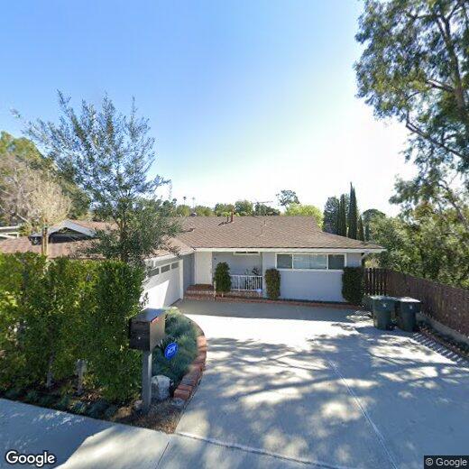
420 Tamarac Dr
Pasadena, CA 91105
-
Bedrooms
4
-
Bathrooms
3
-
Square Feet
2,570 sq ft
Highlight
- Pets Allowed

About This Home
Property Id: 2406133 This inviting residence features generous square footage across two stories, with four well sized bedrooms and three full bathrooms ideal for households seeking comfort, privacy, and flexibility. Large windows throughout the home bring in abundant natural light, while two gas fireplaces add warmth and charm. The living room, family room, and two balconies provide multiple areas for relaxing or entertaining, each offering scenic views of the San Rafael Hills. Step outside to a fully fenced private backyard with terraced levels perfect for outdoor dining, play, or gardening. An outdoor BBQ setup enhances your ability to entertain or unwind in your own peaceful retreat. Contact us today to schedule a private tour.
420 Tamarac Dr is a house located in Los Angeles County and the 91105 ZIP Code. This area is served by the Pasadena Unified attendance zone.
Fees and Policies
The fees listed below are community-provided and may exclude utilities or add-ons. All payments are made directly to the property and are non-refundable unless otherwise specified. Use the Cost Calculator to determine costs based on your needs.
-
One-Time Basics
-
Due at Move-In
-
Security Deposit - RefundableCharged per unit.$9,200
-
-
Due at Move-In
-
Dogs
-
Allowed
-
-
Cats
-
Allowed
-
-
Garage Lot
Property Fee Disclaimer: Based on community-supplied data and independent market research. Subject to change without notice. May exclude fees for mandatory or optional services and usage-based utilities.
Details
Utilities Included
-
Trash Removal
-
Sewer
Contact
-
Source

Annandale is nestled in a quaint, high-end section of Pasadena in the outskirts of Los Angeles. Many visitors pass through Annandale to cross the landmark Colorado Street Bridge or exit the Ventura Freeway heading to events at the Rose Bowl. The neighborhood contains mostly million-dollar homes and grand estates, along with a few upscale rental properties. The only commercial zone rests along Colorado Boulevard, comprising of a few small businesses. The Arroyo Seco defines the eastern border, a dry riverbed that extends from the San Gabriel Mountains down to Elysian Park. Annandale sits only two miles west of Pasadena City Hall and nine miles northeast of Downtown Los Angeles.
Learn more about living in Annandale| Colleges & Universities | Distance | ||
|---|---|---|---|
| Colleges & Universities | Distance | ||
| Drive: | 8 min | 2.9 mi | |
| Drive: | 8 min | 3.0 mi | |
| Drive: | 7 min | 3.3 mi | |
| Drive: | 10 min | 3.9 mi |


View GreatSchools Rating Methodology
Data provided by GreatSchools.org © 2026. All rights reserved.
Transportation options available in Pasadena include Fillmore Station, located 2.5 miles from 420 Tamarac Dr. 420 Tamarac Dr is near Bob Hope, located 15.1 miles or 22 minutes away, and Los Angeles International, located 25.9 miles or 37 minutes away.
| Transit / Subway | Distance | ||
|---|---|---|---|
| Transit / Subway | Distance | ||
|
|
Drive: | 7 min | 2.5 mi |
|
|
Drive: | 6 min | 2.5 mi |
|
|
Drive: | 6 min | 2.6 mi |
|
|
Drive: | 6 min | 2.7 mi |
|
|
Drive: | 7 min | 2.8 mi |
| Commuter Rail | Distance | ||
|---|---|---|---|
| Commuter Rail | Distance | ||
|
|
Drive: | 11 min | 7.6 mi |
|
|
Drive: | 14 min | 7.6 mi |
|
|
Drive: | 16 min | 7.7 mi |
|
|
Drive: | 15 min | 9.7 mi |
| Drive: | 18 min | 11.7 mi |
| Airports | Distance | ||
|---|---|---|---|
| Airports | Distance | ||
|
Bob Hope
|
Drive: | 22 min | 15.1 mi |
|
Los Angeles International
|
Drive: | 37 min | 25.9 mi |
Time and distance from 420 Tamarac Dr.
| Shopping Centers | Distance | ||
|---|---|---|---|
| Shopping Centers | Distance | ||
| Drive: | 3 min | 1.3 mi | |
| Drive: | 3 min | 1.5 mi | |
| Drive: | 5 min | 2.0 mi |
| Parks and Recreation | Distance | ||
|---|---|---|---|
| Parks and Recreation | Distance | ||
|
Kidspace Children's Museum
|
Drive: | 6 min | 2.4 mi |
|
Audubon Center at Debs Park
|
Drive: | 8 min | 3.7 mi |
|
Jet Propulsion Laboratory
|
Drive: | 9 min | 5.1 mi |
|
Elyria Canyon Park
|
Drive: | 13 min | 5.4 mi |
|
Huntington Botanical Gardens
|
Drive: | 13 min | 5.6 mi |
| Hospitals | Distance | ||
|---|---|---|---|
| Hospitals | Distance | ||
| Drive: | 5 min | 2.1 mi | |
| Drive: | 8 min | 4.2 mi | |
| Drive: | 12 min | 5.1 mi |
| Military Bases | Distance | ||
|---|---|---|---|
| Military Bases | Distance | ||
| Drive: | 34 min | 24.2 mi | |
| Drive: | 47 min | 31.7 mi |
You May Also Like
What Are Walk Score®, Transit Score®, and Bike Score® Ratings?
Walk Score® measures the walkability of any address. Transit Score® measures access to public transit. Bike Score® measures the bikeability of any address.
What is a Sound Score Rating?
A Sound Score Rating aggregates noise caused by vehicle traffic, airplane traffic and local sources

420 Tamarac Dr
Pasadena, CA 91105