
$9,700
Total Monthly Price
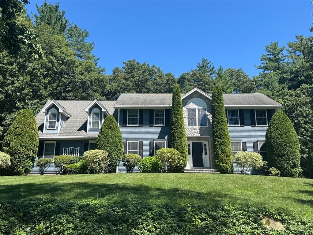
42 Willard Rd
Weston, MA 02493
Today
|
Edit
Favorites
781-365-9954
-
Bedrooms
4
-
Bathrooms
3.5
-
Square Feet
4,959 sq ft
-
Available
Available Now
Highlights
- Golf Course Community
- Media Room
- Open Floorplan
- Landscaped Professionally
- Property is near public transit and schools
- Marble Flooring
42 Willard Rd

Favorites
About This Home
$9,700 deposit,
Available Now
Beautifully updated 4 bedroom,3.5 bath colonial in Weston available for rent. Features include a grand two-story foyer,new oak floors,family room with gas fireplace and a modern kitchen with white cabinetry,quartz countertops and stainless steel appliances. Enjoy a sunroom,private office,formal dining room and finished lower level with full bath,exercise,media and play areas. Landscaped backyard with patio,built-in grill,fire pit and garden shed. Located in a private neighborhood within top-rated Weston school district. Home is available partially furnished. Please reach out for more photos of those spaces. Small pets are negotiable. MLS# 73450793
42 Willard Rd is a house located in Middlesex County and the 02493 ZIP Code. This area is served by the Weston attendance zone.
* Price shown is total price based on community-supplied monthly required fees. Excludes user-selected optional fees and variable or usage-based fees and required charges due at or prior to move-in or at move-out. Price, availability, fees, and any applicable rent special are subject to change without notice.
* Square footage definitions vary. Displayed square footage is approximate.
Home Details
Home Type
Single Family Detached Home
Bedrooms and Bathrooms
Soaking Tub
Double Vanity
Walk-In Closet
Primary bedroom located on second floor
3.5 Bathrooms
4 Bedrooms
Eco-Friendly Details
Integrated Pest Management
Flooring
Marble
Wood
Ceramic Tile
Carpet
Home Design
Updated or Remodeled
Entry on the 3rd floor
Home Security
Home Security System
Interior Spaces
Media Room
Open Floorplan
Family Room with Fireplace
Cathedral Ceiling
Sun or Florida Room
Mud Room
Home Office
Home Gym
Play Room
Wainscoting
Recessed Lighting
French Doors
4,959 Sq Ft Home
Kitchen
Upgraded Countertops
Stainless Steel Appliances
Breakfast Bar
Kitchen Island
Laundry
Laundry on upper level
Washer and Electric Dryer Hookup
Listing and Financial Details
Security Deposit $9,700
Property Available on 11/15/25
12 Month Lease Term
Assessor Parcel Number 866726
Rent includes gardener, furnishings (see remarks)
Location
Property is near public transit and schools
Lot Details
Landscaped Professionally
Outdoor Features
Patio
Parking
3 Car Garage
Utilities
No Cooling
Heating System Uses Oil
Community Details
Amenities
Shops
Laundry Facilities
Overview
Near Conservation Area
No Home Owners Association
Pet Policy
Call for details about the types of pets allowed
Recreation
Golf Course Community
Community Pool
Tennis Courts
Jogging Path
Bike Trail
Fees and Policies
The fees listed below are community-provided and may exclude utilities or add-ons. All payments are made directly to the property and are non-refundable unless otherwise specified. Use the Cost Calculator to determine costs based on your needs.
-
One-Time Basics
-
Due at Move-In
-
Security Deposit - RefundableCharged per unit.$9,700
-
-
Due at Move-In
Property Fee Disclaimer: Based on community-supplied data and independent market research. Subject to change without notice. May exclude fees for mandatory or optional services and usage-based utilities.
Contact
- Listed by Donahue Maley and Burns Team | Compass
- Phone Number
-
Source
 MLS Property Information Network
The property listing data and information set forth herein were provided to MLS Property Information Network, Inc. from third party sources, including sellers, lessors and public records, and were compiled by MLS Property Information Network, Inc. The property listing data and information are for the personal, non-commercial use of consumers having a good faith interest in purchasing or leasing listed properties of the type displayed to them and may not be used for any purpose other than to identify prospective properties which such consumers may have a good faith interest in purchasing or leasing. MLS Property Information Network, Inc. and its subscribers disclaim any and all representations and warranties as to the accuracy of the property listing data and information set forth herein. All properties are subject to prior sale, change or withdrawal. Copyright © 2026 MLS Property Information Network, Inc. All rights reserved.
Location
Get Directions
Just west of Boston and East of Worcester sits Metro West, a region that houses a group of towns and cities with significant historical backgrounds. A total of 19 municipalities make up the core of this community, but other municipalities are considered to be a part of the Interstate 495/Metro West Corridor.
Learn more about living in Metro West
Amenities
- Patio
Education
| Colleges & Universities | Distance | ||
|---|---|---|---|
| Colleges & Universities | Distance | ||
| Drive: | 12 min | 5.5 mi | |
| Drive: | 13 min | 6.5 mi | |
| Drive: | 22 min | 9.5 mi | |
| Drive: | 21 min | 11.1 mi |
42 Willard Rd is within 12 minutes or 5.5 miles from Brandeis University. It is also near Bentley University and Wellesley College.
Schools


Public Elementary School
Grades 4-5
266 Students
Nearby
Public Elementary School
Grades PK-3
320 Students
Attendance Zone
Public Elementary School
Grades PK-3
331 Students
Attendance Zone
Public Middle School
Grades 6-8
444 Students
Attendance Zone
Public High School
Grades 9-12
639 Students
Attendance Zone
Private Elementary School
Grades PK-6
Nearby
Private Elementary & Middle School
Grades K-8
Nearby
Private Elementary, Middle & High School
Grades 3-12
73 Students
Nearby
Private Elementary, Middle & High School
Grades 3-12
107 Students
Nearby
Private High School
Grades 9-12
329 Students
Nearby
School data provided by
 The GreatSchools Rating helps parents compare schools within a state based on a variety of school quality indicators and provides a helpful picture of how effectively each school serves all of its students. Ratings are on a scale of 1 (below average) to 10 (above average) and can include test scores, college readiness, academic progress, advanced courses, equity, discipline and attendance data. We also advise parents to visit schools, consider other information on school performance and programs, and consider family needs as part of the school selection process.
View GreatSchools Rating Methodology
Data provided by GreatSchools.org © 2026. All rights reserved.
View GreatSchools Rating Methodology
Data provided by GreatSchools.org © 2026. All rights reserved.
Transportation options available in Weston include Riverside Station, located 7.8 miles from 42 Willard Rd. 42 Willard Rd is near General Edward Lawrence Logan International, located 18.8 miles or 34 minutes away, and Worcester Regional, located 37.7 miles or 62 minutes away.
| Transit / Subway | Distance | ||
|---|---|---|---|
| Transit / Subway | Distance | ||
|
|
Drive: | 15 min | 7.8 mi |
|
|
Drive: | 15 min | 8.2 mi |
|
|
Drive: | 16 min | 8.9 mi |
|
|
Drive: | 18 min | 10.4 mi |
|
|
Drive: | 19 min | 10.7 mi |
| Commuter Rail | Distance | ||
|---|---|---|---|
| Commuter Rail | Distance | ||
| Walk: | 9 min | 0.5 mi | |
|
|
Drive: | 5 min | 2.6 mi |
|
|
Drive: | 6 min | 3.0 mi |
| Drive: | 10 min | 5.1 mi | |
|
|
Drive: | 11 min | 5.4 mi |
| Airports | Distance | ||
|---|---|---|---|
| Airports | Distance | ||
|
General Edward Lawrence Logan International
|
Drive: | 34 min | 18.8 mi |
|
Worcester Regional
|
Drive: | 62 min | 37.7 mi |
Time and distance from 42 Willard Rd.
| Shopping Centers | Distance | ||
|---|---|---|---|
| Shopping Centers | Distance | ||
| Drive: | 6 min | 3.0 mi | |
| Drive: | 9 min | 4.0 mi | |
| Drive: | 11 min | 4.6 mi |
42 Willard Rd has 3 shopping centers within 4.6 miles, which is about a 11-minute drive. The miles and minutes will be for the farthest away property.
| Parks and Recreation | Distance | ||
|---|---|---|---|
| Parks and Recreation | Distance | ||
|
Mass Audubon's Drumlin Farm Wildlife Sanctuary
|
Drive: | 5 min | 2.7 mi |
|
Codman Community Farms
|
Drive: | 6 min | 2.9 mi |
|
Land's Sake Farm
|
Drive: | 8 min | 3.1 mi |
|
Hazel Brook Conservation Area
|
Drive: | 9 min | 3.5 mi |
|
Upper Mill Brook Conservation Area
|
Drive: | 11 min | 5.3 mi |
42 Willard Rd has 5 parks within 5.3 miles, including Mass Audubon's Drumlin Farm Wildlife Sanctuary, Codman Community Farms, and Land's Sake Farm.
| Hospitals | Distance | ||
|---|---|---|---|
| Hospitals | Distance | ||
| Drive: | 10 min | 4.8 mi | |
| Drive: | 15 min | 7.8 mi | |
| Drive: | 14 min | 7.9 mi |
42 Willard Rd has 3 hospitals within 7.9 miles, the nearest is Walden Behavioral Care which is 4.8 miles away and a 10 minute drive.
| Military Bases | Distance | ||
|---|---|---|---|
| Military Bases | Distance | ||
| Drive: | 17 min | 8.1 mi | |
| Drive: | 19 min | 9.8 mi |
42 Willard Rd is 8.1 miles from Hanscom Air Force Base, and is convenient to other military bases, including US Military Reservation.
You May Also Like
Similar Rentals Nearby
-
-

-

-

-

-

-
 6 Beds, 5 Baths, 4,000 sq ft$6,000Total Monthly PriceTotal Monthly Price NewPrices include all required monthly fees.8 Brandley Rd
 -
 4 Beds, 3 Baths, 2,970 sq ft$5,200Total Monthly Price12 Month LeaseTotal Monthly Price NewPrices include all required monthly fees.606 Springs Rd
 -
 7 Beds, 3 Baths, 3,428 sq ft$9,999Total Monthly PriceTotal Monthly Price NewPrices include all required monthly fees.12 Naples Rd
 -
 4 Beds, 3 Baths, 1,750 sq ft$4,900Total Monthly PriceTotal Monthly Price NewPrices include all required monthly fees.20 Sheridan Ave
What Are Walk Score®, Transit Score®, and Bike Score® Ratings?
Walk Score® measures the walkability of any address. Transit Score® measures access to public transit. Bike Score® measures the bikeability of any address.
What is a Sound Score Rating?
A Sound Score Rating aggregates noise caused by vehicle traffic, airplane traffic and local sources

42 Willard Rd
Weston, MA 02493