$1,950
Total Monthly Price
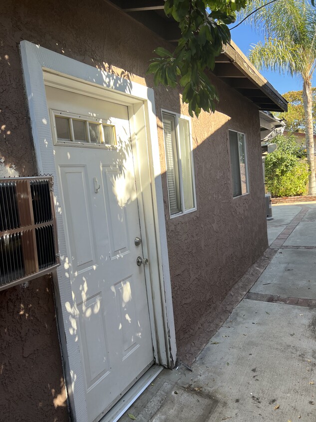
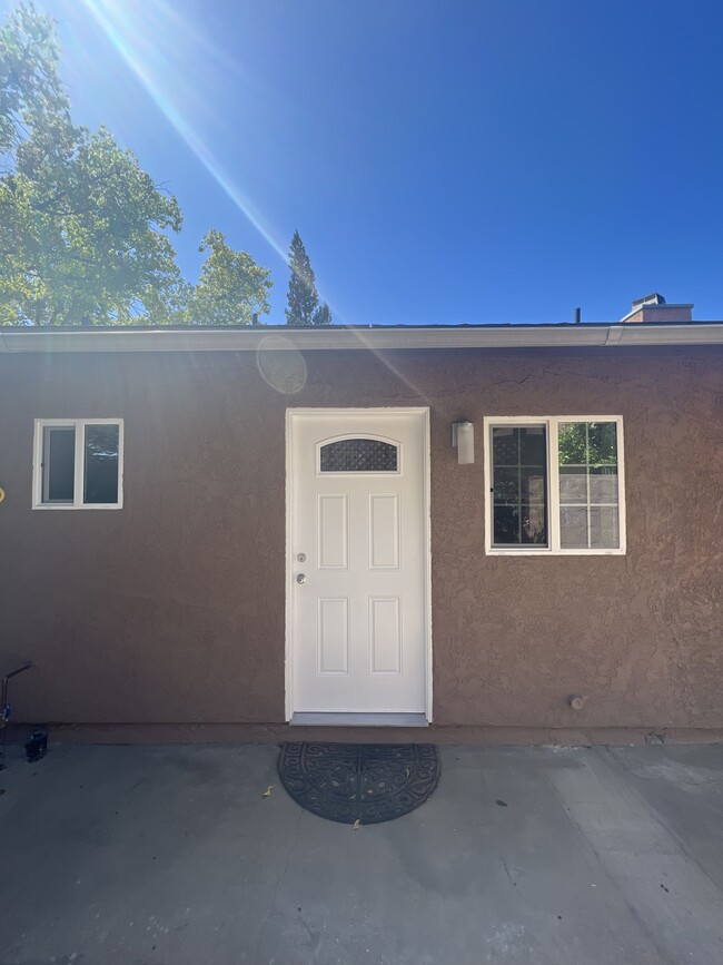
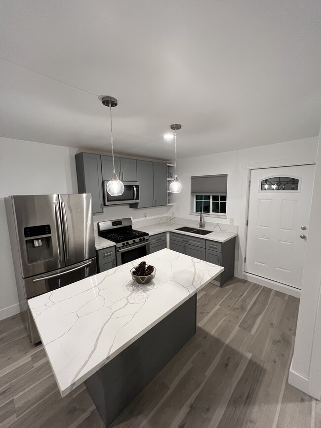
413 N Macneil St Unit 1 bedroom
San Fernando, CA 91340
1 Week Ago
|
Edit
Favorites
747-294-2466
-
Bedrooms
1
-
Bathrooms
1
-
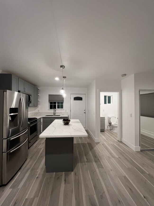
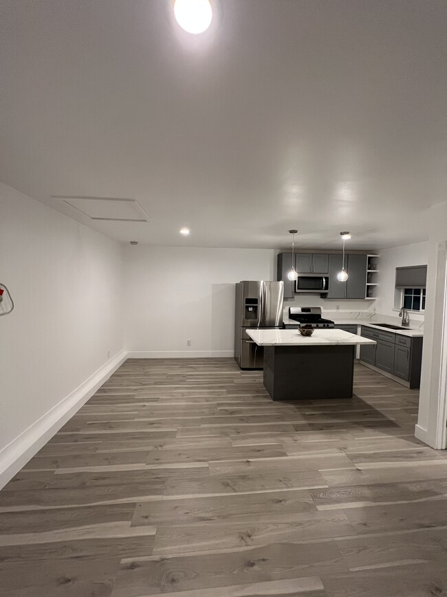
Square Feet
700 sq ft
-
Available
Available Now
413 N Macneil St

Favorites
About This Home
12 Month Lease,
$2,000 deposit,
Available Now
Alquiler de estudio: $1950 (incluye servicios públicos: internet, gas, basura, luz, cable). Depósito: $2000. Envíe un mensaje de texto para programar una cita.
413 N Macneil St is a house located in Los Angeles County and the 91340 ZIP Code. This area is served by the Los Angeles Unified Rocp School District attendance zone.
* Price shown is total price based on community-supplied monthly required fees. Excludes user-selected optional fees and variable or usage-based fees and required charges due at or prior to move-in or at move-out. Price, availability, fees, and any applicable rent special are subject to change without notice.
* Square footage definitions vary. Displayed square footage is approximate.
House Features
- Aire acondicionado
Fees and Policies
The fees listed below are community-provided and may exclude utilities or add-ons. All payments are made directly to the property and are non-refundable unless otherwise specified.
- One-Time Move-In Fees
-
Broker Fee$0
- Parking
-
Street--
Details
Utilities Included
-
Gas
-
Electricity
-
Heat
-
Trash Removal
Property Information
-
3 units
Contact
- Phone Number
Location
Get Directions
Nestled at the foothills of the San Gabriel Mountains, San Fernando is a small city in the northwestern region of Los Angeles County. Situated between Interstates 5 and 210, getting around from San Fernando is a breeze.
In addition to stunning mountain views, San Fernando boasts endless opportunities for outdoor recreation with close proximity to a number of parks such as Hansen Dam Recreation Center, Veterans Memorial Community Regional Park, Wilson Canyon Park, and O’Melveny Park. San Fernando is home to a diverse range of shopping and dining options, including the San Fernando Swap Meet and authentic Latin American cuisine. Discovery Cube Los Angeles and Nethercutt Museum are also close to San Fernando.
Learn more about living in San Fernando
Education
| Colleges & Universities | Distance | ||
|---|---|---|---|
| Colleges & Universities | Distance | ||
| Drive: | 5 min | 3.0 mi | |
| Drive: | 14 min | 7.8 mi | |
| Drive: | 15 min | 9.9 mi | |
| Drive: | 15 min | 10.0 mi |
413 N Macneil St is within 5 minutes or 3.0 miles from Mission College. It is also near Cal State Northridge and Woodbury University.
Schools


Public Elementary School
Grades K-5
Attendance Zone
Public Elementary, Middle & High School
Grades K-12
Nearby
Public Middle School
Grades 6-8
Attendance Zone
Private Elementary & Middle School
Grades K-8
245 Students
Nearby
Private Elementary, Middle & High School
Grades K-12
Nearby
Private Elementary School
Grades PK-5
Nearby
School data provided by
 The GreatSchools Rating helps parents compare schools within a state based on a variety of school quality indicators and provides a helpful picture of how effectively each school serves all of its students. Ratings are on a scale of 1 (below average) to 10 (above average) and can include test scores, college readiness, academic progress, advanced courses, equity, discipline and attendance data. We also advise parents to visit schools, consider other information on school performance and programs, and consider family needs as part of the school selection process.
View GreatSchools Rating Methodology
Data provided by GreatSchools.org © 2026. All rights reserved.
View GreatSchools Rating Methodology
Data provided by GreatSchools.org © 2026. All rights reserved.
Transportation options available in San Fernando include North Hollywood Station, located 10.4 miles from 413 N Macneil St. 413 N Macneil St is near Bob Hope, located 8.0 miles or 13 minutes away, and Los Angeles International, located 28.3 miles or 38 minutes away.
| Transit / Subway | Distance | ||
|---|---|---|---|
| Transit / Subway | Distance | ||
|
|
Drive: | 14 min | 10.4 mi |
| Commuter Rail | Distance | ||
|---|---|---|---|
| Commuter Rail | Distance | ||
|
|
Drive: | 3 min | 1.3 mi |
|
|
Drive: | 10 min | 6.1 mi |
|
|
Drive: | 11 min | 6.2 mi |
|
|
Drive: | 18 min | 10.1 mi |
|
|
Drive: | 18 min | 10.1 mi |
| Airports | Distance | ||
|---|---|---|---|
| Airports | Distance | ||
|
Bob Hope
|
Drive: | 13 min | 8.0 mi |
|
Los Angeles International
|
Drive: | 38 min | 28.3 mi |
Getting Around
 What do Walkability, Transit, Drivability, and Bikeability mean?
Walkability measures the walking distance to day-to-day needs.
Transit measures access to public transportation.
Drivability measures congestion, parking availability, and access to major roads.
Bikeability measures the suitability for cycling.
How It Works
What do Walkability, Transit, Drivability, and Bikeability mean?
Walkability measures the walking distance to day-to-day needs.
Transit measures access to public transportation.
Drivability measures congestion, parking availability, and access to major roads.
Bikeability measures the suitability for cycling.
How It Works
Moderately Walkable
Walkability
60
/ 100
Some Public Transit
Transit
40
/ 100
Very Drivable
Drivability
80
/ 100
Fairly Bikeable
Bikeability
40
/ 100
Scores provided by
Active
Soundscore™
69
/ 100
Traffic
BusyAirport
ActiveBusinesses
ActiveScores provided by
HowLoud What is a Sound Score Rating? A Sound Score Rating aggregates noise caused by vehicle traffic, airplane traffic and local sources. How It WorksTime and distance from 413 N Macneil St.
| Shopping Centers | Distance | ||
|---|---|---|---|
| Shopping Centers | Distance | ||
| Walk: | 8 min | 0.5 mi | |
| Walk: | 13 min | 0.7 mi | |
| Walk: | 14 min | 0.8 mi |
413 N Macneil St has 3 shopping centers within 0.8 mile, which is about a 14-minute walk. The miles and minutes will be for the farthest away property.
| Parks and Recreation | Distance | ||
|---|---|---|---|
| Parks and Recreation | Distance | ||
|
El Cariso Regional Park
|
Drive: | 6 min | 3.2 mi |
|
Veterans Memorial Park
|
Drive: | 10 min | 4.3 mi |
|
Aliso Canyon Park
|
Drive: | 14 min | 7.6 mi |
|
Wildlife Waystation
|
Drive: | 15 min | 9.4 mi |
|
Placerita Canyon State Park
|
Drive: | 17 min | 12.5 mi |
413 N Macneil St has 5 parks within 12.5 miles, including El Cariso Regional Park, Veterans Memorial Park, and Aliso Canyon Park.
| Hospitals | Distance | ||
|---|---|---|---|
| Hospitals | Distance | ||
| Drive: | 3 min | 1.7 mi | |
| Drive: | 7 min | 4.2 mi | |
| Drive: | 7 min | 4.3 mi |
413 N Macneil St has 3 hospitals within 4.3 miles, the nearest is Providence Holy Cross Medical Center which is 1.7 miles away and a 3 minute drive.
| Military Bases | Distance | ||
|---|---|---|---|
| Military Bases | Distance | ||
| Drive: | 38 min | 30.9 mi |
413 N Macneil St is 30.9 miles and a 38 minute drive from Los Angeles Air Force Base.
Amenities
- Aire acondicionado
413 N Macneil St Photos
What Are Walk Score®, Transit Score®, and Bike Score® Ratings?
Walk Score® measures the walkability of any address. Transit Score® measures access to public transit. Bike Score® measures the bikeability of any address.
What is a Sound Score Rating?
A Sound Score Rating aggregates noise caused by vehicle traffic, airplane traffic and local sources.

413 N Macneil St
San Fernando, CA 91340