
$2,095 / Month
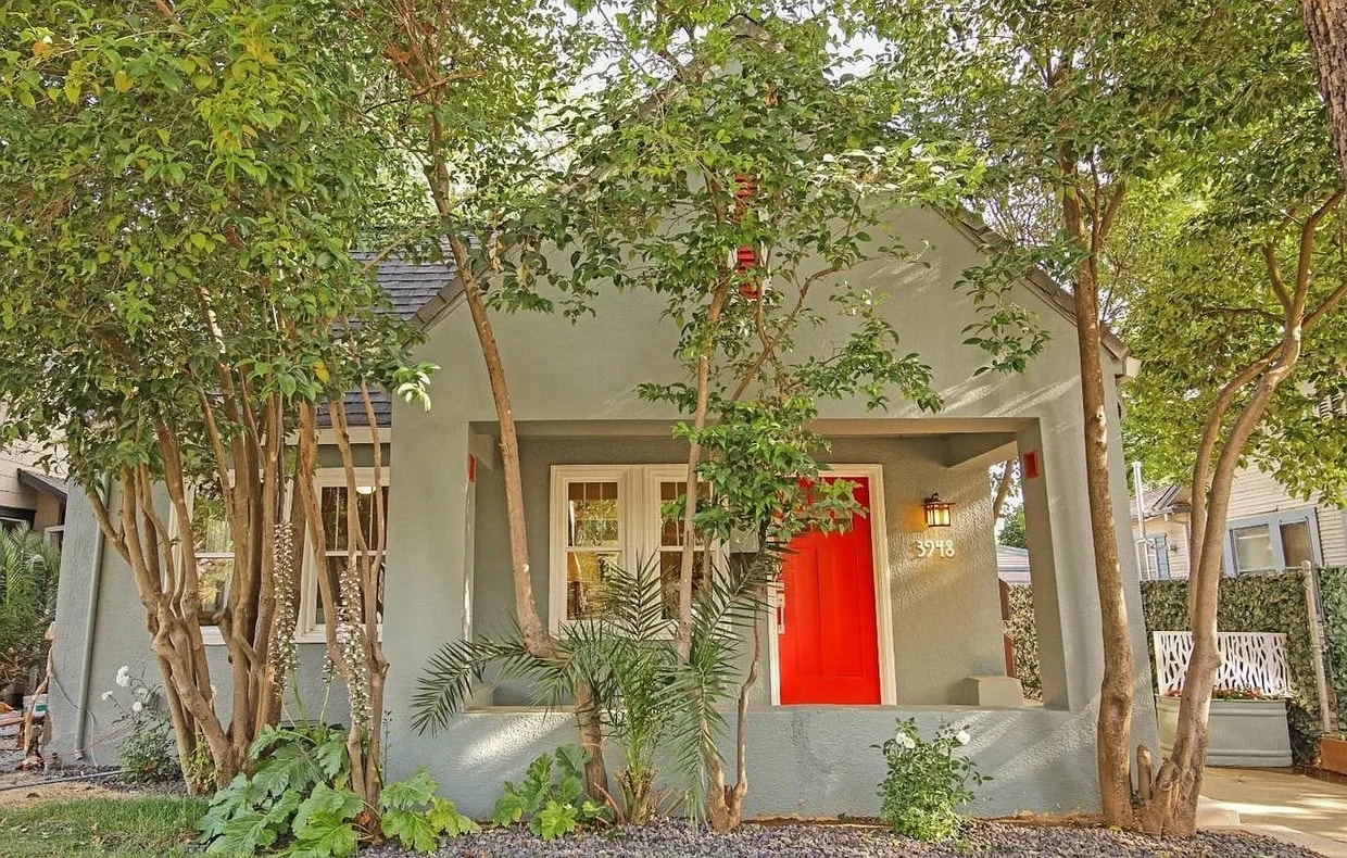
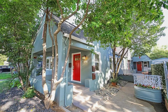
3948 Sherman Way
Sacramento, CA 95817
Today
Favorites
217-898-6642
-
Bedrooms
2
-
Bathrooms
1
-
Square Feet
1,000 sq ft
-
Available
Available Aug 1
3948 Sherman Way

Favorites
About This Home
$2,095 deposit,
Available Aug 1
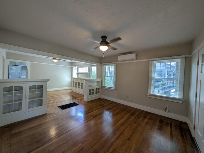
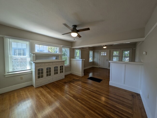
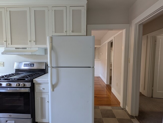
Located within 5 minutes walking distance from UC Davis Med Center and minutes of drive to Midtown, the property is a confluence of new and old! The property features: - hardwood floors - In unit washer and dryer - dishwasher - a newly renovated bathroom - a newly renovated kitchen The property retains many of the original cabinet and shelves from the early 20th century too! Amenities included: central air, central heat, deck, dishwasher, hardwood floors, updated kitchen, updated bathroom, and washer dryer. No Utilities included. Is pet friendly. Date Available: Aug 1st 2025. $2,000/month rent, $125 per month for water, sewage & garbage. $2,000 security deposit required. Please submit the form on this page to learn more.
3948 Sherman Way is a house located in Sacramento County and the 95817 ZIP Code. This area is served by the Sacramento City Unified attendance zone.
* Price shown is base rent and may not include non-optional fees and utilities.
Price, availability, fees, and any applicable rent special are subject to change without notice.
* Square footage definitions vary. Displayed square footage is approximate.
House Features
- Washer/Dryer
- Washer/Dryer Hookup
- Dishwasher
Fees and Policies
The fees below are based on community-supplied data and may exclude additional fees and utilities.
- Dogs Allowed
-
Fees not specified
- Cats Allowed
-
Fees not specified
Contact
- Listed by Jason
- Phone Number
- Contact
Location
Get Directions
Amenities
- Washer/Dryer
- Washer/Dryer Hookup
- Dishwasher
As its name implies, Med Center is home to several medical facilities. A Shriners Hospitals for Children, the University of California Davis Medical Center, the University of California Davis School of Medicine, and other medical facilities are in this neighborhood. Along with housing the Sacramento Charter High School, Med Center is convenient to several excellent schools including the Pacific McGeorge School of Law. A popular choice amongst families, graduate students, and medical professionals, Med Center features upscale rental options within or near the neighborhood. There are only a few small cafes in the community, but Midtown and Downtown Sacramento are less than five miles away, giving residents access to a wide variety of shopping, dining, and entertainment options.
Learn more about living in Med Center
Education
| Colleges & Universities | Distance | ||
|---|---|---|---|
| Colleges & Universities | Distance | ||
| Drive: | 7 min | 2.6 mi | |
| Drive: | 9 min | 4.3 mi | |
| Drive: | 17 min | 9.7 mi | |
| Drive: | 18 min | 11.2 mi |
3948 Sherman Way is within 7 minutes or 2.6 miles from Sacramento City College. It is also near Sacramento State and Cosumnes River College.
Schools


Public Elementary School
Grades K-6
449 Students
Attendance Zone
Public Elementary School
Grades K-3
372 Students
Nearby
Public Middle & High School
Grades 7-12
536 Students
Attendance Zone
Public High School
Grades 9-12
1,733 Students
Attendance Zone
Private Elementary & Middle School
Grades K-8
Nearby
Private Elementary & Middle School
Grades PK-8
Nearby
Private Middle & High School
Grades 7-12
Nearby
School data provided by
 The GreatSchools Rating helps parents compare schools within a state based on a variety of school quality indicators and provides a helpful picture of how effectively each school serves all of its students. Ratings are on a scale of 1 (below average) to 10 (above average) and can include test scores, college readiness, academic progress, advanced courses, equity, discipline and attendance data. We also advise parents to visit schools, consider other information on school performance and programs, and consider family needs as part of the school selection process.
View GreatSchools Rating Methodology
Data provided by GreatSchools.org © 2025. All rights reserved.
View GreatSchools Rating Methodology
Data provided by GreatSchools.org © 2025. All rights reserved.
Transportation options available in Sacramento include 39Th Street, located 0.6 mile from 3948 Sherman Way. 3948 Sherman Way is near Sacramento International, located 15.2 miles or 22 minutes away.
| Transit / Subway | Distance | ||
|---|---|---|---|
| Transit / Subway | Distance | ||
|
|
Walk: | 12 min | 0.6 mi |
|
|
Drive: | 5 min | 1.7 mi |
|
|
Drive: | 4 min | 1.7 mi |
|
|
Drive: | 4 min | 1.9 mi |
|
|
Drive: | 5 min | 2.4 mi |
| Commuter Rail | Distance | ||
|---|---|---|---|
| Commuter Rail | Distance | ||
| Drive: | 8 min | 3.7 mi | |
|
|
Drive: | 21 min | 16.8 mi |
|
|
Drive: | 27 min | 19.9 mi |
|
|
Drive: | 28 min | 22.0 mi |
|
|
Drive: | 43 min | 33.8 mi |
| Airports | Distance | ||
|---|---|---|---|
| Airports | Distance | ||
|
Sacramento International
|
Drive: | 22 min | 15.2 mi |
Time and distance from 3948 Sherman Way.
| Shopping Centers | Distance | ||
|---|---|---|---|
| Shopping Centers | Distance | ||
| Walk: | 12 min | 0.6 mi | |
| Walk: | 14 min | 0.8 mi | |
| Walk: | 15 min | 0.8 mi |
3948 Sherman Way has 3 shopping centers within 0.8 mile, which is about a 15-minute walk. The miles and minutes will be for the farthest away property.
| Parks and Recreation | Distance | ||
|---|---|---|---|
| Parks and Recreation | Distance | ||
|
Sutter's Fort State Historical Monument
|
Drive: | 4 min | 1.7 mi |
|
California State Capitol Museum
|
Drive: | 6 min | 2.6 mi |
|
Leland Stanford Mansion State Historic Park
|
Drive: | 6 min | 2.7 mi |
|
Paradise Beach County Recreation Area
|
Drive: | 8 min | 3.0 mi |
|
California Native Plant Demonstration Garden
|
Drive: | 7 min | 3.3 mi |
3948 Sherman Way has 5 parks within 3.3 miles, including Sutter's Fort State Historical Monument, California Native Plant Demonstration Garden, and Leland Stanford Mansion State Historic Park.
| Hospitals | Distance | ||
|---|---|---|---|
| Hospitals | Distance | ||
| Walk: | 3 min | 0.2 mi | |
| Walk: | 5 min | 0.3 mi | |
| Drive: | 5 min | 1.3 mi |
3948 Sherman Way has 3 hospitals within 1.3 miles, the nearest is University of California Davis Medical Center which is 0.2 mile away and a 3 minute walk.
| Military Bases | Distance | ||
|---|---|---|---|
| Military Bases | Distance | ||
| Drive: | 25 min | 12.2 mi |
3948 Sherman Way is 12.2 miles and a 25 minute drive from McClellan Air Force Base.
You May Also Like
Similar Rentals Nearby


What Are Walk Score®, Transit Score®, and Bike Score® Ratings?
Walk Score® measures the walkability of any address. Transit Score® measures access to public transit. Bike Score® measures the bikeability of any address.
What is a Sound Score Rating?
A Sound Score Rating aggregates noise caused by vehicle traffic, airplane traffic and local sources

3948 Sherman Way
Sacramento, CA 95817