
$2,400
/ Month
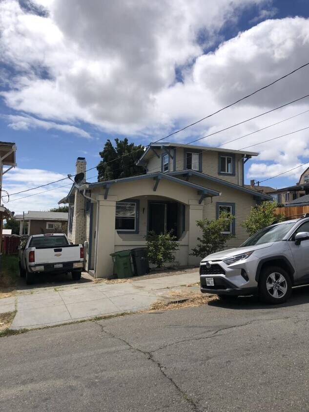
3923 Santa Rita St
Oakland, CA 94601
Today
|
Edit
Favorites
-
Bedrooms
2
-
Bathrooms
1
-
Square Feet
940 sq ft
-
Available
Available Dec 3
3923 Santa Rita St

Favorites
About This Home
Available Dec 3
Welcome to your new home in vibrant Oakland! This charming residence offers 940 sq ft of comfortable living space. The well-appointed kitchen is perfect for culinary enthusiasts, featuring ample cabinetry for storage. The living area is enhanced by a classic fireplace, ideal for cozy evenings. The home boasts two bedrooms and one full bathroom, providing a functional layout for everyday living. With essential heating provided by a wall furnace and cooling options absent, the home combines simplicity with practicality. This Oakland gem is ready to welcome you with its inviting atmosphere and straightforward charm. Don't miss the chance to explore this delightful property!
3923 Santa Rita St is a house located in Alameda County and the 94601 ZIP Code.
* Price shown is base rent. Excludes user-selected optional fees and variable or usage-based fees and required charges due at or prior to move-in or at move-out. Price, availability, fees, and any applicable rent special are subject to change without notice.
* Square footage definitions vary. Displayed square footage is approximate.
Contact
- Listed by Gerardo Cortes | Intero Real Estate Services
- Contact
-
Source
 MLSListings Inc.
Copyright © 2025 MLSListings Inc.
Location
Get Directions
Just five miles from Downtown Oakland, Jefferson is a residential community with a variety of schools, parks, salons, and churches. Brookdale Park and Courtland Creek Park are both located in Jefferson. Brookdale Park houses the recreation center which offers several programs for the youth in the community. Courtland Creek Park showcases local art outdoors. Global Family Elementary School teaches students to be bilingual from the start of kindergarten.
Commuting and traveling from Jefferson is easy with convenient access to I-580 and I-880 as well as the Fruitvale BART station. Oakland International Airport is only six miles from Jefferson too.
Learn more about living in Jefferson
Education
| Colleges & Universities | Distance | ||
|---|---|---|---|
| Colleges & Universities | Distance | ||
| Drive: | 7 min | 2.1 mi | |
| Drive: | 7 min | 3.5 mi | |
| Drive: | 9 min | 4.3 mi | |
| Drive: | 12 min | 6.6 mi |
3923 Santa Rita St is within 7 minutes or 2.1 miles from Mills College. It is also near Laney College and Lincoln University, Oakland.
Transportation options available in Oakland include Fruitvale Station, located 1.2 miles from 3923 Santa Rita St. 3923 Santa Rita St is near Metro Oakland International, located 6.4 miles or 11 minutes away, and San Francisco International, located 27.1 miles or 40 minutes away.
| Transit / Subway | Distance | ||
|---|---|---|---|
| Transit / Subway | Distance | ||
|
|
Drive: | 3 min | 1.2 mi |
|
|
Drive: | 5 min | 2.8 mi |
|
|
Drive: | 8 min | 4.3 mi |
|
|
Drive: | 9 min | 4.6 mi |
|
|
Drive: | 8 min | 4.7 mi |
| Commuter Rail | Distance | ||
|---|---|---|---|
| Commuter Rail | Distance | ||
|
|
Drive: | 8 min | 4.8 mi |
|
|
Drive: | 12 min | 8.1 mi |
|
|
Drive: | 15 min | 10.2 mi |
|
|
Drive: | 17 min | 11.7 mi |
| Drive: | 17 min | 11.7 mi |
| Airports | Distance | ||
|---|---|---|---|
| Airports | Distance | ||
|
Metro Oakland International
|
Drive: | 11 min | 6.4 mi |
|
San Francisco International
|
Drive: | 40 min | 27.1 mi |
Time and distance from 3923 Santa Rita St.
| Shopping Centers | Distance | ||
|---|---|---|---|
| Shopping Centers | Distance | ||
| Walk: | 13 min | 0.7 mi | |
| Walk: | 16 min | 0.9 mi | |
| Walk: | 17 min | 0.9 mi |
3923 Santa Rita St has 3 shopping centers within 0.9 mile, which is about a 17-minute walk. The miles and minutes will be for the farthest away property.
| Parks and Recreation | Distance | ||
|---|---|---|---|
| Parks and Recreation | Distance | ||
|
Lakeside Park
|
Drive: | 7 min | 4.5 mi |
|
Roberts Regional Recreation Area
|
Drive: | 11 min | 4.9 mi |
|
Martin Luther King Jr. Regional Shoreline
|
Drive: | 11 min | 5.4 mi |
|
Chabot Space & Science Center
|
Drive: | 14 min | 5.6 mi |
|
Joaquin Miller Park
|
Drive: | 13 min | 5.7 mi |
3923 Santa Rita St has 5 parks within 5.7 miles, including Lakeside Park, Joaquin Miller Park, and Martin Luther King Jr. Regional Shoreline.
| Hospitals | Distance | ||
|---|---|---|---|
| Hospitals | Distance | ||
| Drive: | 3 min | 1.6 mi | |
| Drive: | 6 min | 2.9 mi | |
| Drive: | 9 min | 3.5 mi |
3923 Santa Rita St has 3 hospitals within 3.5 miles, the nearest is Telecare Heritage Psychiatric Health Facility which is 1.6 miles away and a 3 minute drive.
| Military Bases | Distance | ||
|---|---|---|---|
| Military Bases | Distance | ||
| Drive: | 16 min | 8.2 mi | |
| Drive: | 17 min | 8.3 mi |
3923 Santa Rita St is 8.2 miles from Alameda/US Naval Air Station Alameda, and is convenient to other military bases, including Oakland Army Base.
You May Also Like
Similar Rentals Nearby


What Are Walk Score®, Transit Score®, and Bike Score® Ratings?
Walk Score® measures the walkability of any address. Transit Score® measures access to public transit. Bike Score® measures the bikeability of any address.
What is a Sound Score Rating?
A Sound Score Rating aggregates noise caused by vehicle traffic, airplane traffic and local sources

3923 Santa Rita St
Oakland, CA 94601