
$2,050
/ Month
39 thomas St Unit 2ND
Staten Island, NY 10306
2 Weeks Ago
|
Edit
Favorites
39 thomas St Unit 2ND

Favorites
Check Back Soon for Upcoming Availability
| Beds | Baths | Average SF |
|---|---|---|
| 3 Bedrooms 3 Bedrooms 3 Br | 1 Bath 1 Bath 1 Ba | 1,100 SF |
About This Property
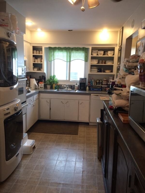
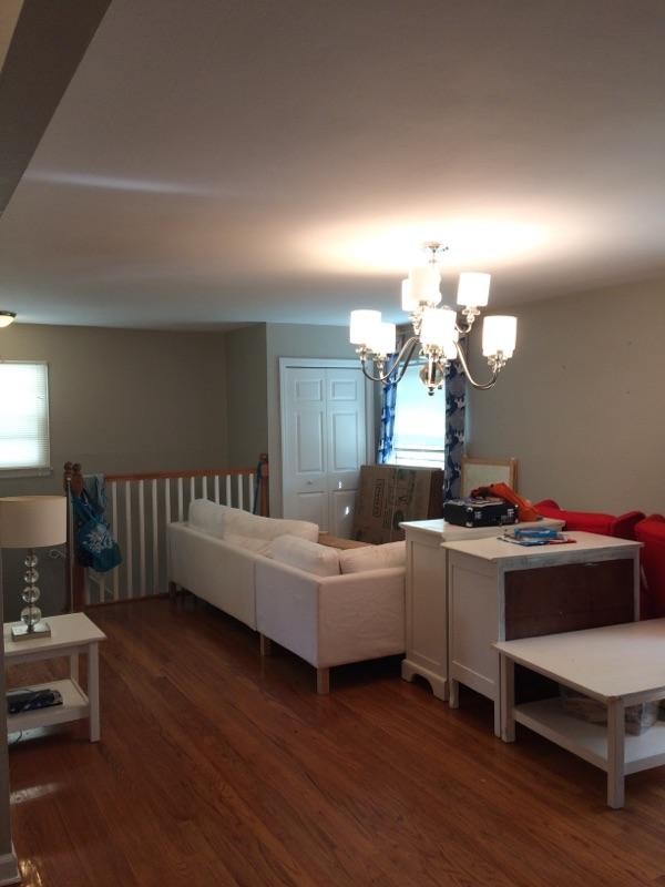
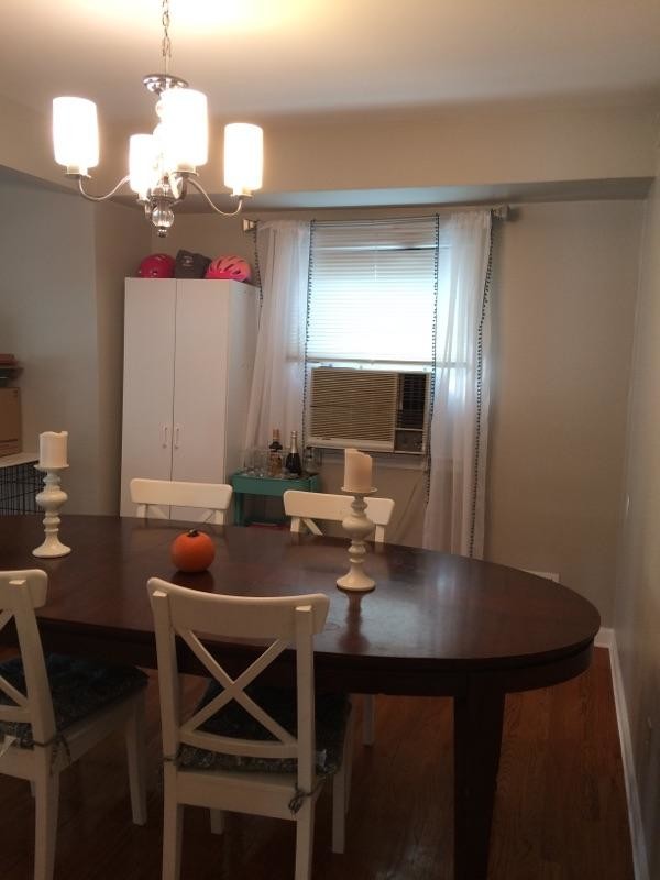
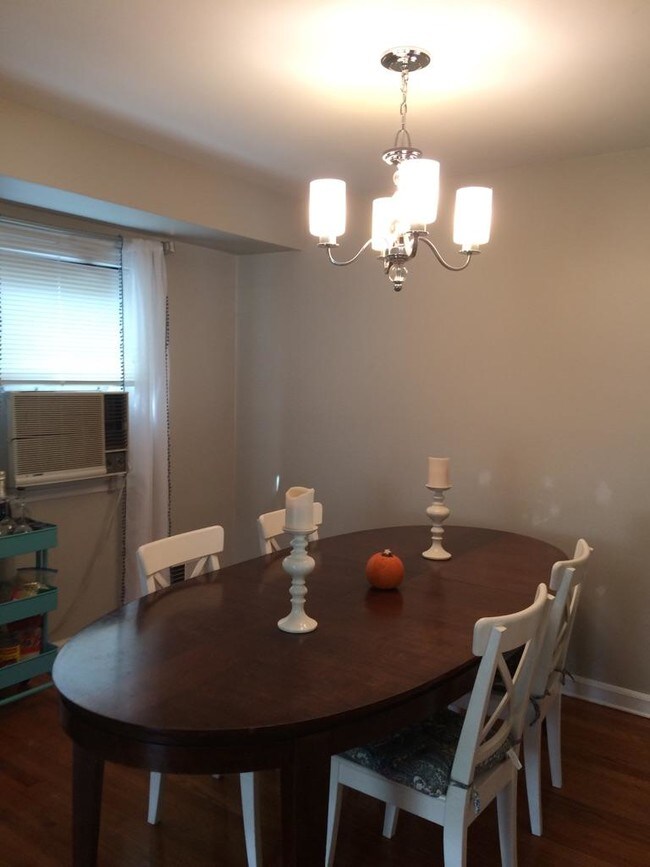
JUST LISTED!Six Room Apartment. Large 3 Bedroom with living and dining room. Eat in kitchen. Right on Oakwood, Staten Island!Move in Ready!Washer DryerDishwasher2nd Floor, private homeHardwood FloorsTenant pays own UTLS.Call Today!
39 Thomas St is a condo located in Richmond County and the 10306 ZIP Code. This area is served by the New York City Geographic District #31 attendance zone.
Condo Features
- Washer/Dryer
- Hardwood Floors
39 thomas St,
Staten Island,
NY
10306
Staten Island occupies a singular position as New York City's southernmost borough, physically separate from the rest of the city yet firmly connected to it through the iconic, round-the-clock Staten Island Ferry. As the least densely populated of the five boroughs, it carries a noticeably quieter, more residential character than Manhattan or Brooklyn, covering roughly 59 square miles with a population near 490,000. The College of Staten Island anchors the borough's educational presence, while Snug Harbor Cultural Center and Botanical Garden reflects a deep commitment to the arts and green space. During the American Revolution, Staten Island served as a primary staging ground for British forces and remained under British control longer than any other part of what would become the United States.
Neighborhoods vary considerably across the island. St. George on the North Shore functions as the civic and cultural hub, while Tottenville anchors the quieter South Shore.
Learn more about living in Staten IslandBelow are rent ranges for similar nearby apartments
Amenities
- Washer/Dryer
- Hardwood Floors
Education
| Colleges & Universities | Distance | ||
|---|---|---|---|
| Colleges & Universities | Distance | ||
| Drive: | 12 min | 3.8 mi | |
| Drive: | 16 min | 5.6 mi | |
| Drive: | 22 min | 10.1 mi | |
| Drive: | 25 min | 11.8 mi |
39 thomas St Unit 2ND is within 12 minutes or 3.8 miles from Coll. of Staten Island, CUNY. It is also near Wagner College and Union County Coll., Elizabeth.
Schools


Public Elementary School
Grades PK-5
609 Students
Attendance Zone
Public Middle School
Grades 6-8
1,314 Students
Attendance Zone
Public High School
Grades 9-12
3,050 Students
Attendance Zone
Private Elementary & Middle School
Grades PK-8
688 Students
Nearby
Private Elementary & Middle School
Grades K-8
138 Students
Nearby
Private High School
Grades 9-12
783 Students
Nearby
School data provided by
 The GreatSchools Rating helps parents compare schools within a state based on a variety of school quality indicators and provides a helpful picture of how effectively each school serves all of its students. Ratings are on a scale of 1 (below average) to 10 (above average) and can include test scores, college readiness, academic progress, advanced courses, equity, discipline and attendance data. We also advise parents to visit schools, consider other information on school performance and programs, and consider family needs as part of the school selection process.
View GreatSchools Rating Methodology
Data provided by GreatSchools.org © 2026. All rights reserved.
View GreatSchools Rating Methodology
Data provided by GreatSchools.org © 2026. All rights reserved.
Transportation options available in Staten Island include Bay Ridge-95 Street, located 8.1 miles from 39 thomas St Unit 2ND. 39 thomas St Unit 2ND is near Newark Liberty International, located 16.4 miles or 29 minutes away, and John F Kennedy International, located 27.2 miles or 43 minutes away.
| Transit / Subway | Distance | ||
|---|---|---|---|
| Transit / Subway | Distance | ||
|
|
Drive: | 17 min | 8.1 mi |
| Drive: | 17 min | 8.1 mi | |
|
|
Drive: | 17 min | 8.4 mi |
|
|
Drive: | 18 min | 8.9 mi |
|
|
Drive: | 19 min | 9.3 mi |
| Commuter Rail | Distance | ||
|---|---|---|---|
| Commuter Rail | Distance | ||
|
|
Walk: | 7 min | 0.4 mi |
|
|
Walk: | 18 min | 0.9 mi |
|
|
Walk: | 18 min | 1.0 mi |
|
|
Drive: | 4 min | 1.5 mi |
|
|
Drive: | 6 min | 1.8 mi |
| Airports | Distance | ||
|---|---|---|---|
| Airports | Distance | ||
|
Newark Liberty International
|
Drive: | 29 min | 16.4 mi |
|
John F Kennedy International
|
Drive: | 43 min | 27.2 mi |
Walkability Near 39 thomas St Staten Island, NY 10306
Getting Around
 What do Walkability, Transit, Drivability, and Bikeability mean?
Walkability measures the walking distance to day-to-day needs.
Transit measures access to public transportation.
Drivability measures congestion, parking availability, and access to major roads.
Bikeability measures the suitability for cycling.
How It Works
What do Walkability, Transit, Drivability, and Bikeability mean?
Walkability measures the walking distance to day-to-day needs.
Transit measures access to public transportation.
Drivability measures congestion, parking availability, and access to major roads.
Bikeability measures the suitability for cycling.
How It Works
Moderately Walkable
Walkability
70
/ 100
Good Public Transit
Transit
70
/ 100
Fairly Drivable
Drivability
50
/ 100
Moderately Bikeable
Bikeability
70
/ 100
Scores provided by
-
Soundscore™
-
/ 100
Traffic
-Airport
-Businesses
-Scores provided by
HowLoud What is a Sound Score Rating? A Sound Score Rating aggregates noise caused by vehicle traffic, airplane traffic and local sources. How It WorksTime and distance from 39 thomas St Unit 2ND.
| Shopping Centers | Distance | ||
|---|---|---|---|
| Shopping Centers | Distance | ||
| Walk: | 6 min | 0.4 mi | |
| Walk: | 12 min | 0.6 mi | |
| Drive: | 4 min | 1.3 mi |
39 thomas St Unit 2ND has 3 shopping centers within 1.3 miles, which is about a 4-minute drive. The miles and minutes will be for the farthest away property.
| Parks and Recreation | Distance | ||
|---|---|---|---|
| Parks and Recreation | Distance | ||
|
Gateway NRA - Staten Island Unit - Great Kills Park
|
Drive: | 4 min | 1.1 mi |
|
Blood Root Valley
|
Drive: | 4 min | 1.7 mi |
|
High Rock Park
|
Drive: | 5 min | 1.7 mi |
|
Greenbelt Nature Center
|
Drive: | 5 min | 2.0 mi |
|
Greenbelt
|
Drive: | 7 min | 2.7 mi |
39 thomas St Unit 2ND has 5 parks within 2.7 miles, including Gateway NRA - Staten Island Unit - Great Kills Park, Blood Root Valley, and High Rock Park.
| Hospitals | Distance | ||
|---|---|---|---|
| Hospitals | Distance | ||
| Drive: | 8 min | 3.3 mi | |
| Drive: | 10 min | 3.8 mi | |
| Drive: | 16 min | 6.2 mi |
39 thomas St Unit 2ND has 3 hospitals within 6.2 miles, the nearest is Staten Island University Hospital which is 3.3 miles away and a 8 minute drive.
| Military Bases | Distance | ||
|---|---|---|---|
| Military Bases | Distance | ||
| Drive: | 17 min | 6.9 mi | |
| Drive: | 18 min | 8.5 mi |
39 thomas St Unit 2ND is 6.9 miles from Naval Station NY Stapleton Site, and is convenient to other military bases, including Fort Hamilton.
You May Also Like
Similar Rentals Nearby


What Are Walk Score®, Transit Score®, and Bike Score® Ratings?
Walk Score® measures the walkability of any address. Transit Score® measures access to public transit. Bike Score® measures the bikeability of any address.
What is a Sound Score Rating?
A Sound Score Rating aggregates noise caused by vehicle traffic, airplane traffic and local sources.

39 thomas St
Staten Island, NY 10306