

$3,500
/ Month
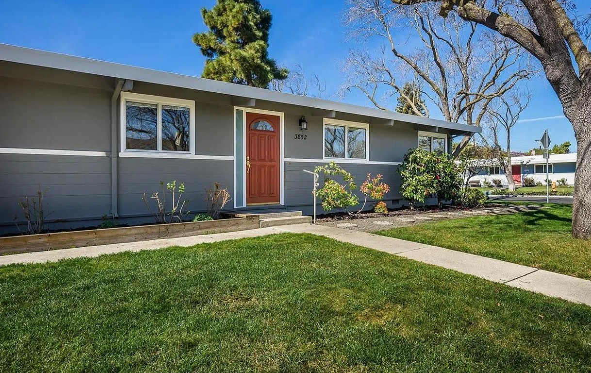
3852 Corina Way
Palo Alto, CA 94303
Today
Favorites
234-434-2561
-
Bedrooms
3
-
Bathrooms
2
-
Square Feet
1,250 sq ft
-
Available
Available Now
3852 Corina Way

Favorites
About This Home
$3,500 deposit,
Available Now
Beautiful 3 bed, 2 bath clean house in amazing Adobe Meadows neighborhood. Awesome yard and street, close to parks, shopping, library, all the commute routes. Can't get a location better than this. Beautiful 3 bed, 2 bath clean house in amazing Adobe Meadows neighborhood. Awesome yard and street, close to parks, shopping, library, all the commute routes. Can't get a location better than this.
3852 Corina Way is a house located in Santa Clara County and the 94303 ZIP Code. This area is served by the Palo Alto Unified attendance zone.
* Price shown is base rent and may not include non-optional fees and utilities. Price, availability, fees, and any applicable rent special are subject to change without notice.
* Square footage definitions vary. Displayed square footage is approximate.
House Features
Washer/Dryer
Air Conditioning
Dishwasher
Hardwood Floors
- Washer/Dryer
- Air Conditioning
- Cable Ready
- Fireplace
- Wheelchair Accessible (Rooms)
- Dishwasher
- Disposal
- Microwave
- Range
- Refrigerator
- Hardwood Floors
- Storage Space
Fees and Policies
The fees below are based on community-supplied data and may exclude additional fees and utilities.
- Parking
-
Garage--
Contact
- Phone Number
- Contact
Location
Get Directions
Amenities
- Washer/Dryer
- Air Conditioning
- Cable Ready
- Fireplace
- Wheelchair Accessible (Rooms)
- Dishwasher
- Disposal
- Microwave
- Range
- Refrigerator
- Hardwood Floors
- Storage Space
Palo Alto is known as the birthplace of Silicon Valley and that unique heritage is proudly on display, with the Computer History Museum just down the street from Google’s world headquarters and countless other tech companies all over town. The restaurant scene rivals that of nearby San Francisco, with many small, independent eateries serving up some of the best food in the Bay Area.
With close proximity to the country’s tech center, it’s no surprise that Palo Alto apartments come with some of the most incredible amenities around. Residents also have access to dozens of options for outdoor recreation, including the gorgeous hiking and biking trails through the surrounding nature preserves, several golf courses, and easy access to San Francisco Bay. Bicycling is a popular mode of transportation around Palo Alto, with many bike-friendly routes around the city.
Palo Alto is famous as the home of Stanford University, and the campus is one of the most dominant landmarks in the area.
Learn more about living in Palo Alto
Education
| Colleges & Universities | Distance | ||
|---|---|---|---|
| Colleges & Universities | Distance | ||
| Walk: | 15 min | 0.8 mi | |
| Drive: | 12 min | 4.3 mi | |
| Drive: | 14 min | 5.6 mi | |
| Drive: | 16 min | 6.4 mi |
3852 Corina Way is within 15 minutes or 0.8 mile from Foothill College, Middlefield. It is also near Stanford University and Foothill Coll., Los Altos.
Schools


Public Elementary School
Grades K-5
403 Students
Attendance Zone
Public Elementary School
Grades K-5
367 Students
Nearby
Public Middle School
Grades 6-8
996 Students
Attendance Zone
Public High School
Grades 9-12
1,787 Students
Attendance Zone
Private Elementary, Middle & High School
Grades K-12
Nearby
Private Elementary & Middle School
Grades PK-8
Nearby
Private High School
Grades 9-12
188 Students
Nearby
School data provided by
 The GreatSchools Rating helps parents compare schools within a state based on a variety of school quality indicators and provides a helpful picture of how effectively each school serves all of its students. Ratings are on a scale of 1 (below average) to 10 (above average) and can include test scores, college readiness, academic progress, advanced courses, equity, discipline and attendance data. We also advise parents to visit schools, consider other information on school performance and programs, and consider family needs as part of the school selection process.
View GreatSchools Rating Methodology
Data provided by GreatSchools.org © 2025. All rights reserved.
View GreatSchools Rating Methodology
Data provided by GreatSchools.org © 2025. All rights reserved.
Transportation options available in Palo Alto include Bayshore Nasa Station, located 3.9 miles from 3852 Corina Way. 3852 Corina Way is near Norman Y Mineta San Jose International, located 11.4 miles or 17 minutes away, and San Francisco International, located 23.2 miles or 31 minutes away.
| Transit / Subway | Distance | ||
|---|---|---|---|
| Transit / Subway | Distance | ||
| Drive: | 6 min | 3.9 mi | |
|
|
Drive: | 7 min | 4.0 mi |
| Drive: | 7 min | 4.3 mi | |
|
|
Drive: | 7 min | 4.3 mi |
|
|
Drive: | 8 min | 4.4 mi |
| Commuter Rail | Distance | ||
|---|---|---|---|
| Commuter Rail | Distance | ||
| Drive: | 5 min | 2.1 mi | |
| Drive: | 7 min | 2.8 mi | |
| Drive: | 8 min | 3.1 mi | |
| Drive: | 9 min | 3.8 mi | |
| Drive: | 10 min | 4.0 mi |
| Airports | Distance | ||
|---|---|---|---|
| Airports | Distance | ||
|
Norman Y Mineta San Jose International
|
Drive: | 17 min | 11.4 mi |
|
San Francisco International
|
Drive: | 31 min | 23.2 mi |
Time and distance from 3852 Corina Way.
| Shopping Centers | Distance | ||
|---|---|---|---|
| Shopping Centers | Distance | ||
| Walk: | 13 min | 0.7 mi | |
| Walk: | 17 min | 0.9 mi | |
| Walk: | 18 min | 1.0 mi |
3852 Corina Way has 3 shopping centers within 1.0 mile, which is about a 18-minute walk. The miles and minutes will be for the farthest away property.
| Parks and Recreation | Distance | ||
|---|---|---|---|
| Parks and Recreation | Distance | ||
|
J. Pearce Mitchell Park
|
Walk: | 11 min | 0.6 mi |
|
Terman Park
|
Drive: | 7 min | 2.3 mi |
|
Bol Park
|
Drive: | 8 min | 2.7 mi |
|
Stevens Creek Shoreline Nature Study Area
|
Drive: | 8 min | 3.0 mi |
|
The Environmental Volunteers EcoCenter
|
Drive: | 9 min | 3.9 mi |
3852 Corina Way has 5 parks within 3.9 miles, including J. Pearce Mitchell Park, Terman Park, and Bol Park.
| Hospitals | Distance | ||
|---|---|---|---|
| Hospitals | Distance | ||
| Drive: | 13 min | 4.9 mi | |
| Drive: | 9 min | 5.4 mi | |
| Drive: | 14 min | 5.4 mi |
3852 Corina Way has 3 hospitals within 5.4 miles, the nearest is Lucile Salter Packard Children's Hospital at Stanford which is 4.9 miles away and a 13 minute drive.
| Military Bases | Distance | ||
|---|---|---|---|
| Military Bases | Distance | ||
| Drive: | 10 min | 4.3 mi |
3852 Corina Way is 4.3 miles and a 10 minute drive from Ames Research Center.
You May Also Like
Similar Rentals Nearby


What Are Walk Score®, Transit Score®, and Bike Score® Ratings?
Walk Score® measures the walkability of any address. Transit Score® measures access to public transit. Bike Score® measures the bikeability of any address.
What is a Sound Score Rating?
A Sound Score Rating aggregates noise caused by vehicle traffic, airplane traffic and local sources
3852 Corina Way
Palo Alto, CA 94303