

$5,900 / Month
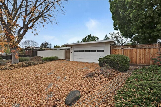
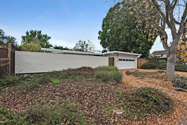
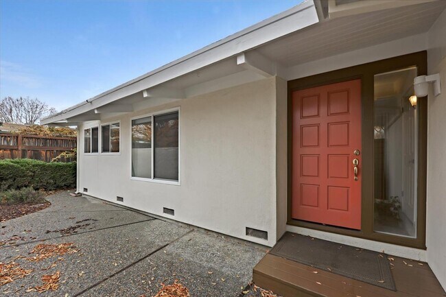
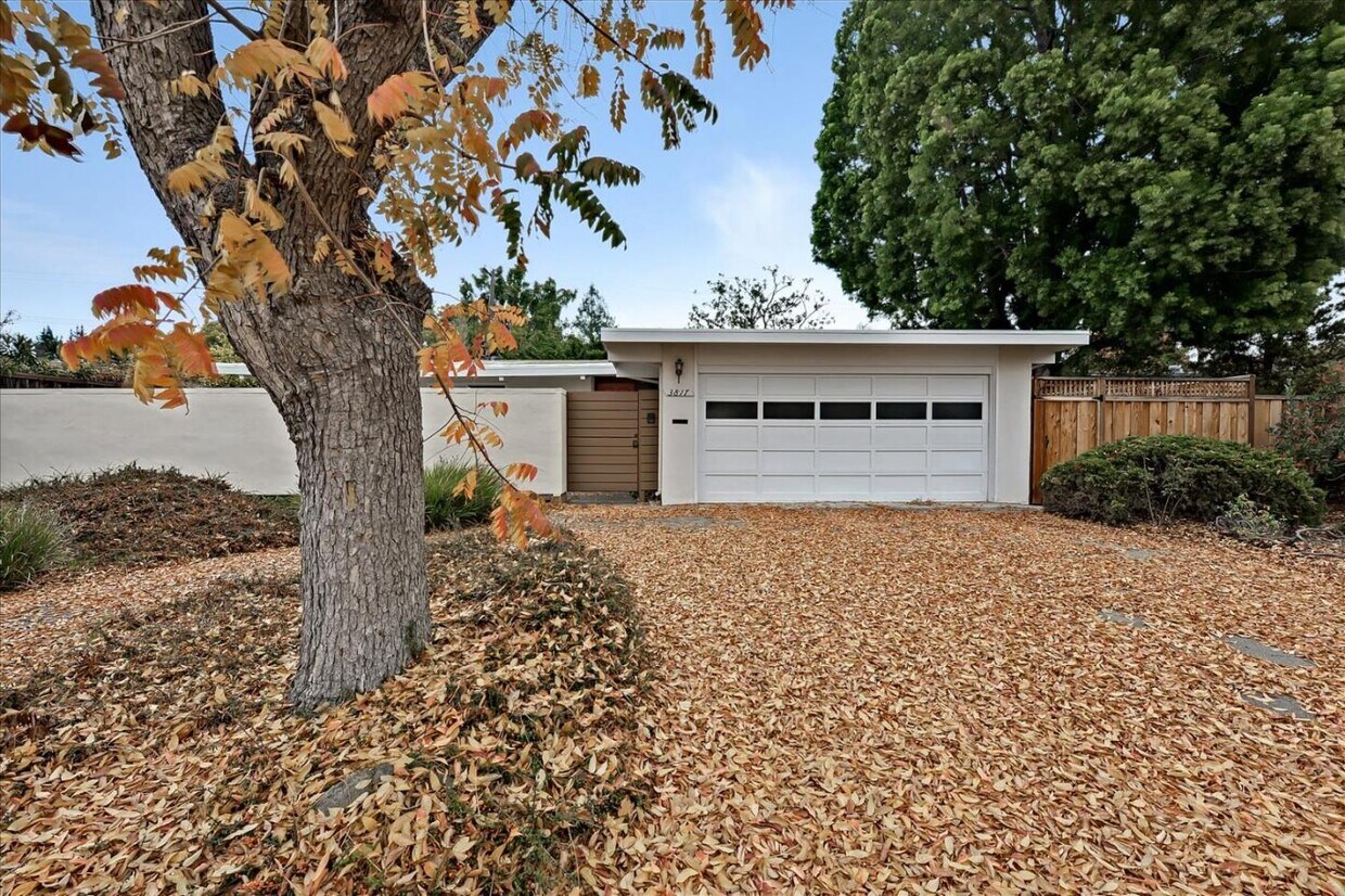
3817 Corina Way
Palo Alto, CA 94303
2 Weeks Ago
Favorites
3817 Corina Way

Favorites
Check Back Soon for Upcoming Availability
| Beds | Baths | Average SF |
|---|---|---|
| 3 Bedrooms 3 Bedrooms 3 Br | 2 Baths 2 Baths 2 Ba | 1,486 SF |
About This Property
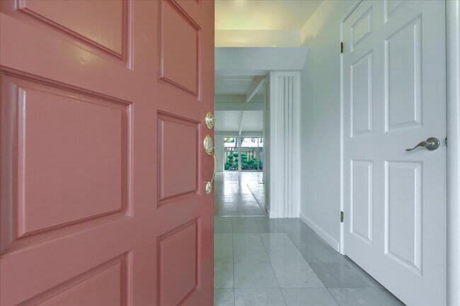
This bright and spacious home greets you with a tranquil courtyard - perfect for entertaining. Indulge in indoor relaxation in the open concept floor plan in hardwood flooring that opens up to a spacious backyard. Abundant natural light flows from skylights and clerestory windows, with vaulted ceilings and tasteful interiors setting the relaxing mood as you lounge indoors. The recently remodeled kitchen features quartz countertops that extend into a dining bar and stainless steel appliances. Good-sized bedrooms offer plenty of closet space and a great night's rest! The primary bedroom showcases a private entry to the yard and a sleek ensuite with a glass-enclosed shower. Your new home comes with an attached 2-car garage and an in-unit washer and dryer for your convenience. Located in a serene neighborhood and are just a few steps away from parks, recreation, and the library. Easy access to Midtown Shopping Center, Charleston Plaza, and major thoroughfares. Excellent schools nearby!
3817 Corina Way is a house located in Santa Clara County and the 94303 ZIP Code. This area is served by the Palo Alto Unified attendance zone.
Location
Get Directions
Palo Alto is known as the birthplace of Silicon Valley and that unique heritage is proudly on display, with the Computer History Museum just down the street from Google’s world headquarters and countless other tech companies all over town. The restaurant scene rivals that of nearby San Francisco, with many small, independent eateries serving up some of the best food in the Bay Area.
With close proximity to the country’s tech center, it’s no surprise that Palo Alto apartments come with some of the most incredible amenities around. Residents also have access to dozens of options for outdoor recreation, including the gorgeous hiking and biking trails through the surrounding nature preserves, several golf courses, and easy access to San Francisco Bay. Bicycling is a popular mode of transportation around Palo Alto, with many bike-friendly routes around the city.
Palo Alto is famous as the home of Stanford University, and the campus is one of the most dominant landmarks in the area.
Learn more about living in Palo AltoBelow are rent ranges for similar nearby apartments
Education
| Colleges & Universities | Distance | ||
|---|---|---|---|
| Colleges & Universities | Distance | ||
| Walk: | 17 min | 0.9 mi | |
| Drive: | 12 min | 4.3 mi | |
| Drive: | 14 min | 5.7 mi | |
| Drive: | 16 min | 6.5 mi |
3817 Corina Way is within 17 minutes or 0.9 mile from Foothill College, Middlefield. It is also near Stanford University and Foothill Coll., Los Altos.
Schools


Public Elementary School
Grades K-5
367 Students
Nearby
Public Elementary School
Grades K-5
403 Students
Attendance Zone
Public Middle School
Grades 6-8
996 Students
Attendance Zone
Public High School
Grades 9-12
1,787 Students
Attendance Zone
Private Elementary & Middle School
Grades PK-8
328 Students
Nearby
Private Elementary, Middle & High School
Grades K-12
63 Students
Nearby
Private High School
Grades 9-12
188 Students
Nearby
School data provided by
 The GreatSchools Rating helps parents compare schools within a state based on a variety of school quality indicators and provides a helpful picture of how effectively each school serves all of its students. Ratings are on a scale of 1 (below average) to 10 (above average) and can include test scores, college readiness, academic progress, advanced courses, equity, discipline and attendance data. We also advise parents to visit schools, consider other information on school performance and programs, and consider family needs as part of the school selection process.
View GreatSchools Rating Methodology
Data provided by GreatSchools.org © 2025. All rights reserved.
View GreatSchools Rating Methodology
Data provided by GreatSchools.org © 2025. All rights reserved.
Transportation options available in Palo Alto include Bayshore Nasa Station, located 3.9 miles from 3817 Corina Way. 3817 Corina Way is near Norman Y Mineta San Jose International, located 11.5 miles or 17 minutes away, and San Francisco International, located 23.3 miles or 31 minutes away.
| Transit / Subway | Distance | ||
|---|---|---|---|
| Transit / Subway | Distance | ||
| Drive: | 7 min | 3.9 mi | |
|
|
Drive: | 7 min | 4.0 mi |
| Drive: | 7 min | 4.3 mi | |
|
|
Drive: | 7 min | 4.3 mi |
| Drive: | 8 min | 4.5 mi |
| Commuter Rail | Distance | ||
|---|---|---|---|
| Commuter Rail | Distance | ||
| Drive: | 5 min | 2.1 mi | |
| Drive: | 7 min | 2.8 mi | |
| Drive: | 8 min | 3.1 mi | |
| Drive: | 9 min | 3.8 mi | |
| Drive: | 10 min | 4.0 mi |
| Airports | Distance | ||
|---|---|---|---|
| Airports | Distance | ||
|
Norman Y Mineta San Jose International
|
Drive: | 17 min | 11.5 mi |
|
San Francisco International
|
Drive: | 31 min | 23.3 mi |
Time and distance from 3817 Corina Way.
| Shopping Centers | Distance | ||
|---|---|---|---|
| Shopping Centers | Distance | ||
| Walk: | 14 min | 0.7 mi | |
| Walk: | 18 min | 0.9 mi | |
| Walk: | 19 min | 1.0 mi |
3817 Corina Way has 3 shopping centers within 1.0 miles, which is about a 19-minute walk. The miles and minutes will be for the farthest away property.
| Parks and Recreation | Distance | ||
|---|---|---|---|
| Parks and Recreation | Distance | ||
|
J. Pearce Mitchell Park
|
Walk: | 12 min | 0.7 mi |
|
Terman Park
|
Drive: | 7 min | 2.3 mi |
|
Bol Park
|
Drive: | 8 min | 2.8 mi |
|
Stevens Creek Shoreline Nature Study Area
|
Drive: | 8 min | 3.1 mi |
|
The Environmental Volunteers EcoCenter
|
Drive: | 9 min | 4.0 mi |
3817 Corina Way has 5 parks within 4.0 miles, including J. Pearce Mitchell Park, Terman Park, and Bol Park.
| Hospitals | Distance | ||
|---|---|---|---|
| Hospitals | Distance | ||
| Drive: | 13 min | 5.0 mi | |
| Drive: | 9 min | 5.5 mi | |
| Drive: | 14 min | 5.5 mi |
3817 Corina Way has 3 hospitals within 5.5 miles, the nearest is Lucile Salter Packard Children's Hospital at Stanford which is 5.0 miles away and a 13 minute drive.
| Military Bases | Distance | ||
|---|---|---|---|
| Military Bases | Distance | ||
| Drive: | 10 min | 4.4 mi |
3817 Corina Way is 4.4 miles and a 10 minute drive from Ames Research Center.
You May Also Like
Similar Rentals Nearby


What Are Walk Score®, Transit Score®, and Bike Score® Ratings?
Walk Score® measures the walkability of any address. Transit Score® measures access to public transit. Bike Score® measures the bikeability of any address.
What is a Sound Score Rating?
A Sound Score Rating aggregates noise caused by vehicle traffic, airplane traffic and local sources
3817 Corina Way
Palo Alto, CA 94303