

$5,445 / Month
3785 Starr King Cir
Palo Alto, CA 94306
2 Weeks Ago
Favorites
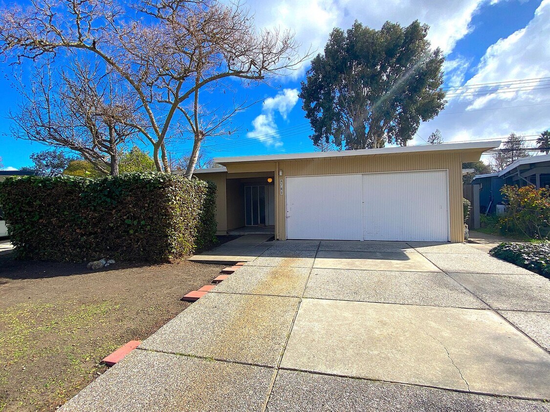
3785 Starr King Cir

Favorites
Check Back Soon for Upcoming Availability
| Beds | Baths | Average SF |
|---|---|---|
| 5 Bedrooms 5 Bedrooms 5 Br | 2.5 Baths 2.5 Baths 2.5 Ba | 1,800 SF |
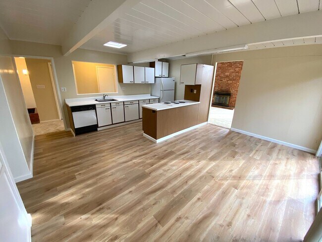
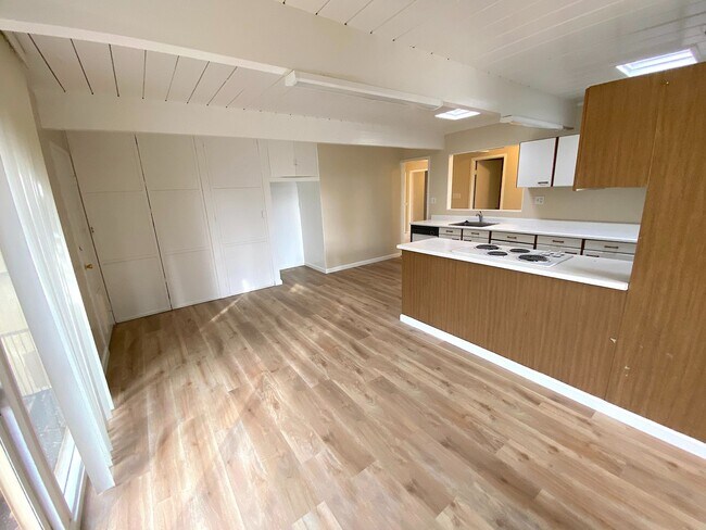
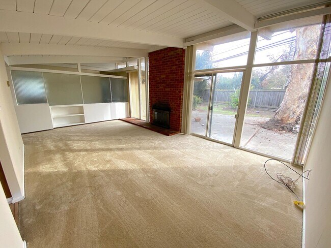
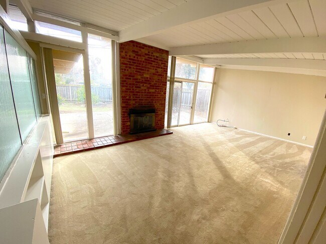
About This Property
This beautiful home offers over 1800 square feet of living space in the centrally located Fairmeadow Palo Alto neighborhood. Large living room featuring a wood-burning fireplace. Large kitchen with abundant cabinet space and storage. Laundry area with washer and dryer included. Well-lit home with large windows. New laminate flooring all throughout. This home is centrally located between Middlefield Road and Alma St with easy access to 101 and San Antonio Rd. In close proximity to dining, shopping and recreational facilities. You'll love the close proximity to Fairmeadow Elementary and Mitchell Park. This wonderful home offers a spacious floor plan with lots of natural light. The house is equipped with forced floor heat. Parking 2-Car Manual Garage Driveway Street Pets None Laundry W/D Included HVAC Forced Floor Heating NO AC Utilities Paid by Tenant Schools(*Tenants to Verify*) Fairmeadow Elementary Jane Lathrop Stanford Middle Henry M. Gunn High If this doesn’t quite meet your needs feel free to view our other available rentals at or give us a call at .
3785 Starr King Cir is a house located in Santa Clara County and the 94306 ZIP Code. This area is served by the Palo Alto Unified attendance zone.
Location
Get Directions
Palo Alto is known as the birthplace of Silicon Valley and that unique heritage is proudly on display, with the Computer History Museum just down the street from Google’s world headquarters and countless other tech companies all over town. The restaurant scene rivals that of nearby San Francisco, with many small, independent eateries serving up some of the best food in the Bay Area.
With close proximity to the country’s tech center, it’s no surprise that Palo Alto apartments come with some of the most incredible amenities around. Residents also have access to dozens of options for outdoor recreation, including the gorgeous hiking and biking trails through the surrounding nature preserves, several golf courses, and easy access to San Francisco Bay. Bicycling is a popular mode of transportation around Palo Alto, with many bike-friendly routes around the city.
Palo Alto is famous as the home of Stanford University, and the campus is one of the most dominant landmarks in the area.
Learn more about living in Palo Alto
Education
| Colleges & Universities | Distance | ||
|---|---|---|---|
| Colleges & Universities | Distance | ||
| Walk: | 15 min | 0.8 mi | |
| Drive: | 10 min | 3.5 mi | |
| Drive: | 12 min | 4.9 mi | |
| Drive: | 13 min | 5.7 mi |
3785 Starr King Cir is within 15 minutes or 0.8 mile from Foothill College, Middlefield. It is also near Stanford University and Foothill Coll., Los Altos.
Schools


Public Elementary School
Grades K-5
367 Students
Nearby
Public Elementary School
Grades K-5
403 Students
Attendance Zone
Public Middle School
Grades 6-8
996 Students
Attendance Zone
Public High School
Grades 9-12
1,787 Students
Attendance Zone
Private Elementary, Middle & High School
Grades K-12
Nearby
Private Elementary & Middle School
Grades PK-8
Nearby
Private Elementary School
Grades PK-5
Nearby
School data provided by
 The GreatSchools Rating helps parents compare schools within a state based on a variety of school quality indicators and provides a helpful picture of how effectively each school serves all of its students. Ratings are on a scale of 1 (below average) to 10 (above average) and can include test scores, college readiness, academic progress, advanced courses, equity, discipline and attendance data. We also advise parents to visit schools, consider other information on school performance and programs, and consider family needs as part of the school selection process.
View GreatSchools Rating Methodology
Data provided by GreatSchools.org © 2025. All rights reserved.
View GreatSchools Rating Methodology
Data provided by GreatSchools.org © 2025. All rights reserved.
Transportation options available in Palo Alto include Mountain View Station, located 2.8 miles from 3785 Starr King Cir. 3785 Starr King Cir is near Norman Y Mineta San Jose International, located 11.9 miles or 18 minutes away, and San Francisco International, located 23.7 miles or 32 minutes away.
| Transit / Subway | Distance | ||
|---|---|---|---|
| Transit / Subway | Distance | ||
| Drive: | 5 min | 2.8 mi | |
|
|
Drive: | 5 min | 2.8 mi |
|
|
Drive: | 8 min | 4.0 mi |
| Drive: | 8 min | 4.4 mi | |
|
|
Drive: | 9 min | 4.5 mi |
| Commuter Rail | Distance | ||
|---|---|---|---|
| Commuter Rail | Distance | ||
| Drive: | 3 min | 1.4 mi | |
| Drive: | 4 min | 2.0 mi | |
| Drive: | 5 min | 2.3 mi | |
| Drive: | 8 min | 3.3 mi | |
| Drive: | 9 min | 3.5 mi |
| Airports | Distance | ||
|---|---|---|---|
| Airports | Distance | ||
|
Norman Y Mineta San Jose International
|
Drive: | 18 min | 11.9 mi |
|
San Francisco International
|
Drive: | 32 min | 23.7 mi |
Time and distance from 3785 Starr King Cir.
| Shopping Centers | Distance | ||
|---|---|---|---|
| Shopping Centers | Distance | ||
| Walk: | 10 min | 0.5 mi | |
| Walk: | 10 min | 0.6 mi | |
| Drive: | 3 min | 1.1 mi |
3785 Starr King Cir has 3 shopping centers within 1.1 miles, which is about a 3-minute walk. The miles and minutes will be for the farthest away property.
| Parks and Recreation | Distance | ||
|---|---|---|---|
| Parks and Recreation | Distance | ||
|
J. Pearce Mitchell Park
|
Walk: | 14 min | 0.7 mi |
|
Terman Park
|
Drive: | 4 min | 1.3 mi |
|
Bol Park
|
Drive: | 5 min | 2.0 mi |
|
Esther Clark Nature Preserve
|
Drive: | 6 min | 2.3 mi |
|
Rinconada Park
|
Drive: | 8 min | 3.2 mi |
3785 Starr King Cir has 5 parks within 3.2 miles, including J. Pearce Mitchell Park, Terman Park, and Bol Park.
| Hospitals | Distance | ||
|---|---|---|---|
| Hospitals | Distance | ||
| Drive: | 10 min | 4.1 mi | |
| Drive: | 12 min | 4.7 mi | |
| Drive: | 11 min | 4.7 mi |
3785 Starr King Cir has 3 hospitals within 4.7 miles, the nearest is Lucile Salter Packard Children's Hospital at Stanford which is 4.1 miles away and a 10 minute drive.
| Military Bases | Distance | ||
|---|---|---|---|
| Military Bases | Distance | ||
| Drive: | 11 min | 4.8 mi |
3785 Starr King Cir is 4.8 miles and a 11 minute drive from Ames Research Center.
You May Also Like
Similar Rentals Nearby


What Are Walk Score®, Transit Score®, and Bike Score® Ratings?
Walk Score® measures the walkability of any address. Transit Score® measures access to public transit. Bike Score® measures the bikeability of any address.
What is a Sound Score Rating?
A Sound Score Rating aggregates noise caused by vehicle traffic, airplane traffic and local sources
3785 Starr King Cir
Palo Alto, CA 94306