

$2,095
/ Month
3646 Silver Oaks Way
Livermore, CA 94550
2 Weeks Ago
|
Edit
Favorites
3646 Silver Oaks Way

Favorites
Check Back Soon for Upcoming Availability
| Beds | Baths | Average SF |
|---|---|---|
| 2 Bedrooms 2 Bedrooms 2 Br | 2 Baths 2 Baths 2 Ba | 850 SF |
About This Property
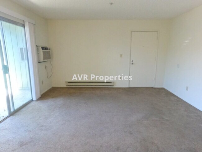
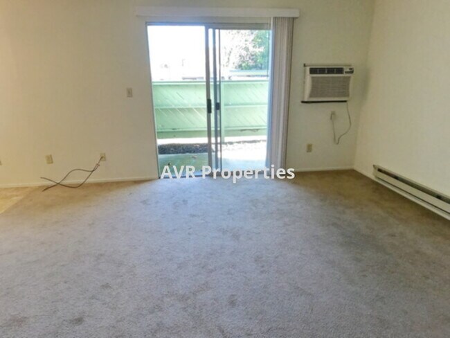
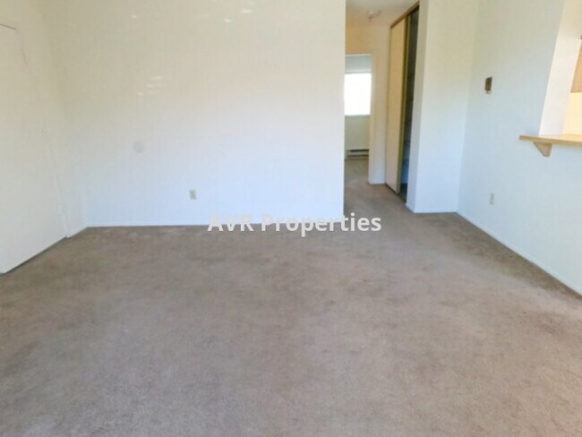
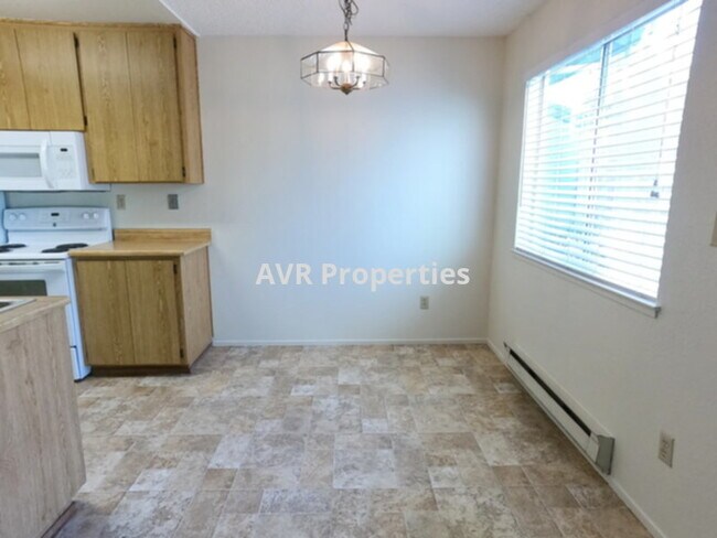
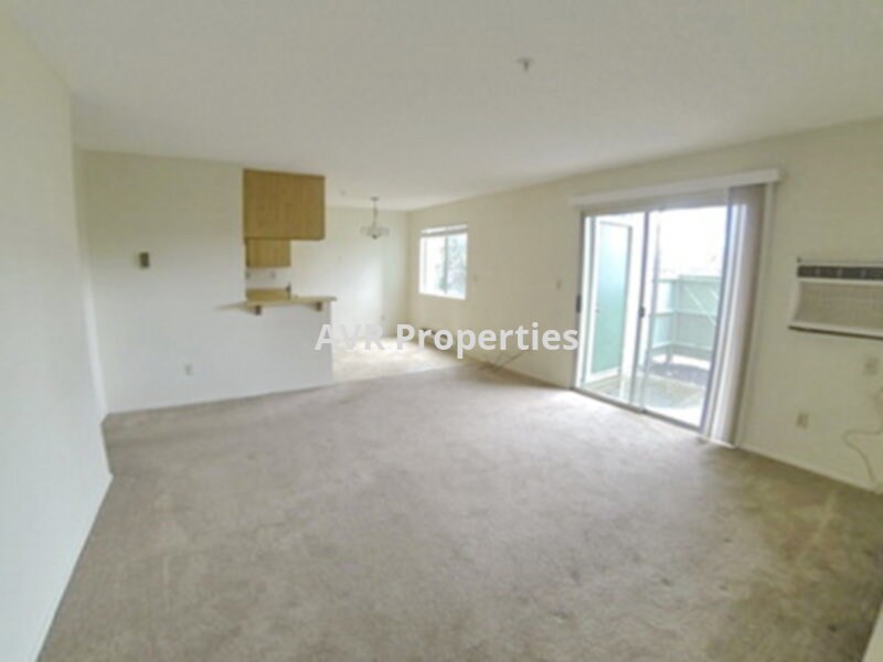
Ground floor Livermore home with two bedrooms, two full bathrooms, new kitchen counters to be installed shortly, new interior paint, washer and dryer inside one of two hall closets, and a full galley style kitchen. This home has a wonderful floor-plan which gives extra space to the living room and bedrooms. Bedroom closets are wide and floor to ceiling. The washer and dryer are provided. The kitchen has a fridge, oven, microwave and dishwasher with a dining area close to the balcony. There is a bonus storage closet on the balcony. The HOA has a pool, tennis court (currently with basketball hoop), and a playground with a picnic table. One small non-aggressive pet under 35 pounds is negotiable with increased deposit. Trash and HOA monthly dues are included in rent. Broker co-op 00960461 AVR Properties.
3646 Silver Oaks Way is a house located in Alameda County and the 94550 ZIP Code. This area is served by the Livermore Valley Joint Unified School District attendance zone.
3646 Silver Oaks Way,
Livermore,
CA
94550
Located in California's wine country, Livermore combines scientific innovation with small-town charm. The city houses the Lawrence Livermore National Laboratory and Sandia National Laboratories, reflecting its evolution from agricultural roots. Current rental rates average $2,278 for one-bedroom apartments. The walkable downtown district along First Street features local shops and restaurants, while South Livermore Valley showcases over 40 wineries, including Wente Vineyards and Concannon Vineyard - both pioneering establishments from the 1880s that helped establish California's wine industry.
The Livermore Area Recreation and Park District maintains 1,842 acres of parks and open spaces, including Sycamore Grove Park and Robertson Park, offering trails and recreational facilities. The Mediterranean climate creates ideal conditions for outdoor activities and wine growing.
Learn more about living in LivermoreBelow are rent ranges for similar nearby apartments
Education
| Colleges & Universities | Distance | ||
|---|---|---|---|
| Colleges & Universities | Distance | ||
| Drive: | 11 min | 4.9 mi | |
| Drive: | 21 min | 13.5 mi | |
| Drive: | 21 min | 13.8 mi | |
| Drive: | 27 min | 17.3 mi |
3646 Silver Oaks Way is within 11 minutes or 4.9 miles from Las Positas College. It is also near Diablo Valley Coll, San Ramon and San Joaquin Delta, Mtn. House.
Schools


Public Elementary School
Grades K-5
Nearby
Public Elementary School
Grades K-5
Attendance Zone
Public Middle School
Grades 6-8
Attendance Zone
Public High School
Grades 9-12
Attendance Zone
Private Elementary School
Grades PK-5
Nearby
Private Elementary, Middle & High School
Grades K-12
Nearby
Private Elementary & Middle School
Grades K-8
Nearby
School data provided by
 The GreatSchools Rating helps parents compare schools within a state based on a variety of school quality indicators and provides a helpful picture of how effectively each school serves all of its students. Ratings are on a scale of 1 (below average) to 10 (above average) and can include test scores, college readiness, academic progress, advanced courses, equity, discipline and attendance data. We also advise parents to visit schools, consider other information on school performance and programs, and consider family needs as part of the school selection process.
View GreatSchools Rating Methodology
Data provided by GreatSchools.org © 2026. All rights reserved.
View GreatSchools Rating Methodology
Data provided by GreatSchools.org © 2026. All rights reserved.
Transportation options available in Livermore include Dublin Pleasanton Station, located 10.3 miles from 3646 Silver Oaks Way. 3646 Silver Oaks Way is near Metro Oakland International, located 29.1 miles or 38 minutes away, and Norman Y Mineta San Jose International, located 32.3 miles or 45 minutes away.
| Transit / Subway | Distance | ||
|---|---|---|---|
| Transit / Subway | Distance | ||
|
|
Drive: | 15 min | 10.3 mi |
|
|
Drive: | 15 min | 10.7 mi |
| Commuter Rail | Distance | ||
|---|---|---|---|
| Commuter Rail | Distance | ||
| Walk: | 12 min | 0.6 mi | |
| Drive: | 9 min | 4.1 mi | |
| Drive: | 15 min | 7.9 mi | |
| Drive: | 34 min | 21.4 mi | |
| Drive: | 34 min | 21.4 mi |
| Airports | Distance | ||
|---|---|---|---|
| Airports | Distance | ||
|
Metro Oakland International
|
Drive: | 38 min | 29.1 mi |
|
Norman Y Mineta San Jose International
|
Drive: | 45 min | 32.3 mi |
Walkability Near 3646 Silver Oaks Way Livermore, CA 94550
Getting Around
 What do Walkability, Transit, Drivability, and Bikeability mean?
Walkability measures the walking distance to day-to-day needs.
Transit measures access to public transportation.
Drivability measures congestion, parking availability, and access to major roads.
Bikeability measures the suitability for cycling.
How It Works
What do Walkability, Transit, Drivability, and Bikeability mean?
Walkability measures the walking distance to day-to-day needs.
Transit measures access to public transportation.
Drivability measures congestion, parking availability, and access to major roads.
Bikeability measures the suitability for cycling.
How It Works
Somewhat Walkable
Walkability
30
/ 100
Some Public Transit
Transit
40
/ 100
Very Drivable
Drivability
80
/ 100
Fairly Bikeable
Bikeability
50
/ 100
Scores provided by
-
Soundscore™
-
/ 100
Traffic
-Airport
-Businesses
-Scores provided by
HowLoud What is a Sound Score Rating? A Sound Score Rating aggregates noise caused by vehicle traffic, airplane traffic and local sources. How It WorksTime and distance from 3646 Silver Oaks Way.
| Shopping Centers | Distance | ||
|---|---|---|---|
| Shopping Centers | Distance | ||
| Walk: | 12 min | 0.6 mi | |
| Drive: | 4 min | 1.2 mi | |
| Drive: | 4 min | 1.5 mi |
3646 Silver Oaks Way has 3 shopping centers within 1.5 miles, which is about a 4-minute drive. The miles and minutes will be for the farthest away property.
| Parks and Recreation | Distance | ||
|---|---|---|---|
| Parks and Recreation | Distance | ||
|
Shadow Cliffs Regional Recreation Area
|
Drive: | 12 min | 5.5 mi |
|
Brushy Peak Regional Preserve
|
Drive: | 14 min | 6.6 mi |
|
Los Vaqueros Watershed
|
Drive: | 15 min | 8.1 mi |
|
Del Valle Regional Park
|
Drive: | 26 min | 8.9 mi |
|
Carnegie State Vehicle Recreation Area
|
Drive: | 23 min | 12.1 mi |
3646 Silver Oaks Way has 5 parks within 12.1 miles, including Shadow Cliffs Regional Recreation Area, Brushy Peak Regional Preserve, and Los Vaqueros Watershed.
| Hospitals | Distance | ||
|---|---|---|---|
| Hospitals | Distance | ||
| Drive: | 13 min | 8.5 mi |
3646 Silver Oaks Way is 8.5 miles and a 13 minute drive from Stanford Health Care - ValleyCare.
You May Also Like
Similar Rentals Nearby


What Are Walk Score®, Transit Score®, and Bike Score® Ratings?
Walk Score® measures the walkability of any address. Transit Score® measures access to public transit. Bike Score® measures the bikeability of any address.
What is a Sound Score Rating?
A Sound Score Rating aggregates noise caused by vehicle traffic, airplane traffic and local sources.
3646 Silver Oaks Way
Livermore, CA 94550