


$3,036
/ Month
363 E Airy St
Norristown, PA 19401
Today
|
Edit
Favorites
610-275-2050
-
Bedrooms
4
-
Bathrooms
2
-
Square Feet
2,520 sq ft
-
Available
Available Dec 29
Highlight
- Basement
363 E Airy St

Favorites
About This Home
Available Dec 29
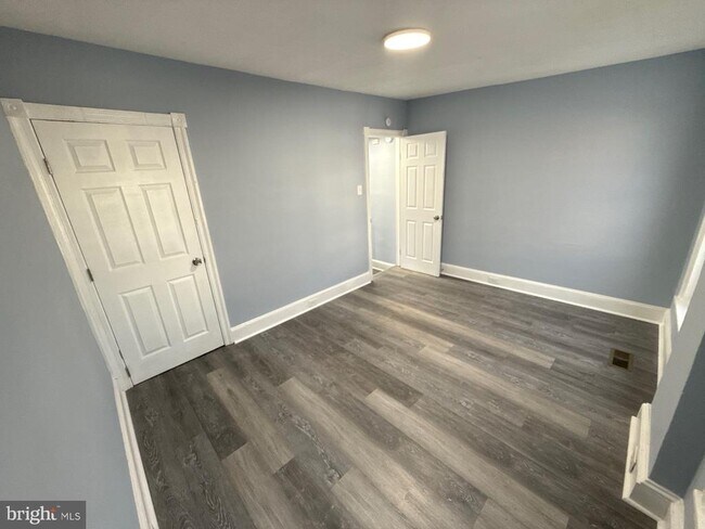
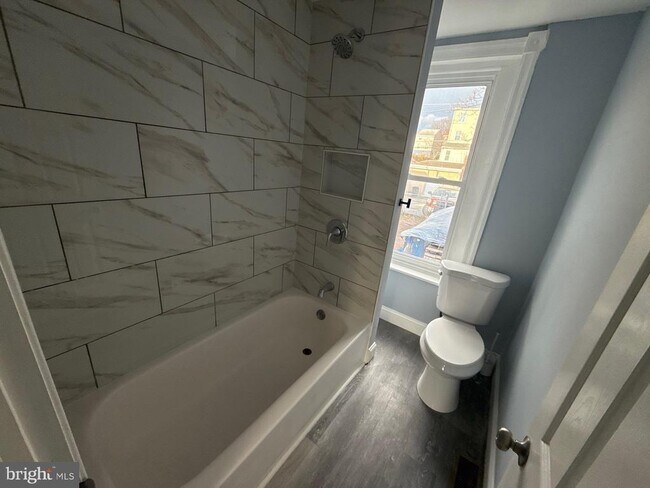
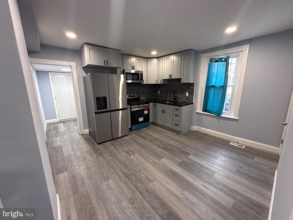
Newly-renovated, 3-story row on Norristown's east end. Beautiful, large, eat-in kitchen with granite countertops and stainless steel appliances. 4 bedrooms, 2 full bathrooms (including large first floor bath.) New paint and new luxury vinyl plank flooring throughout. Back yard for entertaining, 2-car off-street parking in rear. Walking distance to public transportation including regional rail, metro high-speed line, and buses. Easy access to local and regional shopping centers. Section-8 approved.
363 E Airy St is a townhome located in Montgomery County and the 19401 ZIP Code. This area is served by the Norristown Area attendance zone.
* Price shown is base rent. Excludes user-selected optional fees and variable or usage-based fees and required charges due at or prior to move-in or at move-out. Price, availability, fees, and any applicable rent special are subject to change without notice.
* Square footage definitions vary. Displayed square footage is approximate.
Townhome Features
- Basement
Contact
- Listed by Donna Moles | Charles L. Moles Real Estate, LLC
- Phone Number
- Contact
-
Source
 Bright MLS, Inc.
Copyright © 2025 Bright MLS, Inc.
Location
Get Directions
Amenities
- Basement
Norristown is a suburban community that really is close to everything: Philadelphia is only about 45 minutes away by car, and SEPTA rail service is available from multiple stations around town. In addition to the convenient proximity to the big city, Valley Forge National Historic Park and King of Prussia Mall are practically right next door.
Closer to home, Main Street and Marshall Street are home to several locally-owned shops and restaurants in an attractive, walkable setting, with many historic buildings nearby as well. Attractions such as Elmwood Park Zoo and large parks like Norristown Farm give residents plenty of opportunities to enjoy time outdoors, right in their own backyard.
Learn more about living in Norristown
Education
| Colleges & Universities | Distance | ||
|---|---|---|---|
| Colleges & Universities | Distance | ||
| Drive: | 15 min | 6.5 mi | |
| Drive: | 17 min | 6.9 mi | |
| Drive: | 16 min | 7.1 mi | |
| Drive: | 19 min | 9.3 mi |
363 E Airy St is within 17 minutes or 6.9 miles from Cabrini College. It is also near Montgomery Co. C.C., Central and Eastern University.
Schools


Public Elementary School
Grades K-4
452 Students
Attendance Zone
Public Elementary & Middle School
Grades 5-8
864 Students
Attendance Zone
Public Elementary School
Grades K-4
266 Students
Nearby
Public High School
Grades 9-12
2,309 Students
Attendance Zone
Private Elementary & Middle School
Grades K-8
Nearby
Private Elementary & Middle School
Grades 5-9
Nearby
Private Elementary School
Grades PK-3 & 5
69 Students
Nearby
Private High School
Grades 9-12
403 Students
Nearby
School data provided by
 The GreatSchools Rating helps parents compare schools within a state based on a variety of school quality indicators and provides a helpful picture of how effectively each school serves all of its students. Ratings are on a scale of 1 (below average) to 10 (above average) and can include test scores, college readiness, academic progress, advanced courses, equity, discipline and attendance data. We also advise parents to visit schools, consider other information on school performance and programs, and consider family needs as part of the school selection process.
View GreatSchools Rating Methodology
Data provided by GreatSchools.org © 2025. All rights reserved.
View GreatSchools Rating Methodology
Data provided by GreatSchools.org © 2025. All rights reserved.
Transportation options available in Norristown include Norristown Transportation Center (100 Line), located 0.7 mile from 363 E Airy St. 363 E Airy St is near Philadelphia International, located 27.1 miles or 43 minutes away, and Trenton Mercer, located 38.0 miles or 53 minutes away.
| Transit / Subway | Distance | ||
|---|---|---|---|
| Transit / Subway | Distance | ||
|
|
Walk: | 12 min | 0.7 mi |
|
|
Drive: | 5 min | 1.5 mi |
|
|
Drive: | 4 min | 1.6 mi |
|
|
Drive: | 8 min | 3.0 mi |
|
|
Drive: | 10 min | 4.6 mi |
| Commuter Rail | Distance | ||
|---|---|---|---|
| Commuter Rail | Distance | ||
|
|
Walk: | 10 min | 0.6 mi |
|
|
Walk: | 17 min | 0.9 mi |
|
|
Walk: | 22 min | 1.2 mi |
|
|
Drive: | 10 min | 4.2 mi |
| Drive: | 11 min | 4.3 mi |
| Airports | Distance | ||
|---|---|---|---|
| Airports | Distance | ||
|
Philadelphia International
|
Drive: | 43 min | 27.1 mi |
|
Trenton Mercer
|
Drive: | 53 min | 38.0 mi |
Time and distance from 363 E Airy St.
| Shopping Centers | Distance | ||
|---|---|---|---|
| Shopping Centers | Distance | ||
| Walk: | 7 min | 0.4 mi | |
| Walk: | 10 min | 0.5 mi | |
| Walk: | 13 min | 0.7 mi |
363 E Airy St has 3 shopping centers within 0.7 mile, which is about a 13-minute walk. The miles and minutes will be for the farthest away property.
| Parks and Recreation | Distance | ||
|---|---|---|---|
| Parks and Recreation | Distance | ||
|
Elmwood Park Zoo
|
Drive: | 5 min | 1.9 mi |
|
Norristown Farm Park
|
Drive: | 9 min | 4.0 mi |
|
McKaig Nature Education Center
|
Drive: | 11 min | 5.1 mi |
|
Henry Botanic Garden
|
Drive: | 15 min | 6.3 mi |
|
Riverbend Environmental Education Center
|
Drive: | 16 min | 6.5 mi |
363 E Airy St has 5 parks within 6.5 miles, including Elmwood Park Zoo, Norristown Farm Park, and McKaig Nature Education Center.
| Hospitals | Distance | ||
|---|---|---|---|
| Hospitals | Distance | ||
| Drive: | 5 min | 1.8 mi | |
| Drive: | 6 min | 2.4 mi | |
| Drive: | 9 min | 2.7 mi |
363 E Airy St has 3 hospitals within 2.7 miles, the nearest is Norristown State Hospital which is 1.8 miles away and a 5 minute drive.
| Military Bases | Distance | ||
|---|---|---|---|
| Military Bases | Distance | ||
| Drive: | 27 min | 17.0 mi |
363 E Airy St is 17.0 miles and a 27 minute drive from Willow Grove Naval Air Station.
You May Also Like
Similar Rentals Nearby


What Are Walk Score®, Transit Score®, and Bike Score® Ratings?
Walk Score® measures the walkability of any address. Transit Score® measures access to public transit. Bike Score® measures the bikeability of any address.
What is a Sound Score Rating?
A Sound Score Rating aggregates noise caused by vehicle traffic, airplane traffic and local sources
363 E Airy St
Norristown, PA 19401