
The Ellington
101 Eastline Rd,
Searcy, AR 72143
$900 - $1,325
Studio - 2 Beds


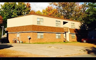
Experience Searcy living at 36 Stoneybrook Ln. These apartments are located in Searcy on Stoneybrook Ln. in the 72143 area. Make a visit to see the current floorplan options. Here at this community, the leasing team is excited to help you find your perfect new apartment. Experience a new standard at 36 Stoneybrook Ln.
36 Stoneybrook Ln is an apartment community located in White County and the 72143 ZIP Code. This area is served by the Searcy County School District attendance zone.
Searcy is a small city positioned about fifty miles northeast of Little Rock on Highway 67. The community is perhaps best known as the home of Harding University, a private institution which enrolls around 6,000 students and employs hundreds of locals as faculty and staff members.
On top of the numerous public parks throughout the city, locals enjoy close access to huge nature preserves like Bald Knob Refuge and Henry Gray Hurricane Lake, providing great opportunities for hiking, camping, and hunting just east of town. Rental rates in town tend to be quite affordable, with terrific options available to fit any budget or lifestyle.
Learn more about living in Searcy| Colleges & Universities | Distance | ||
|---|---|---|---|
| Colleges & Universities | Distance | ||
| Drive: | 7 min | 2.9 mi |


Scores provided by
Traffic
ActiveAirport
CalmBusinesses
CalmScores provided by
HowLoud What is a Sound Score Rating? A Sound Score Rating aggregates noise caused by vehicle traffic, airplane traffic and local sources. How It WorksWhat Are Walk Score®, Transit Score®, and Bike Score® Ratings?
Walk Score® measures the walkability of any address. Transit Score® measures access to public transit. Bike Score® measures the bikeability of any address.
What is a Sound Score Rating?
A Sound Score Rating aggregates noise caused by vehicle traffic, airplane traffic and local sources.
36 Stoneybrook Ln
Searcy, AR 72143


