

$5,700 / Month
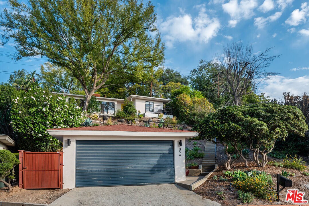
356 Cherry Dr
Pasadena, CA 91105
2 Weeks Ago
Favorites
356 Cherry Dr

Favorites
Check Back Soon for Upcoming Availability
| Beds | Baths | Average SF |
|---|---|---|
| 2 Bedrooms 2 Bedrooms 2 Br | 2 Baths 2 Baths 2 Ba | 1,268 SF |
About This Property
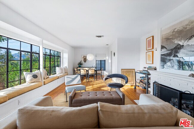
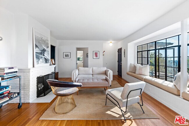
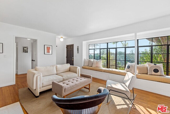
Charming and spacious 2 BR+2 BA traditional home perched on top of the San Rafael Hills. Boasting stunning views facing West towards the San Gabriel Mountains and the city lights of Eagle Rock and Glendale. The home has an abundance of natural light throughout. Open living and dining area with hardwood floors, brick fireplace and wall to wall glass windows with built-in bench. Updated kitchen with granite countertops and stainless steel appliances. Two generously sized bedrooms with ample closet space. Both bathrooms recently updated with tile floors and new countertops. Bonus room/den includes a fireplace and French doors leading out to the large private backyard, perfect for al fresco dining. Laundry room with washer and dryer. Two-car garage. Would make a wonderful place to call home!
356 Cherry Dr is a house located in Los Angeles County and the 91105 ZIP Code. This area is served by the Pasadena Unified attendance zone.
House Features
Dishwasher
Washer/Dryer Hookup
Hardwood Floors
Refrigerator
- Washer/Dryer Hookup
- Dishwasher
- Refrigerator
- Hardwood Floors
- Dining Room
- Views
Location
Get Directions
Annandale is nestled in a quaint, high-end section of Pasadena in the outskirts of Los Angeles. Many visitors pass through Annandale to cross the landmark Colorado Street Bridge or exit the Ventura Freeway heading to events at the Rose Bowl. The neighborhood contains mostly million-dollar homes and grand estates, along with a few upscale rental properties. The only commercial zone rests along Colorado Boulevard, comprising of a few small businesses. The Arroyo Seco defines the eastern border, a dry riverbed that extends from the San Gabriel Mountains down to Elysian Park. Annandale sits only two miles west of Pasadena City Hall and nine miles northeast of Downtown Los Angeles.
Learn more about living in AnnandaleBelow are rent ranges for similar nearby apartments
Amenities
- Washer/Dryer Hookup
- Dishwasher
- Refrigerator
- Hardwood Floors
- Dining Room
- Views
Education
| Colleges & Universities | Distance | ||
|---|---|---|---|
| Colleges & Universities | Distance | ||
| Drive: | 7 min | 3.3 mi | |
| Drive: | 8 min | 3.5 mi | |
| Drive: | 8 min | 3.8 mi | |
| Drive: | 9 min | 3.8 mi |
356 Cherry Dr is within 8 minutes or 3.5 miles from Occidental College. It is also near Art Center College of Design and Fuller Theological Seminary.
Schools

Charter Elementary School
Grades K-5
75 Students
Nearby
Public Elementary School
Grades K-5
385 Students
Attendance Zone
Public Middle & High School
Grades 6-12
1,117 Students
Attendance Zone
Private Elementary & Middle School
Grades PK-8
237 Students
Nearby
Private Elementary, Middle & High School
Grades 1-12
71 Students
Nearby
Private Middle & High School
Grades 6-12
39 Students
Nearby
School data provided by
 The GreatSchools Rating helps parents compare schools within a state based on a variety of school quality indicators and provides a helpful picture of how effectively each school serves all of its students. Ratings are on a scale of 1 (below average) to 10 (above average) and can include test scores, college readiness, academic progress, advanced courses, equity, discipline and attendance data. We also advise parents to visit schools, consider other information on school performance and programs, and consider family needs as part of the school selection process.
View GreatSchools Rating Methodology
Data provided by GreatSchools.org © 2025. All rights reserved.
View GreatSchools Rating Methodology
Data provided by GreatSchools.org © 2025. All rights reserved.
Transportation options available in Pasadena include Highland Park Station, located 2.5 miles from 356 Cherry Dr. 356 Cherry Dr is near Bob Hope, located 15.4 miles or 22 minutes away, and Los Angeles International, located 22.7 miles or 37 minutes away.
| Transit / Subway | Distance | ||
|---|---|---|---|
| Transit / Subway | Distance | ||
|
|
Drive: | 7 min | 2.5 mi |
|
|
Drive: | 5 min | 2.6 mi |
|
|
Drive: | 6 min | 2.6 mi |
|
|
Drive: | 7 min | 2.7 mi |
|
|
Drive: | 7 min | 3.3 mi |
| Commuter Rail | Distance | ||
|---|---|---|---|
| Commuter Rail | Distance | ||
|
|
Drive: | 15 min | 7.6 mi |
|
|
Drive: | 17 min | 7.7 mi |
|
|
Drive: | 12 min | 7.9 mi |
|
|
Drive: | 15 min | 10.0 mi |
| Drive: | 18 min | 11.7 mi |
| Airports | Distance | ||
|---|---|---|---|
| Airports | Distance | ||
|
Bob Hope
|
Drive: | 22 min | 15.4 mi |
|
Los Angeles International
|
Drive: | 37 min | 22.7 mi |
Time and distance from 356 Cherry Dr.
| Shopping Centers | Distance | ||
|---|---|---|---|
| Shopping Centers | Distance | ||
| Drive: | 4 min | 1.6 mi | |
| Drive: | 4 min | 1.8 mi | |
| Drive: | 5 min | 2.0 mi |
356 Cherry Dr has 3 shopping centers within 2.0 miles, which is about a 5-minute drive. The miles and minutes will be for the farthest away property.
| Parks and Recreation | Distance | ||
|---|---|---|---|
| Parks and Recreation | Distance | ||
|
Kidspace Children's Museum
|
Drive: | 6 min | 2.4 mi |
|
Audubon Center at Debs Park
|
Drive: | 8 min | 3.7 mi |
|
Jet Propulsion Laboratory
|
Drive: | 9 min | 5.1 mi |
|
Huntington Botanical Gardens
|
Drive: | 13 min | 5.6 mi |
|
Elyria Canyon Park
|
Drive: | 13 min | 5.9 mi |
356 Cherry Dr has 5 parks within 5.9 miles, including Kidspace Children's Museum, Audubon Center at Debs Park, and Jet Propulsion Laboratory.
| Hospitals | Distance | ||
|---|---|---|---|
| Hospitals | Distance | ||
| Drive: | 6 min | 2.1 mi | |
| Drive: | 9 min | 4.5 mi | |
| Drive: | 13 min | 5.2 mi |
356 Cherry Dr has 3 hospitals within 5.2 miles, the nearest is Huntington Memorial Hospital which is 2.1 miles away and a 6 minute drive.
| Military Bases | Distance | ||
|---|---|---|---|
| Military Bases | Distance | ||
| Drive: | 34 min | 24.2 mi | |
| Drive: | 47 min | 31.7 mi |
356 Cherry Dr is 24.2 miles from Los Angeles Air Force Base, and is convenient to other military bases, including Los Alamitos Army Airfield.
You May Also Like
Similar Rentals Nearby


What Are Walk Score®, Transit Score®, and Bike Score® Ratings?
Walk Score® measures the walkability of any address. Transit Score® measures access to public transit. Bike Score® measures the bikeability of any address.
What is a Sound Score Rating?
A Sound Score Rating aggregates noise caused by vehicle traffic, airplane traffic and local sources

356 Cherry Dr
Pasadena, CA 91105