
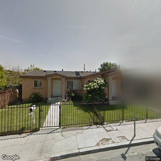
350 W Fig St
350 W Fig St
Compton, CA 90222
Favorites
350 W Fig St

Favorites
Check Back Soon for Upcoming Availability
| Beds | Baths | Average SF |
|---|---|---|
| 1 Bedroom 1 Bedroom 1 Br | 1 Bath 1 Bath 1 Ba | 800 SF |
| 2 Bedrooms 2 Bedrooms 2 Br | 1 Bath 1 Bath 1 Ba | 800 SF |
Fees and Policies
Details
Property Information
-
3 units
350 W Fig St,
Compton,
CA
90222
Sitting at the geographic heart of Los Angeles County, Compton earned its nickname the "Hub City" for good reason — freeways like the I-710 and I-105 put Downtown LA and the coastline within easy reach. Daily life here moves at a steady pace, with local parks, neighborhood markets, and community gathering spots woven throughout the city's 11 square miles. Long considered one of the county's most accessible suburbs, Compton has steadily grown into a go-to destination for entrepreneurs and those who want the pulse of LA without the premium price tag.
Compton's housing stock offers everything from garden-style apartment communities to spacious multi-bedroom rentals. One of the oldest incorporated cities in Los Angeles County, dating back to 1888, Compton carries serious cultural weight — it's produced a remarkable roster of artists, including Kendrick Lamar and Dr. Dre, whose influence on music echoes worldwide.
Learn more about living in ComptonBelow are rent ranges for similar nearby apartments
Education
| Colleges & Universities | Distance | ||
|---|---|---|---|
| Colleges & Universities | Distance | ||
| Drive: | 7 min | 2.9 mi | |
| Drive: | 10 min | 4.7 mi | |
| Drive: | 13 min | 6.4 mi | |
| Drive: | 12 min | 6.6 mi |
350 W Fig St is within 7 minutes or 2.9 miles from El Camino College, Compton. It is also near Cal State Dominguez Hills and Los Angeles Southwest College.
Transportation options available in Compton include Compton Station, located 1.3 miles from 350 W Fig St. 350 W Fig St is near Long Beach (Daugherty Field), located 10.4 miles or 19 minutes away, and Los Angeles International, located 13.2 miles or 21 minutes away.
| Transit / Subway | Distance | ||
|---|---|---|---|
| Transit / Subway | Distance | ||
|
|
Walk: | 24 min | 1.3 mi |
|
|
Drive: | 7 min | 2.9 mi |
|
|
Drive: | 6 min | 3.0 mi |
|
|
Drive: | 7 min | 3.5 mi |
|
|
Drive: | 7 min | 3.8 mi |
| Commuter Rail | Distance | ||
|---|---|---|---|
| Commuter Rail | Distance | ||
|
|
Drive: | 20 min | 10.8 mi |
|
|
Drive: | 21 min | 10.9 mi |
|
|
Drive: | 20 min | 11.0 mi |
|
|
Drive: | 23 min | 11.2 mi |
|
|
Drive: | 22 min | 12.3 mi |
| Airports | Distance | ||
|---|---|---|---|
| Airports | Distance | ||
|
Long Beach (Daugherty Field)
|
Drive: | 19 min | 10.4 mi |
|
Los Angeles International
|
Drive: | 21 min | 13.2 mi |
Walkability Near 350 W Fig St Compton, CA 90222
Getting Around
 What do Walkability, Transit, Drivability, and Bikeability mean?
Walkability measures the walking distance to day-to-day needs.
Transit measures access to public transportation.
Drivability measures congestion, parking availability, and access to major roads.
Bikeability measures the suitability for cycling.
How It Works
What do Walkability, Transit, Drivability, and Bikeability mean?
Walkability measures the walking distance to day-to-day needs.
Transit measures access to public transportation.
Drivability measures congestion, parking availability, and access to major roads.
Bikeability measures the suitability for cycling.
How It Works
Fairly Walkable
Walkability
50
/ 100
Some Public Transit
Transit
40
/ 100
Very Drivable
Drivability
80
/ 100
Fairly Bikeable
Bikeability
50
/ 100
Scores provided by
-
Soundscore™
-
/ 100
Traffic
-Airport
-Businesses
-Scores provided by
HowLoud What is a Sound Score Rating? A Sound Score Rating aggregates noise caused by vehicle traffic, airplane traffic and local sources. How It WorksTime and distance from 350 W Fig St.
| Shopping Centers | Distance | ||
|---|---|---|---|
| Shopping Centers | Distance | ||
| Walk: | 9 min | 0.5 mi | |
| Walk: | 14 min | 0.7 mi | |
| Walk: | 15 min | 0.8 mi |
350 W Fig St has 3 shopping centers within 0.8 mile, which is about a 15-minute walk. The miles and minutes will be for the farthest away property.
| Parks and Recreation | Distance | ||
|---|---|---|---|
| Parks and Recreation | Distance | ||
|
Compton Creek Natural Park at George Washington Elementary
|
Walk: | 14 min | 0.8 mi |
|
Watts Towers-Rodia State Park
|
Drive: | 7 min | 3.0 mi |
|
Watts Senior Center & Rose Garden
|
Drive: | 7 min | 3.5 mi |
|
Augustus Hawkins Natural Park
|
Drive: | 12 min | 6.9 mi |
|
California Science Center
|
Drive: | 18 min | 11.8 mi |
350 W Fig St has 5 parks within 11.8 miles, including Compton Creek Natural Park at George Washington Elementary, Watts Towers-Rodia State Park, and Watts Senior Center & Rose Garden.
| Hospitals | Distance | ||
|---|---|---|---|
| Hospitals | Distance | ||
| Drive: | 5 min | 2.1 mi | |
| Drive: | 6 min | 3.3 mi | |
| Drive: | 8 min | 4.6 mi |
350 W Fig St has 3 hospitals within 4.6 miles, the nearest is Martin Luther King, Jr. Community Hospital which is 2.1 miles away and a 5 minute drive.
| Military Bases | Distance | ||
|---|---|---|---|
| Military Bases | Distance | ||
| Drive: | 17 min | 10.0 mi | |
| Drive: | 19 min | 11.0 mi | |
| Drive: | 22 min | 13.8 mi |
350 W Fig St has 3 military bases within 13.8 miles, the nearest is Los Angeles Air Force Base which is 10.0 miles away and a 17 minute drive.
You May Also Like
Similar Rentals Nearby
-
-
-
2 Beds$6,251+3 Beds$4,455+Total Monthly PriceTotal Monthly Price NewPrices include base rent and required monthly fees of $155. Variable costs based on usage may apply.Base Rent:2 Beds$6,095+3 Beds$4,299+3 Months Free
Pets Allowed Fitness Center Dishwasher Kitchen In Unit Washer & Dryer Walk-In Closets
-
-
-
-
-
-
-
1 / 50


What Are Walk Score®, Transit Score®, and Bike Score® Ratings?
Walk Score® measures the walkability of any address. Transit Score® measures access to public transit. Bike Score® measures the bikeability of any address.
What is a Sound Score Rating?
A Sound Score Rating aggregates noise caused by vehicle traffic, airplane traffic and local sources.
350 W Fig St
Compton, CA 90222