

$13,200
/ Month
34405 Pacific Coast Hwy
Malibu, CA 90265
2 Weeks Ago
|
Edit
Favorites
34405 Pacific Coast Hwy

Favorites
Check Back Soon for Upcoming Availability
| Beds | Baths | Average SF |
|---|---|---|
| 4 Bedrooms 4 Bedrooms 4 Br | 3 Baths 3 Baths 3 Ba | 2,989 SF |
About This Property
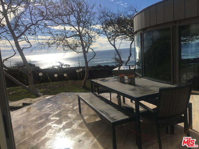
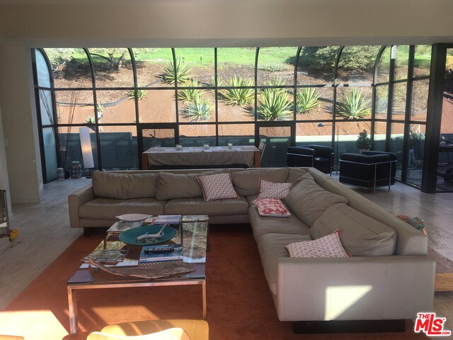
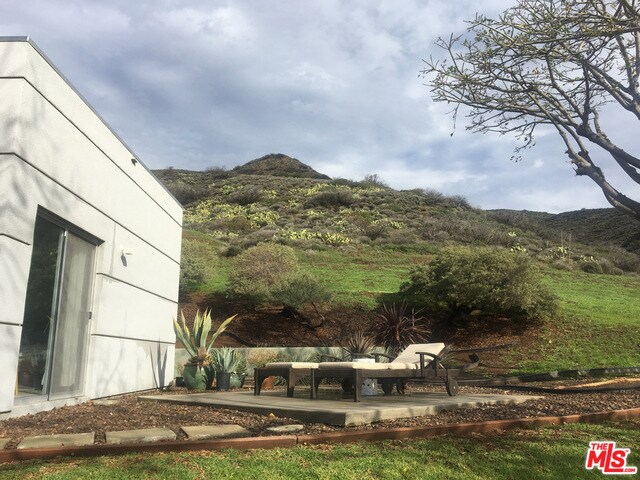
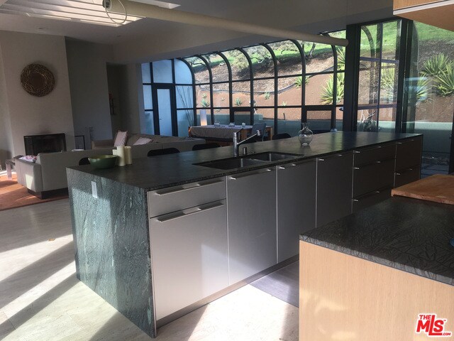
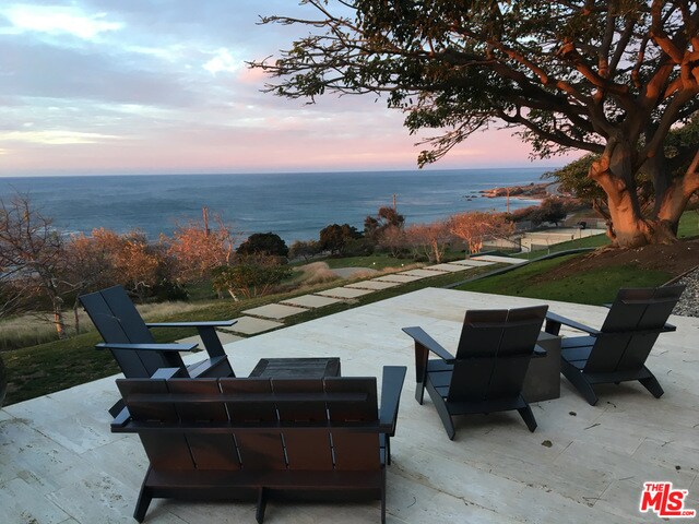
ABSOLUTE SATISFACTION. Your HAVEN, RETREAT - Privacy & Tranquility. The drama of this Ed Niles FAIA home on several acres captivates. Stunning use of Glass, concrete, Steel, & Stone along with superior finishes equals STYLE. Gated drive leads to home with wrap around views of coastline, beach & Mountains. Close to great surfing plus you have your own hiking trails. Surrounded by sycamores, corral trees & Mother Nature; yet close to everything. Sleek, elegant kitchen with some Miele appliances opens to Great Room where you will love to be unless you are outside on one of the patios. Outdoor shower for after beach swim. Spacious rooms throughout. A real home, special and fun. Ready to lease.
34405 Pacific Coast Hwy is a house located in Los Angeles County and the 90265 ZIP Code. This area is served by the Santa Monica-Malibu Unified School District attendance zone.
House Features
Dishwasher
Washer/Dryer Hookup
Walk-In Closets
Freezer
- Washer/Dryer Hookup
- Fireplace
- Dishwasher
- Freezer
- Views
- Walk-In Closets
34405 Pacific Coast Hwy,
Malibu,
CA
90265
Stretched along 21 miles of Pacific coastline with the Santa Monica Mountains at its back, Malibu is one of the few places where you can surf in the morning and hike a canyon trail before lunch. Daily life here revolves around the outdoors — from the rolling breaks at Surfrider Beach to the rugged paths winding through Santa Monica Mountains National Recreation Area. The Malibu Pier and Malibu Lagoon State Beach anchor the Civic Center area, while spots like Point Dume and El Matador offer a quieter escape from the Pacific Coast Highway buzz. Locals call it "The 'Bu," and that nickname says it all — this is a place with its own rhythm.
Rentals in Malibu range from oceanfront condos along Malibu Road to canyon-tucked homes near Latigo and Corral Canyon. Apartment communities here tend toward smaller, well-appointed buildings rather than high-rises, with many offering direct beach access or sweeping mountain views.
Learn more about living in MalibuBelow are rent ranges for similar nearby apartments
Amenities
- Washer/Dryer Hookup
- Fireplace
- Dishwasher
- Freezer
- Views
- Walk-In Closets
Education
| Colleges & Universities | Distance | ||
|---|---|---|---|
| Colleges & Universities | Distance | ||
| Drive: | 22 min | 13.9 mi | |
| Drive: | 24 min | 17.1 mi | |
| Drive: | 23 min | 17.6 mi | |
| Drive: | 38 min | 23.4 mi |
34405 Pacific Coast Hwy is within 22 minutes or 13.9 miles from Pepperdine University. It is also near CSU Channel Islands and Oxnard College.
Schools

Public Elementary, Middle & High School
Grades K-12
231 Students
Nearby
Public Elementary School
Grades K-5
198 Students
Attendance Zone
Public High School
Grades 9-12
387 Students
Attendance Zone
Private Elementary School
Grades PK-5
Nearby
Private Elementary School
Grades K-5
Nearby
School data provided by
 The GreatSchools Rating helps parents compare schools within a state based on a variety of school quality indicators and provides a helpful picture of how effectively each school serves all of its students. Ratings are on a scale of 1 (below average) to 10 (above average) and can include test scores, college readiness, academic progress, advanced courses, equity, discipline and attendance data. We also advise parents to visit schools, consider other information on school performance and programs, and consider family needs as part of the school selection process.
View GreatSchools Rating Methodology
Data provided by GreatSchools.org © 2026. All rights reserved.
View GreatSchools Rating Methodology
Data provided by GreatSchools.org © 2026. All rights reserved.
Walkability Near 34405 Pacific Coast Hwy Malibu, CA 90265
Getting Around
 What do Walkability, Transit, Drivability, and Bikeability mean?
Walkability measures the walking distance to day-to-day needs.
Transit measures access to public transportation.
Drivability measures congestion, parking availability, and access to major roads.
Bikeability measures the suitability for cycling.
How It Works
What do Walkability, Transit, Drivability, and Bikeability mean?
Walkability measures the walking distance to day-to-day needs.
Transit measures access to public transportation.
Drivability measures congestion, parking availability, and access to major roads.
Bikeability measures the suitability for cycling.
How It Works
Not Walkable
Walkability
0
/ 100
Exceptionally Drivable
Drivability
100
/ 100
Fairly Bikeable
Bikeability
40
/ 100
Scores provided by
-
Soundscore™
-
/ 100
Traffic
-Airport
-Businesses
-Scores provided by
HowLoud What is a Sound Score Rating? A Sound Score Rating aggregates noise caused by vehicle traffic, airplane traffic and local sources. How It WorksYou May Also Like
Similar Rentals Nearby
-
-

-

-

-

-

-
 4 Beds, 4 Baths, 4,456 sq ft$39,950Total Monthly PriceTotal Monthly Price NewPrices include all required monthly fees.31654 Broad Beach Rd
 -
 5 Beds, 5 Baths, 3,412 sq ft$49,500Total Monthly PriceTotal Monthly Price NewPrices include all required monthly fees.24608 Malibu Rd
 -
 4 Beds, 4 Baths, 3,256 sq ft$10,500Total Monthly Price12 Month LeaseTotal Monthly Price NewPrices include all required monthly fees.23172 Park Pinta
 -
 5 Beds, 5 Baths, 5,555 sq ft$23,000Total Monthly PriceTotal Monthly Price NewPrices include all required monthly fees.5946 Woodlake Ave
What Are Walk Score®, Transit Score®, and Bike Score® Ratings?
Walk Score® measures the walkability of any address. Transit Score® measures access to public transit. Bike Score® measures the bikeability of any address.
What is a Sound Score Rating?
A Sound Score Rating aggregates noise caused by vehicle traffic, airplane traffic and local sources.
34405 Pacific Coast Hwy
Malibu, CA 90265