

$2,250
/ Month
340 N Livermore Ave
Livermore, CA 94551
Favorites
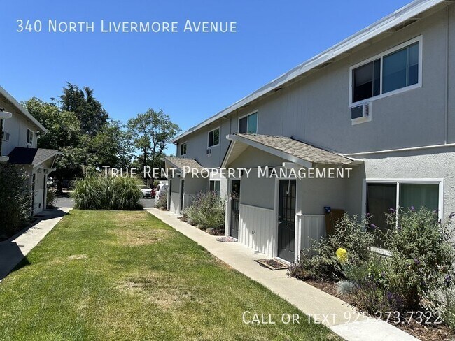
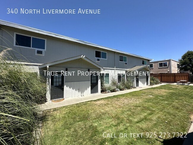
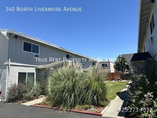
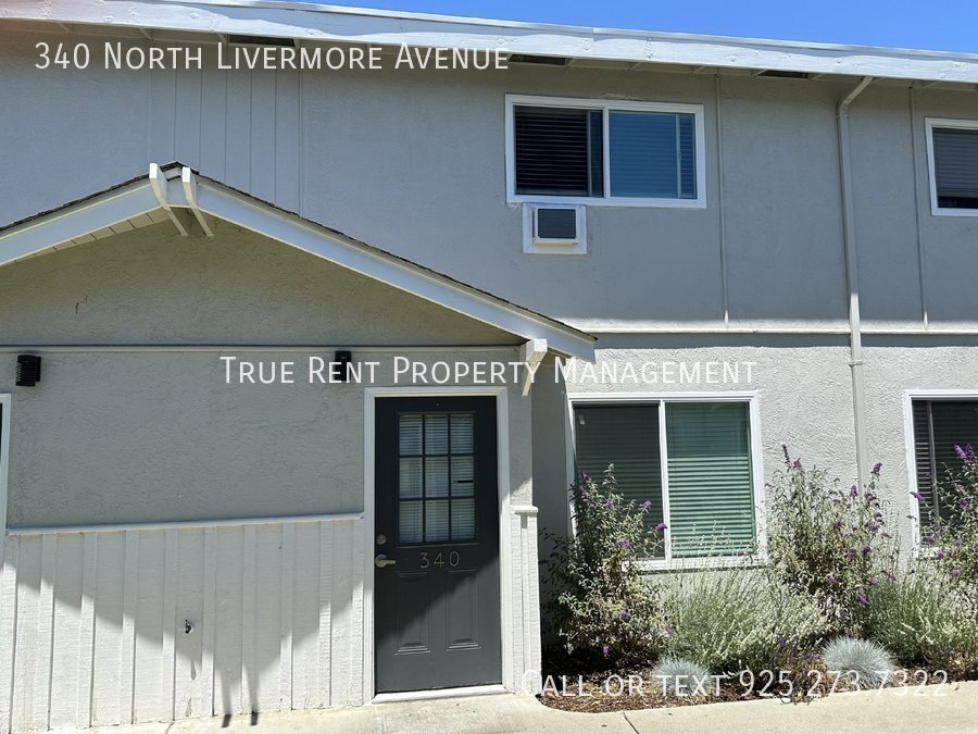
340 N Livermore Ave

Favorites
Check Back Soon for Upcoming Availability
| Beds | Baths | Average SF |
|---|---|---|
| 2 Bedrooms 2 Bedrooms 2 Br | 1.5 Baths 1.5 Baths 1.5 Ba | 894 SF |
About This Property
---- SCHEDULE A SHOWING ONLINE AT: ---- Do not miss out on this well kept 2-story apartment walking distance to Downtown Livermore. This unit is in a 4-plex. This home features a family room, dining area, and kitchen and half bath downstairs. The upstairs features two large bedrooms and a shared full bath. Both bedrooms have wall A/C units. Shared laundry room available onsite for all 4 units in the complex. Private backyard patio area great for grilling. Separate storage and covered parking also available. No Smoking. No pets. Water included in rent. Tenants are responsible for all other utilities including garbage service. Available Now. CA DRE#02047391Walk To Downtown Livermore
340 N Livermore Ave is an apartment community located in Alameda County and the 94551 ZIP Code.
Features
- Air Conditioning
- Disposal
- Refrigerator
340 N Livermore Ave,
Livermore,
CA
94551
Located in California's wine country, Livermore combines scientific innovation with small-town charm. The city houses the Lawrence Livermore National Laboratory and Sandia National Laboratories, reflecting its evolution from agricultural roots. Current rental rates average $2,278 for one-bedroom apartments. The walkable downtown district along First Street features local shops and restaurants, while South Livermore Valley showcases over 40 wineries, including Wente Vineyards and Concannon Vineyard - both pioneering establishments from the 1880s that helped establish California's wine industry.
The Livermore Area Recreation and Park District maintains 1,842 acres of parks and open spaces, including Sycamore Grove Park and Robertson Park, offering trails and recreational facilities. The Mediterranean climate creates ideal conditions for outdoor activities and wine growing.
Learn more about living in LivermoreBelow are rent ranges for similar nearby apartments
Amenities
- Air Conditioning
- Disposal
- Refrigerator
Education
| Colleges & Universities | Distance | ||
|---|---|---|---|
| Colleges & Universities | Distance | ||
| Drive: | 8 min | 3.8 mi | |
| Drive: | 19 min | 12.4 mi | |
| Drive: | 20 min | 14.6 mi | |
| Drive: | 25 min | 16.6 mi |
340 N Livermore Ave is within 8 minutes or 3.8 miles from Las Positas College. It is also near Diablo Valley Coll, San Ramon and San Joaquin Delta, Mtn. House.
Transportation options available in Livermore include Dublin Pleasanton Station, located 9.2 miles from 340 N Livermore Ave. 340 N Livermore Ave is near Metro Oakland International, located 28.0 miles or 35 minutes away, and Norman Y Mineta San Jose International, located 31.6 miles or 43 minutes away.
| Transit / Subway | Distance | ||
|---|---|---|---|
| Transit / Subway | Distance | ||
|
|
Drive: | 12 min | 9.2 mi |
|
|
Drive: | 12 min | 9.6 mi |
| Commuter Rail | Distance | ||
|---|---|---|---|
| Commuter Rail | Distance | ||
| Walk: | 7 min | 0.4 mi | |
| Drive: | 9 min | 5.1 mi | |
| Drive: | 13 min | 7.2 mi | |
| Drive: | 32 min | 20.7 mi | |
| Drive: | 32 min | 20.7 mi |
| Airports | Distance | ||
|---|---|---|---|
| Airports | Distance | ||
|
Metro Oakland International
|
Drive: | 35 min | 28.0 mi |
|
Norman Y Mineta San Jose International
|
Drive: | 43 min | 31.6 mi |
Walkability Near 340 N Livermore Ave Livermore, CA 94551
Getting Around
 What do Walkability, Transit, Drivability, and Bikeability mean?
Walkability measures the walking distance to day-to-day needs.
Transit measures access to public transportation.
Drivability measures congestion, parking availability, and access to major roads.
Bikeability measures the suitability for cycling.
How It Works
What do Walkability, Transit, Drivability, and Bikeability mean?
Walkability measures the walking distance to day-to-day needs.
Transit measures access to public transportation.
Drivability measures congestion, parking availability, and access to major roads.
Bikeability measures the suitability for cycling.
How It Works
Fairly Walkable
Walkability
50
/ 100
Good Public Transit
Transit
60
/ 100
Exceptionally Drivable
Drivability
100
/ 100
Fairly Bikeable
Bikeability
50
/ 100
Scores provided by
-
Soundscore™
-
/ 100
Traffic
-Airport
-Businesses
-Scores provided by
HowLoud What is a Sound Score Rating? A Sound Score Rating aggregates noise caused by vehicle traffic, airplane traffic and local sources. How It WorksTime and distance from 340 N Livermore Ave.
| Shopping Centers | Distance | ||
|---|---|---|---|
| Shopping Centers | Distance | ||
| Walk: | 6 min | 0.4 mi |
340 N Livermore Ave has 1 shopping centers within 0.4 mile, which is about a 6-minute walk. The miles and minutes will be for the farthest away property.
| Parks and Recreation | Distance | ||
|---|---|---|---|
| Parks and Recreation | Distance | ||
|
Shadow Cliffs Regional Recreation Area
|
Drive: | 9 min | 4.8 mi |
|
Brushy Peak Regional Preserve
|
Drive: | 13 min | 7.4 mi |
|
Del Valle Regional Park
|
Drive: | 24 min | 8.6 mi |
|
Los Vaqueros Watershed
|
Drive: | 15 min | 8.9 mi |
|
Carnegie State Vehicle Recreation Area
|
Drive: | 21 min | 11.9 mi |
340 N Livermore Ave has 5 parks within 11.9 miles, including Shadow Cliffs Regional Recreation Area, Brushy Peak Regional Preserve, and Del Valle Regional Park.
| Hospitals | Distance | ||
|---|---|---|---|
| Hospitals | Distance | ||
| Drive: | 10 min | 7.5 mi |
340 N Livermore Ave is 7.5 miles and a 10 minute drive from Stanford Health Care - ValleyCare.
| Military Bases | Distance | ||
|---|---|---|---|
| Military Bases | Distance | ||
| Drive: | 48 min | 34.3 mi | |
| Drive: | 58 min | 37.3 mi | |
| Drive: | 58 min | 44.8 mi |
340 N Livermore Ave has 3 military bases within 44.8 miles, the nearest is Ames Research Center which is 34.3 miles away and a 48 minute drive.
You May Also Like
Similar Rentals Nearby
-
-
-
-
-
1 / 39
 2 Beds$4,650+Total Monthly PriceTotal Monthly Price NewPrices include base rent and required monthly fees of $135. Variable costs based on usage may apply.Base Rent:2 Beds$4,514+1 Month Free
Pets Allowed Fitness Center Pool In Unit Washer & Dryer Patio Stainless Steel Appliances Hardwood Floors
-
2 Beds$2,450+3 Beds$3,150Total Monthly Price12 Month LeaseTotal Monthly Price NewPrices include all required monthly fees.
Pets Allowed Fitness Center Pool In Unit Washer & Dryer Clubhouse Stainless Steel Appliances Granite Countertops
-
-
-
2 Beds$4,678+Total Monthly PriceTotal Monthly Price NewPrices include base rent and required monthly fees of $7. Variable costs based on usage may apply.Base Rent:2 Beds$4,670+1 Month Free
Pets Allowed Fitness Center Pool In Unit Washer & Dryer Clubhouse Business Center
-


What Are Walk Score®, Transit Score®, and Bike Score® Ratings?
Walk Score® measures the walkability of any address. Transit Score® measures access to public transit. Bike Score® measures the bikeability of any address.
What is a Sound Score Rating?
A Sound Score Rating aggregates noise caused by vehicle traffic, airplane traffic and local sources.
340 N Livermore Ave
Livermore, CA 94551