
$4,000
Total Monthly Price
12 Month Lease
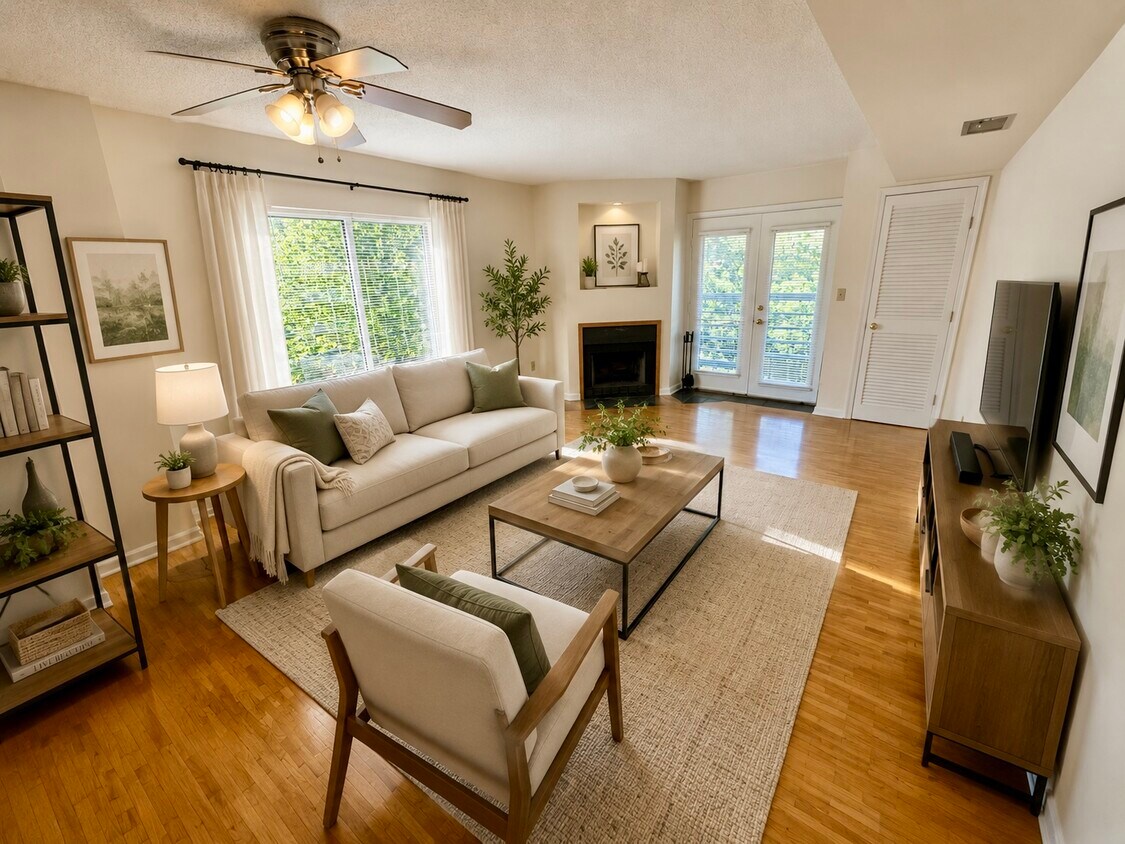
340 Franklin St Unit 8
Cambridge, MA 02139
Favorites
-
Bedrooms
2
-
Bathrooms
2
-
Square Feet
9,999 sq ft
-
Available
Available Jul 1
340 Franklin St Unit 8

Favorites
About This Home
12 Month Lease
,
Available Jul 1
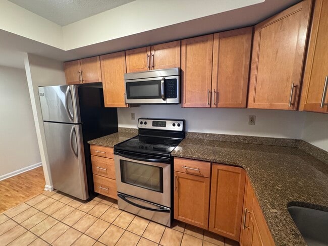
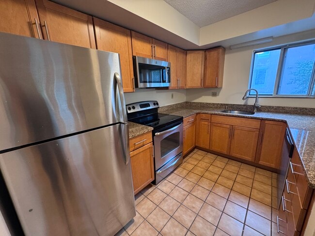
Address: 345 Franklin St, Cambridge No broker fee + No security deposit for qualified applicants | Available now or as late as 07/01/2026 | In Unit laundry | Great location in Central square few minutes to the T (Red line) This won't last long, Reach out today to schedule your showing! Transportation Bus: 47 Green St @ Magazine St (0.18 mi) Bus: 70 Western Ave @ Kinnaird St (0.10 mi) Bus: 64 Western Ave @ Kinnaird St (0.10 mi) Bus: 1 Massachusetts Ave opp Inman St (0.09 mi) Bus: 91 Western Ave @ Green St (0.13 mi) Bus: 83 Western Ave @ Green St (0.13 mi) Subway: Red Line Central (0.20 mi) Bus: 68 Broadway @ Lee St (0.36 mi) Bus: 69 Quincy St @ Harvard St (0.59 mi)
340 Franklin St is a condo located in Middlesex County and the 02139 ZIP Code. This area is served by the Cambridge School District attendance zone.
* Price shown is total price based on community-supplied monthly required fees. Excludes user-selected optional fees and variable or usage-based fees and required charges due at or prior to move-in or at move-out. Price, availability, fees, and any applicable rent special are subject to change without notice.
* Square footage definitions vary. Displayed square footage is approximate.
Contact
- Contact
Location
Get Directions
As one of the top-ranking neighborhoods to live in in the city of Cambridge, Riverside is a premier spot for waterfront views, outdoor recreation, and a happening nightlife scene. Large, colorful homes and historic buildings mark this neighborhood with local charm that you won’t want to miss. Exuding a college-town vibe, Riverside is situated directly south of Harvard University, so though the neighborhood feels family-friendly, it’s also very youthful due to the proximity to this prestigious university.
But Harvard isn’t the only school in walking distance of Riverside. Massachusetts Institute of Technology (known as MIT) is just two miles from Riverside, making this neighborhood an educational hub. Whether you want to walk, drive, or make use of public transit, by bus or subway, this area is very commuter-friendly.
Learn more about living in Riverside
Education
| Colleges & Universities | Distance | ||
|---|---|---|---|
| Colleges & Universities | Distance | ||
| Walk: | 5 min | 0.3 mi | |
| Walk: | 16 min | 0.8 mi | |
| Drive: | 3 min | 1.4 mi | |
| Drive: | 4 min | 1.8 mi |
340 Franklin St Unit 8 is within 5 minutes or 0.3 mile from Cambridge College. It is also near MIT and Harvard University.
Schools


Public Elementary & Middle School
Grades PK-8
421 Students
Attendance Zone
Public Elementary School
Grades PK-5
401 Students
Attendance Zone
Public Middle School
Grades 6-8
286 Students
Attendance Zone
Public Middle School
Grades 6-8
317 Students
Attendance Zone
Public High School
Grades 9-12
2,096 Students
Attendance Zone
Private Elementary School
Grades K-5
6 Students
Nearby
Private Elementary & Middle School
Grades PK-8
54 Students
Nearby
Private Middle & High School
Grades 6-12
29 Students
Nearby
School data provided by
 The GreatSchools Rating helps parents compare schools within a state based on a variety of school quality indicators and provides a helpful picture of how effectively each school serves all of its students. Ratings are on a scale of 1 (below average) to 10 (above average) and can include test scores, college readiness, academic progress, advanced courses, equity, discipline and attendance data. We also advise parents to visit schools, consider other information on school performance and programs, and consider family needs as part of the school selection process.
View GreatSchools Rating Methodology
Data provided by GreatSchools.org © 2026. All rights reserved.
View GreatSchools Rating Methodology
Data provided by GreatSchools.org © 2026. All rights reserved.
Transportation options available in Cambridge include Central Square Station, located 0.2 mile from 340 Franklin St Unit 8. 340 Franklin St Unit 8 is near General Edward Lawrence Logan International, located 8.4 miles or 15 minutes away.
| Transit / Subway | Distance | ||
|---|---|---|---|
| Transit / Subway | Distance | ||
|
|
Walk: | 4 min | 0.2 mi |
| Drive: | 4 min | 1.2 mi | |
|
|
Drive: | 3 min | 1.3 mi |
|
|
Drive: | 4 min | 1.9 mi |
|
|
Drive: | 5 min | 2.2 mi |
| Commuter Rail | Distance | ||
|---|---|---|---|
| Commuter Rail | Distance | ||
|
|
Drive: | 5 min | 2.4 mi |
|
|
Drive: | 4 min | 2.5 mi |
|
|
Drive: | 7 min | 3.4 mi |
|
|
Drive: | 10 min | 4.3 mi |
| Drive: | 12 min | 7.2 mi |
| Airports | Distance | ||
|---|---|---|---|
| Airports | Distance | ||
|
General Edward Lawrence Logan International
|
Drive: | 15 min | 8.4 mi |
Getting Around
 What do Walkability, Transit, Drivability, and Bikeability mean?
Walkability measures the walking distance to day-to-day needs.
Transit measures access to public transportation.
Drivability measures congestion, parking availability, and access to major roads.
Bikeability measures the suitability for cycling.
How It Works
What do Walkability, Transit, Drivability, and Bikeability mean?
Walkability measures the walking distance to day-to-day needs.
Transit measures access to public transportation.
Drivability measures congestion, parking availability, and access to major roads.
Bikeability measures the suitability for cycling.
How It Works
Exceptionally Walkable
Walkability
100
/ 100
Exceptional Public Transit
Transit
90
/ 100
Somewhat Drivable
Drivability
30
/ 100
Exceptionally Bikeable
Bikeability
90
/ 100
Scores provided by
-
Soundscore™
-
/ 100
Traffic
-Airport
-Businesses
-Scores provided by
HowLoud What is a Sound Score Rating? A Sound Score Rating aggregates noise caused by vehicle traffic, airplane traffic and local sources. How It WorksTime and distance from 340 Franklin St Unit 8.
| Shopping Centers | Distance | ||
|---|---|---|---|
| Shopping Centers | Distance | ||
| Walk: | 10 min | 0.5 mi | |
| Walk: | 11 min | 0.6 mi | |
| Walk: | 15 min | 0.8 mi |
340 Franklin St Unit 8 has 3 shopping centers within 0.8 mile, which is about a 15-minute walk. The miles and minutes will be for the farthest away property.
| Parks and Recreation | Distance | ||
|---|---|---|---|
| Parks and Recreation | Distance | ||
|
Harvard Museum of Natural History
|
Drive: | 4 min | 1.5 mi |
|
Mineralogical and Geological Museum
|
Drive: | 4 min | 1.5 mi |
|
Longfellow National Historic Site
|
Drive: | 4 min | 1.9 mi |
|
Charles River Reservation
|
Drive: | 6 min | 2.2 mi |
|
Coit Observatory
|
Drive: | 5 min | 2.3 mi |
340 Franklin St Unit 8 has 5 parks within 2.3 miles, including Harvard Museum of Natural History, Mineralogical and Geological Museum, and Longfellow National Historic Site.
| Hospitals | Distance | ||
|---|---|---|---|
| Hospitals | Distance | ||
| Walk: | 14 min | 0.8 mi | |
| Drive: | 4 min | 2.0 mi | |
| Drive: | 5 min | 2.2 mi |
340 Franklin St Unit 8 has 3 hospitals within 2.2 miles, the nearest is Cambridge Health Alliance which is 0.8 mile away and a 14 minute walk.
| Military Bases | Distance | ||
|---|---|---|---|
| Military Bases | Distance | ||
| Drive: | 25 min | 13.3 mi | |
| Drive: | 28 min | 16.4 mi | |
| Drive: | 36 min | 20.4 mi |
340 Franklin St Unit 8 has 3 military bases within 20.4 miles, the nearest is Hanscom Air Force Base which is 13.3 miles away and a 25 minute drive.
340 Franklin St Unit 8 Photos
What Are Walk Score®, Transit Score®, and Bike Score® Ratings?
Walk Score® measures the walkability of any address. Transit Score® measures access to public transit. Bike Score® measures the bikeability of any address.
What is a Sound Score Rating?
A Sound Score Rating aggregates noise caused by vehicle traffic, airplane traffic and local sources.
340 Franklin St
Cambridge, MA 02139