
$6,250
/ Month
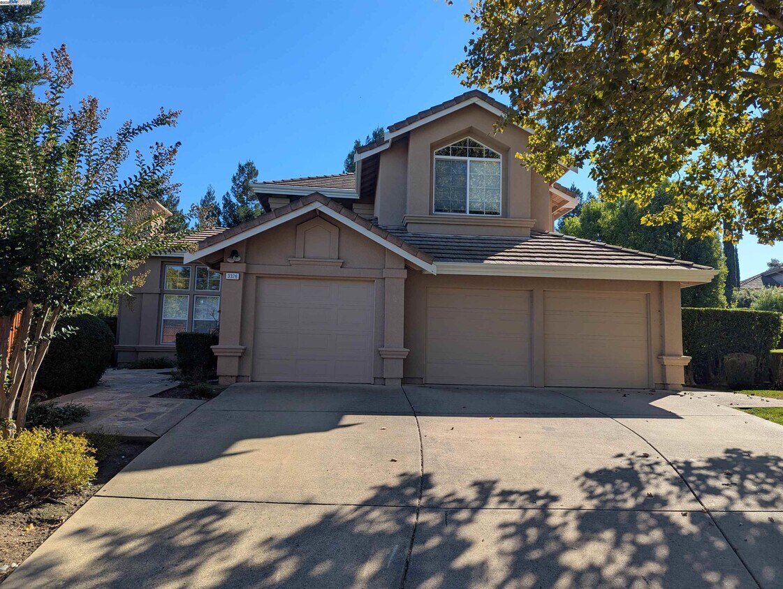
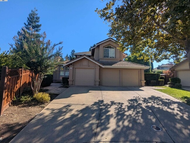
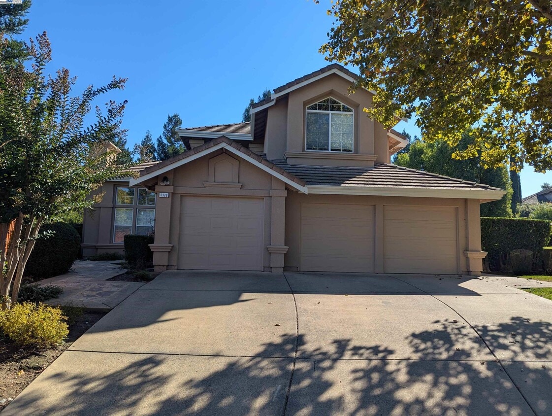
3326 Camillo Ct
Pleasanton, CA 94566
Today
|
Edit
Favorites
925-639-7847
-
Bedrooms
4
-
Bathrooms
3
-
Square Feet
2,680 sq ft
-
Available
Available Now
Highlights
- Gated Community
- Contemporary Architecture
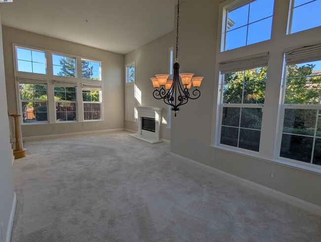
- Family Room with Fireplace
- 2 Fireplaces
- Community Pool
- Tennis Courts
3326 Camillo Ct

Favorites
About This Home
Available Now
Wow....An absolutely Perfect Lease/Rental in the Gated Community of Ruby Hill. With a Great Floor Plan,Large,Private Yard,3-Car Garage & Located in a Quiet,Peaceful Cul-de-sac Setting,your Gated Golf Course & Country Club Living is just a call away! Clean & Ready to go! Owner Pays HOA Dues & Gardener. Tenant Pays All Other Utilities.
3326 Camillo Ct is a house located in Alameda County and the 94566 ZIP Code. This area is served by the Livermore Valley Joint Unified attendance zone.
* Price shown is base rent. Excludes user-selected optional fees and variable or usage-based fees and required charges due at or prior to move-in or at move-out. Price, availability, fees, and any applicable rent special are subject to change without notice.
* Square footage definitions vary. Displayed square footage is approximate.
Home Details
Home Type
Single Family Detached Home
Year Built
Built in 1996
Bedrooms and Bathrooms
3 Full Bathrooms
4 Bedrooms
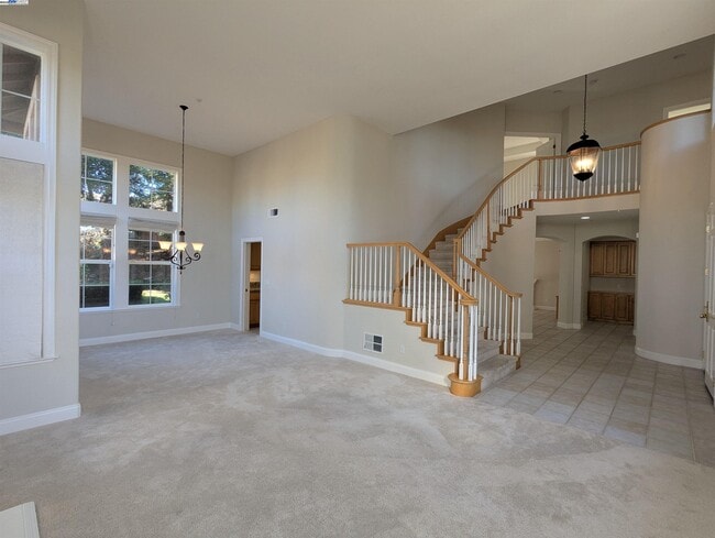
Flooring
Tile
Carpet
Home Design
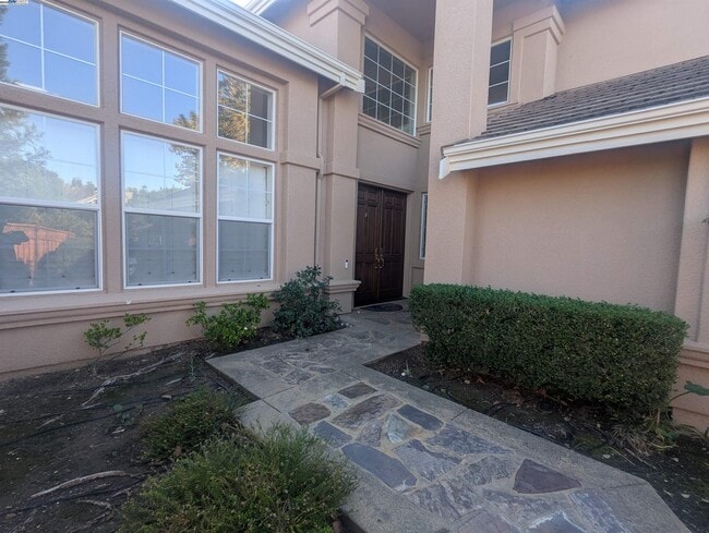
Contemporary Architecture
Tile Roof
Stucco
Slab Foundation
Interior Spaces
Family Room with Fireplace
2 Fireplaces
Living Room with Fireplace
2-Story Property
Kitchen
Breakfast Area or Nook
Laundry
Dryer
Washer
Listing and Financial Details
Assessor Parcel Number 9501533
Lot Details
0.27 Acre Lot
Parking
3 Car Attached Garage
Garage Door Opener
Utilities
Zoned Heating and Cooling System
Community Details
Amenities
Community Barbecue Grill
Picnic Area
Overview
Greenbelt
$295 Monthly HOA Fees
Ruby Hill HOA, Phone Number (925) 417-1903
Built by Signature
Ruby Hill Subdivision
Association fees include management fee, reserves, security/gate fee
Recreation
Community Pool
Tennis Courts
Park
Security
Gated Community
Contact
- Listed by Robert Gibbons | Foundation Real Estate
- Phone Number
- Contact
-
Source
 Bay East Association of REALTORS ®
Copyright© 2025 Bay East, Contra Costa, bridgeMLS. All rights reserved. All information provided by the listing agent/broker is deemed reliable but is not guaranteed and should be independently verified.
Location
Get Directions
The cities of Livermore, Dublin and Pleasanton form a loosely shaped triangle within California's Tri-Valley region, a cluster of three small valleys about 33 miles east of San Francisco and 35 miles northeast of San Jose. Known for its Mediterranean climate, rolling hills and historic vineyards, this once bucolic region now boasts three separate downtown areas, a bustling business community and some of the best wineries in the state.
At the eastern end of the region lies the city of Livermore. Once known as Livermores, Livermore Ranch and Nottingham, the city sits at the center of Livermore Valley, a historic region dotted with more than 5,000 acres of mostly family-owned vineyards. A pastoral neighborhood known for its charming yet functional hilltop windmills, Livermore hosts the internationally recognized and sometimes controversial center of scientific research, Lawrence Livermore National Laboratories.
Learn more about living in Dublin/Pleasanton/Livermore
Education
| Colleges & Universities | Distance | ||
|---|---|---|---|
| Colleges & Universities | Distance | ||
| Drive: | 13 min | 6.0 mi | |
| Drive: | 20 min | 12.3 mi | |
| Drive: | 24 min | 14.6 mi | |
| Drive: | 36 min | 23.9 mi |
3326 Camillo Ct is within 13 minutes or 6.0 miles from Las Positas College. It is also near Diablo Valley Coll, San Ramon and Ohlone College, Fremont Campus.
Schools


Public Elementary School
Grades K-5
652 Students
Attendance Zone
Public Elementary School
Grades K-5
478 Students
Nearby
Public Middle School
Grades 6-8
883 Students
Attendance Zone
Public High School
Grades 9-12
2,279 Students
Attendance Zone
Private Elementary School
Grades PK-3
Nearby
Private Elementary & Middle School
Grades K-8
271 Students
Nearby
Private Elementary, Middle & High School
Grades 1-12
Nearby
School data provided by
 The GreatSchools Rating helps parents compare schools within a state based on a variety of school quality indicators and provides a helpful picture of how effectively each school serves all of its students. Ratings are on a scale of 1 (below average) to 10 (above average) and can include test scores, college readiness, academic progress, advanced courses, equity, discipline and attendance data. We also advise parents to visit schools, consider other information on school performance and programs, and consider family needs as part of the school selection process.
View GreatSchools Rating Methodology
Data provided by GreatSchools.org © 2025. All rights reserved.
View GreatSchools Rating Methodology
Data provided by GreatSchools.org © 2025. All rights reserved.
Transportation options available in Pleasanton include Dublin Pleasanton Station, located 11.5 miles from 3326 Camillo Ct. 3326 Camillo Ct is near Norman Y Mineta San Jose International, located 27.2 miles or 37 minutes away, and Metro Oakland International, located 30.3 miles or 41 minutes away.
| Transit / Subway | Distance | ||
|---|---|---|---|
| Transit / Subway | Distance | ||
|
|
Drive: | 18 min | 11.5 mi |
|
|
Drive: | 18 min | 11.8 mi |
| Commuter Rail | Distance | ||
|---|---|---|---|
| Commuter Rail | Distance | ||
| Drive: | 11 min | 5.1 mi | |
| Drive: | 11 min | 5.2 mi | |
| Drive: | 15 min | 6.0 mi | |
| Drive: | 16 min | 6.0 mi | |
| Drive: | 17 min | 8.5 mi |
| Airports | Distance | ||
|---|---|---|---|
| Airports | Distance | ||
|
Norman Y Mineta San Jose International
|
Drive: | 37 min | 27.2 mi |
|
Metro Oakland International
|
Drive: | 41 min | 30.3 mi |
Time and distance from 3326 Camillo Ct.
| Shopping Centers | Distance | ||
|---|---|---|---|
| Shopping Centers | Distance | ||
| Drive: | 4 min | 1.4 mi | |
| Drive: | 8 min | 3.2 mi | |
| Drive: | 9 min | 4.0 mi |
3326 Camillo Ct has 3 shopping centers within 4.0 miles, which is about a 9-minute drive. The miles and minutes will be for the farthest away property.
| Parks and Recreation | Distance | ||
|---|---|---|---|
| Parks and Recreation | Distance | ||
|
Shadow Cliffs Regional Recreation Area
|
Drive: | 13 min | 5.6 mi |
|
Del Valle Regional Park
|
Drive: | 32 min | 12.2 mi |
|
Sunol Regional Wilderness
|
Drive: | 28 min | 12.5 mi |
|
Brushy Peak Regional Preserve
|
Drive: | 23 min | 12.5 mi |
|
Los Vaqueros Watershed
|
Drive: | 24 min | 14.0 mi |
3326 Camillo Ct has 5 parks within 14.0 miles, including Shadow Cliffs Regional Recreation Area, Del Valle Regional Park, and Sunol Regional Wilderness.
| Hospitals | Distance | ||
|---|---|---|---|
| Hospitals | Distance | ||
| Drive: | 15 min | 6.6 mi |
3326 Camillo Ct is 6.6 miles and a 15 minute drive from Stanford Health Care - ValleyCare.
| Military Bases | Distance | ||
|---|---|---|---|
| Military Bases | Distance | ||
| Drive: | 43 min | 30.0 mi |
3326 Camillo Ct is 30.0 miles and a 43 minute drive from Ames Research Center.
You May Also Like
Similar Rentals Nearby


What Are Walk Score®, Transit Score®, and Bike Score® Ratings?
Walk Score® measures the walkability of any address. Transit Score® measures access to public transit. Bike Score® measures the bikeability of any address.
What is a Sound Score Rating?
A Sound Score Rating aggregates noise caused by vehicle traffic, airplane traffic and local sources
3326 Camillo Ct
Pleasanton, CA 94566