

3325 Glendora Dr Unit 1
San Mateo, CA 94403
-
Bedrooms
3
-
Bathrooms
2
-
Square Feet
2,200 sq ft
-
Available
Available Now
Highlights
- Pets Allowed
- Hardwood Floors

About This Home
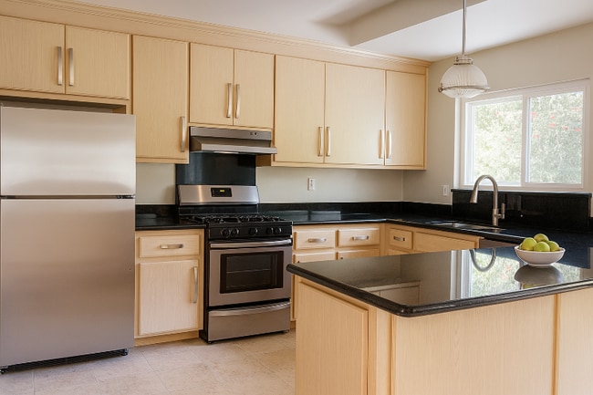
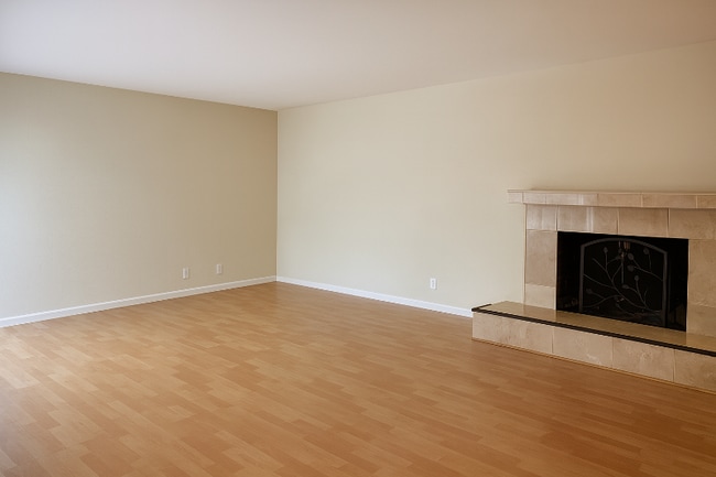
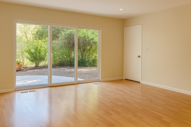
Property Id: 2152173 Charming remodeled apartment in San Mateo's Laurelwood / Westwood Knolls area, set along Glendora Dr. Spacious layout with an en-suite primary bedroom with his & her closets, large living room, and open dining area. 2 car garage. Shared washer & dryer. Stainless-steel kitchen with dishwasher and full range/oven. Secluded private backyard in quiet neighborhood. 5 minutes to Safeway, Mollie Stone's, CVS, Walgreens, Starbucks, Philz, Peet's Coffee, Chase and Citi Bank, Ace Hardware, and Downtown: Alana's Cafe, Sephora, Il Fornaio, Apple, and more. Located for Highlands Elementary (K 5), Abbott Middle (6 8), and Hillsdale High (9 12). Quick access to Hwy 92 & I-280 (and US-101 via 92) and nearby Caltrain at Hillsdale. Lease Duration: 1 Year Minimum. Security Deposit: 1 Month Deposit. Pet Policy: Pets allowed with deposit. No smoking. Tenant pays: All utilities.
3325 Glendora Dr is an apartment community located in San Mateo County and the 94403 ZIP Code.
Features
- Dishwasher
- Hardwood Floors
Fees and Policies
The fees below are based on community-supplied data and may exclude additional fees and utilities.
- Dogs Allowed
-
Fees not specified
- Cats Allowed
-
Fees not specified
- Parking
-
Garage--
Contact
- Phone Number
- Contact
-
Source

- Dishwasher
- Hardwood Floors
Located about halfway between San Francisco and San Jose, Sugarloaf is a peaceful, suburban neighborhood in San Mateo. Sugarloaf is predominantly residential, touting an array of single-family houses and apartment buildings atop scenic hillsides. However, Sugarloaf also provides plenty of shopping opportunities, from the extensive retail offerings of the Hillsdale Shopping Center to the unique finds in local shops along 37th Avenue.
Sugarloaf residents enjoy ample outdoor activities at the sprawling Laurelwood Park in addition to quick commutes for those working at the San Mateo Medical Center and the College of San Mateo. Convenience to El Camino Real, J. Arthur Younger Freeway, the Hillsdale CalTrain Station, and San Francisco International Airport makes getting around from Sugarloaf a breeze.
Learn more about living in Sugarloaf| Colleges & Universities | Distance | ||
|---|---|---|---|
| Colleges & Universities | Distance | ||
| Drive: | 3 min | 1.2 mi | |
| Drive: | 15 min | 9.9 mi | |
| Drive: | 20 min | 13.6 mi | |
| Drive: | 20 min | 14.0 mi |
Transportation options available in San Mateo include Millbrae (Caltrain Transfer Platform), located 7.6 miles from 3325 Glendora Dr Unit 1. 3325 Glendora Dr Unit 1 is near San Francisco International, located 11.3 miles or 16 minutes away, and Metro Oakland International, located 26.9 miles or 34 minutes away.
| Transit / Subway | Distance | ||
|---|---|---|---|
| Transit / Subway | Distance | ||
|
|
Drive: | 14 min | 7.6 mi |
|
|
Drive: | 14 min | 7.6 mi |
|
|
Drive: | 15 min | 10.9 mi |
| Drive: | 16 min | 11.0 mi | |
|
|
Drive: | 16 min | 11.2 mi |
| Commuter Rail | Distance | ||
|---|---|---|---|
| Commuter Rail | Distance | ||
| Drive: | 5 min | 1.9 mi | |
| Drive: | 5 min | 3.0 mi | |
| Drive: | 5 min | 3.0 mi | |
| Drive: | 7 min | 4.2 mi | |
| Drive: | 8 min | 5.9 mi |
| Airports | Distance | ||
|---|---|---|---|
| Airports | Distance | ||
|
San Francisco International
|
Drive: | 16 min | 11.3 mi |
|
Metro Oakland International
|
Drive: | 34 min | 26.9 mi |
Time and distance from 3325 Glendora Dr Unit 1.
| Shopping Centers | Distance | ||
|---|---|---|---|
| Shopping Centers | Distance | ||
| Walk: | 8 min | 0.4 mi | |
| Drive: | 3 min | 1.3 mi | |
| Drive: | 4 min | 2.2 mi |
| Parks and Recreation | Distance | ||
|---|---|---|---|
| Parks and Recreation | Distance | ||
|
San Mateo Arboretum
|
Drive: | 5 min | 3.2 mi |
|
Japanese Tea Garden (San Mateo)
|
Drive: | 6 min | 3.6 mi |
|
Crystal Springs Trail
|
Drive: | 7 min | 4.7 mi |
|
Shoreline Parks
|
Drive: | 9 min | 5.9 mi |
|
Pulgas Ridge Open Space Preserve
|
Drive: | 12 min | 7.6 mi |
| Hospitals | Distance | ||
|---|---|---|---|
| Hospitals | Distance | ||
| Drive: | 5 min | 2.1 mi | |
| Drive: | 12 min | 7.1 mi | |
| Drive: | 14 min | 9.4 mi |
| Military Bases | Distance | ||
|---|---|---|---|
| Military Bases | Distance | ||
| Drive: | 29 min | 21.1 mi |
You May Also Like
What Are Walk Score®, Transit Score®, and Bike Score® Ratings?
Walk Score® measures the walkability of any address. Transit Score® measures access to public transit. Bike Score® measures the bikeability of any address.
What is a Sound Score Rating?
A Sound Score Rating aggregates noise caused by vehicle traffic, airplane traffic and local sources

3325 Glendora Dr
San Mateo, CA 94403