

$4,990
/ Month
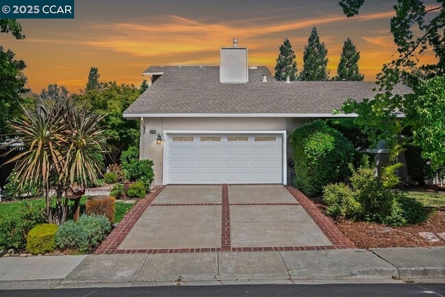
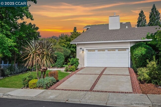
33 Leeds Ct E
Danville, CA 94526
Today
Favorites
510-406-4836
-
Bedrooms
4
-
Bathrooms
2.5
-
Square Feet
1,986 sq ft
-
Available
Available Now
Highlights
- View of Hills
- Clubhouse
- Contemporary Architecture
- Wood Flooring
- Solid Surface Countertops
- Community Pool
33 Leeds Ct E

Favorites
About This Home
Available Now
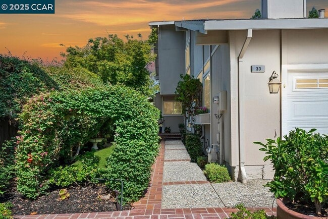
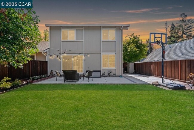
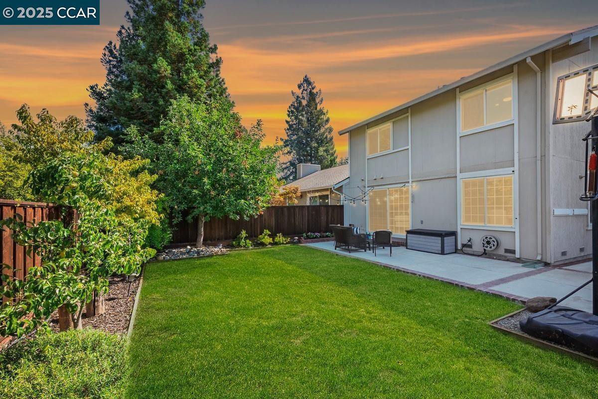
Coveted Sycamore neighborhood home on cul-de-sac w/in 2 miles of the charming Danville downtown. Updated 1986+/-SF on 2 levels. 4 bds. 2.5 bths. Formal living rm w/gas frpl,custom cabinetry. Open concept kitchen,dining & family rm. Inviting garden crtyrd entry w/seasonal blooms,mature shade tree,fountain,patio. Updated bckyrd design w/patio,lawn,multiple fruit trees,sprts ct. Hardwd & carpeted flrs. Crown molding. Hunter Douglas blinds/shutters. Ceiling fans. Smart switches. Skylights. Recessed lighting. Kitchen w/GE & KitchenAid appls,peninsula island/brkfast bar,beadboard detailed cabinets,built-in work station. Dining area w/new flush-mounted fixture adjacent to family rm. Slider to backyard. Primary suite w/west-facing views,sliding mirrored closet drs,shutters. 3 bdrms share large bthrm w/skylight,single-sink vanity,storage cabinet,tub/shwr combo. 2-car garage w/added recessed lights,ladder to overhead storage racks. Whole house fan. Central AC (2023),garden shed,timed drip irrigation,laundry niche. Updated ductwork,furnace,sealed crawl space & fencing. Near 10 acres of parks,3 clubhouses,3 pools,volleyball/pickleball cts,playgrnds,walking trails. Near Iron Horse Trail,weekly farmers market,top-rated K-8 SRVUSD schls w/in a mile. SRVHS w/in 2 mi.
33 Leeds Ct E is a house located in Contra Costa County and the 94526 ZIP Code. This area is served by the San Ramon Valley Unified attendance zone.
* Price shown is base rent. Excludes user-selected optional fees and variable or usage-based fees and required charges due at or prior to move-in or at move-out. Price, availability, fees, and any applicable rent special are subject to change without notice.
* Square footage definitions vary. Displayed square footage is approximate.
Home Details
Year Built
Built in 1975
Bedrooms and Bathrooms
2.5 Bathrooms
4 Bedrooms
Flooring
Wood
Tile
Carpet
Home Design
Contemporary Architecture
Wood Siding
Twin Home
Composition Shingle Roof
Interior Spaces
Living Room with Fireplace
Double Pane Windows
Window Screens
Raised Hearth
Gas Fireplace
2-Story Property
Kitchen
Solid Surface Countertops
Built-In Range
Breakfast Bar
Microwave
Dishwasher
Self-Cleaning Oven
Plumbed For Ice Maker
Laundry
Laundry closet
Dryer
Washer
220 Volts In Laundry
Listing and Financial Details
Assessor Parcel Number 2073500189
Lot Details
4,370 Sq Ft Lot
Garden
Back and Front Yard
Parking
2 Car Attached Garage
Side by Side Parking
Front Facing Garage
Garage Door Opener
Utilities
Whole House Fan
Forced Air Heating and Cooling System
Gas Water Heater
220 Volts in Kitchen
Views
Views of Hills
Community Details
Amenities
Clubhouse
Community Barbecue Grill
Picnic Area
Overview
Greenbelt
$145 Monthly HOA Fees
Sycamore Homes Assoc Association, Phone Number (925) 837-9669
Sycamore Homes Subdivision
Association fees include common area maintenance, management fee, reserves
Recreation
Community Pool
Tennis Courts
Park
Contact
- Listed by Joujou Chawla | Compass
- Phone Number
- Contact
-
Source
 Contra Costa Association of REALTORS®
Copyright © 2025 Bay East, CCAR, bridgeMLS. Based on information from Bay East and Contra Costa Association of REALTORS® and bridgeMLS. All data, including all measurements and calculations of area, is obtained from various sources and has not been, and will not be, verified by broker or MLS. All information should be independently reviewed and verified for accuracy. If a floor plan is included, the floor plan is for illustrative purposes only, and the actual dimensions and layout of the home may differ from the floor plan. Buyer is urged to make a detailed inspection of the property, and if any aspect of a floor plan is critical to the buyer's decision to purchase, buyer must conduct their own measurements and inspection. Properties may or may not be listed by the office/agent presenting the information.
Location
Get Directions
Danville is an upscale suburban community located just south of Walnut Creek and about twenty miles east of Oakland. Residents enjoy an ideal location, surrounded by scenic rolling hills and lush greenery while still being within minutes of the Bay Area’s biggest cities. The thriving Downtown district along Hartz Boulevard is packed with terrific restaurants, specialty shops, and bars, as well as unique attractions like the Village Theatre and Art Gallery and the Danville Farmers’ Market. The surrounding landscape offers terrific opportunities to make the most of California’s natural beauty, with Las Trampas Regional Wilderness and the Diablo Foothills just outside of town providing great venues for hiking and camping.
Learn more about living in Danville
Education
| Colleges & Universities | Distance | ||
|---|---|---|---|
| Colleges & Universities | Distance | ||
| Drive: | 14 min | 7.5 mi | |
| Drive: | 25 min | 14.4 mi | |
| Drive: | 26 min | 18.1 mi | |
| Drive: | 37 min | 25.9 mi |
33 Leeds Ct E is within 14 minutes or 7.5 miles from Diablo Valley Coll, San Ramon. It is also near Saint Marys Coll. of Calif. and Las Positas College.
Schools


Public Elementary School
Grades K-5
497 Students
Nearby
Public Elementary School
Grades K-5
437 Students
Attendance Zone
Public Middle School
Grades 6-8
878 Students
Attendance Zone
Public High School
Grades 9-12
1,981 Students
Attendance Zone
Private Elementary & Middle School
Grades PK-8
Nearby
Private Elementary & Middle School
Grades K-8
355 Students
Nearby
Private Elementary School
Grades K-3
12 Students
Nearby
Private Middle & High School
Grades 6-12
536 Students
Nearby
School data provided by
 The GreatSchools Rating helps parents compare schools within a state based on a variety of school quality indicators and provides a helpful picture of how effectively each school serves all of its students. Ratings are on a scale of 1 (below average) to 10 (above average) and can include test scores, college readiness, academic progress, advanced courses, equity, discipline and attendance data. We also advise parents to visit schools, consider other information on school performance and programs, and consider family needs as part of the school selection process.
View GreatSchools Rating Methodology
Data provided by GreatSchools.org © 2025. All rights reserved.
View GreatSchools Rating Methodology
Data provided by GreatSchools.org © 2025. All rights reserved.
Transportation options available in Danville include Walnut Creek Station, located 9.8 miles from 33 Leeds Ct E. 33 Leeds Ct E is near Metro Oakland International, located 28.7 miles or 37 minutes away, and San Francisco International, located 37.9 miles or 56 minutes away.
| Transit / Subway | Distance | ||
|---|---|---|---|
| Transit / Subway | Distance | ||
|
|
Drive: | 14 min | 9.8 mi |
|
|
Drive: | 13 min | 10.3 mi |
|
|
Drive: | 15 min | 11.3 mi |
|
|
Drive: | 15 min | 11.5 mi |
|
|
Drive: | 16 min | 12.0 mi |
| Commuter Rail | Distance | ||
|---|---|---|---|
| Commuter Rail | Distance | ||
| Drive: | 20 min | 14.7 mi | |
| Drive: | 20 min | 14.8 mi | |
|
|
Drive: | 29 min | 15.8 mi |
| Drive: | 29 min | 15.8 mi | |
| Drive: | 27 min | 19.5 mi |
| Airports | Distance | ||
|---|---|---|---|
| Airports | Distance | ||
|
Metro Oakland International
|
Drive: | 37 min | 28.7 mi |
|
San Francisco International
|
Drive: | 56 min | 37.9 mi |
Time and distance from 33 Leeds Ct E.
| Shopping Centers | Distance | ||
|---|---|---|---|
| Shopping Centers | Distance | ||
| Drive: | 3 min | 1.5 mi | |
| Drive: | 4 min | 1.8 mi | |
| Drive: | 4 min | 1.9 mi |
33 Leeds Ct E has 3 shopping centers within 1.9 miles, which is about a 4-minute drive. The miles and minutes will be for the farthest away property.
| Parks and Recreation | Distance | ||
|---|---|---|---|
| Parks and Recreation | Distance | ||
|
Eugene O'Neill National Historic Site
|
Drive: | 11 min | 4.4 mi |
|
Bishop Ranch Regional Preserve
|
Drive: | 10 min | 6.5 mi |
|
Little Hills Picnic Ranch (By Reservation)
|
Drive: | 23 min | 9.2 mi |
|
Las Trampas Regional Wilderness
|
Drive: | 25 min | 9.6 mi |
|
Mount Diablo State Park
|
Drive: | 36 min | 11.4 mi |
33 Leeds Ct E has 5 parks within 11.4 miles, including Eugene O'Neill National Historic Site, Las Trampas Regional Wilderness, and Little Hills Picnic Ranch (By Reservation).
| Hospitals | Distance | ||
|---|---|---|---|
| Hospitals | Distance | ||
| Drive: | 9 min | 5.4 mi | |
| Drive: | 11 min | 8.3 mi | |
| Drive: | 15 min | 11.2 mi |
33 Leeds Ct E has 3 hospitals within 11.2 miles, the nearest is San Ramon Regional Medical Center which is 5.4 miles away and a 9 minute drive.
You May Also Like
Similar Rentals Nearby


What Are Walk Score®, Transit Score®, and Bike Score® Ratings?
Walk Score® measures the walkability of any address. Transit Score® measures access to public transit. Bike Score® measures the bikeability of any address.
What is a Sound Score Rating?
A Sound Score Rating aggregates noise caused by vehicle traffic, airplane traffic and local sources
33 Leeds Ct E
Danville, CA 94526