
$4,800 / Month
33 Farragut Ave Unit 2
Somerville, MA 02144
1 Day Ago
Favorites
857-880-4916
-
Bedrooms
4
-
Bathrooms
2
-
Square Feet
1,850 sq ft
-
Available
Available Sep 1
Highlights
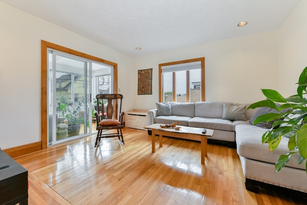
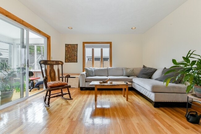
- Deck
- Property is near public transit
- Jogging Path
- No Cooling
- Park
- Shops
33 Farragut Ave Unit 2

Favorites
About This Home
$4,800 deposit,
Available Sep 1
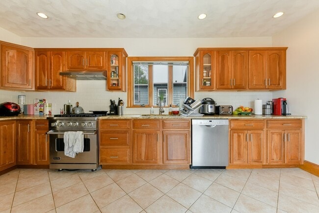
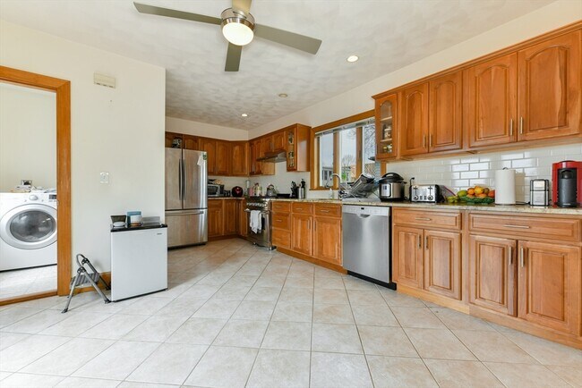
Available 9/1 - Renovated 4BD/2BA Duplex Near Teele & Davis Sq! This spacious two-level home features a modern eat-in kitchen with granite counters,stainless steel appliances,ample cabinetry,recessed lighting,and a private deck,with sunset views. Open-concept dining/living area flows into a sunny front room,perfect for a home office or den. Two bedrooms on each level offer privacy and flexibility. Hardwood floors,high ceilings,original wood trim,large primary bedroom,and in-unit laundry.With a walk score of 83,restaurants,cafes,parks and shopping are just moments away. There are multiple bus routes (87 & 88) at the end of the street for easy access to the Redline T and there's easy access to Route 2,16 and 93 as well. One off street parking is negotiable if needed. Floor plan available upon request. MLS# 73387720
33 Farragut Ave is a condo located in Middlesex County and the 02144 ZIP Code.
* Price shown is base rent and may not include non-optional fees and utilities.
Price, availability, fees, and any applicable rent special are subject to change without notice.
* Square footage definitions vary. Displayed square footage is approximate.
Home Details
Home Type
Condominium
Year Built
Built in 1880
Accessible Home Design
Entry on the 2nd floor
Bedrooms and Bathrooms
2 Full Bathrooms
4 Bedrooms
Interior Spaces
1,850 Sq Ft Home
Kitchen
Range
Freezer
Dishwasher
Disposal
Laundry
Dryer
Laundry in unit
Washer
Listing and Financial Details
Security Deposit $4,800
Property Available on 9/1/25
12 Month Lease Term
Assessor Parcel Number 747518
Rent includes water, sewer
Location
Property is near public transit
Property is near schools
Lot Details
4,791 Sq Ft Lot
Outdoor Features
Deck
Utilities
No Cooling
Heating System Uses Natural Gas
Community Details
Amenities
Shops
Coin Laundry
Overview
No Home Owners Association
Pet Policy
No Pets Allowed
Recreation
Jogging Path
Park
Bike Trail
Fees and Policies
The fees below are based on community-supplied data and may exclude additional fees and utilities.
Contact
- Listed by Christopher Brooks | Compass
- Phone Number
-
Source
 MLS Property Information Network
The property listing data and information set forth herein were provided to MLS Property Information Network, Inc. from third party sources, including sellers, lessors and public records, and were compiled by MLS Property Information Network, Inc. The property listing data and information are for the personal, non-commercial use of consumers having a good faith interest in purchasing or leasing listed properties of the type displayed to them and may not be used for any purpose other than to identify prospective properties which such consumers may have a good faith interest in purchasing or leasing. MLS Property Information Network, Inc. and its subscribers disclaim any and all representations and warranties as to the accuracy of the property listing data and information set forth herein. All properties are subject to prior sale, change or withdrawal. Copyright © 2025 MLS Property Information Network, Inc. All rights reserved.
Location
Get Directions
Amenities
- Dishwasher
- Disposal
- Range
- Refrigerator
- Freezer
- Deck
Attractive homes and tree-shaded sidewalks line the streets of West Somerville, a mainly-residential suburban community along Alewife Brook Parkway. The east side of the neighborhood borders the Tufts University campus, making it an excellent location for students, faculty, and staff to find apartments. Large chain grocery stores and corner markets in the community give residents numerous convenient options for grabbing their everyday necessities.
While the close proximity to the university does attract renters from the collegiate demographic, there is plenty for families to appreciate as well: multiple public schools can be found within and around the neighborhood, and the Dilboy sports facilities on the west side are perfect venues for all-ages fun.
Learn more about living in West Somerville
Education
| Colleges & Universities | Distance | ||
|---|---|---|---|
| Colleges & Universities | Distance | ||
| Drive: | 4 min | 1.1 mi | |
| Drive: | 5 min | 1.9 mi | |
| Drive: | 5 min | 2.3 mi | |
| Drive: | 7 min | 3.0 mi |
33 Farragut Ave Unit 2 is within 4 minutes or 1.1 miles from Tufts Univ., Medford. It is also near Lesley University, Porter and Lesley University.
Transportation options available in Somerville include Alewife, located 1.0 mile from 33 Farragut Ave Unit 2. 33 Farragut Ave Unit 2 is near General Edward Lawrence Logan International, located 8.8 miles or 17 minutes away.
| Transit / Subway | Distance | ||
|---|---|---|---|
| Transit / Subway | Distance | ||
| Walk: | 19 min | 1.0 mi | |
| Drive: | 4 min | 1.3 mi | |
| Drive: | 4 min | 1.4 mi | |
|
|
Drive: | 3 min | 1.4 mi |
| Drive: | 4 min | 1.7 mi |
| Commuter Rail | Distance | ||
|---|---|---|---|
| Commuter Rail | Distance | ||
| Drive: | 4 min | 1.7 mi | |
|
|
Drive: | 5 min | 2.3 mi |
| Drive: | 6 min | 3.3 mi | |
| Drive: | 8 min | 3.8 mi | |
| Drive: | 8 min | 4.2 mi |
| Airports | Distance | ||
|---|---|---|---|
| Airports | Distance | ||
|
General Edward Lawrence Logan International
|
Drive: | 17 min | 8.8 mi |
Time and distance from 33 Farragut Ave Unit 2.
| Shopping Centers | Distance | ||
|---|---|---|---|
| Shopping Centers | Distance | ||
| Drive: | 4 min | 1.5 mi | |
| Drive: | 3 min | 1.6 mi | |
| Drive: | 4 min | 1.9 mi |
33 Farragut Ave Unit 2 has 3 shopping centers within 1.9 miles, which is about a 4-minute drive. The miles and minutes will be for the farthest away property.
| Parks and Recreation | Distance | ||
|---|---|---|---|
| Parks and Recreation | Distance | ||
|
Mineralogical and Geological Museum
|
Drive: | 6 min | 2.6 mi |
|
Harvard Museum of Natural History
|
Drive: | 6 min | 2.6 mi |
|
Harvard-Smithsonian Center for Astrophysics
|
Drive: | 6 min | 2.7 mi |
|
Mystic River Reservation
|
Drive: | 6 min | 2.7 mi |
|
Longfellow National Historic Site
|
Drive: | 6 min | 3.0 mi |
33 Farragut Ave Unit 2 has 5 parks within 3.0 miles, including Harvard-Smithsonian Center for Astrophysics, Harvard Museum of Natural History, and Mineralogical and Geological Museum.
| Hospitals | Distance | ||
|---|---|---|---|
| Hospitals | Distance | ||
| Drive: | 6 min | 3.1 mi | |
| Drive: | 8 min | 3.5 mi | |
| Drive: | 8 min | 4.6 mi |
33 Farragut Ave Unit 2 has 3 hospitals within 4.6 miles, the nearest is Mount Auburn Hospital which is 3.1 miles away and a 6 minute drive.
| Military Bases | Distance | ||
|---|---|---|---|
| Military Bases | Distance | ||
| Drive: | 19 min | 10.0 mi | |
| Drive: | 31 min | 17.5 mi |
33 Farragut Ave Unit 2 is 10.0 miles from Hanscom Air Force Base, and is convenient to other military bases, including US Military Reservation.
You May Also Like
Similar Rentals Nearby


What Are Walk Score®, Transit Score®, and Bike Score® Ratings?
Walk Score® measures the walkability of any address. Transit Score® measures access to public transit. Bike Score® measures the bikeability of any address.
What is a Sound Score Rating?
A Sound Score Rating aggregates noise caused by vehicle traffic, airplane traffic and local sources

33 Farragut Ave
Somerville, MA 02144