
$1,950
/ Month
324 Stevenson Rd
Erlanger, KY 41018
2 Weeks Ago
Favorites
324 Stevenson Rd

Favorites
Check Back Soon for Upcoming Availability
| Beds | Baths | Average SF |
|---|---|---|
| 4 Bedrooms 4 Bedrooms 4 Br | 2 Baths 2 Baths 2 Ba | — |
Fees and Policies
The fees below are based on community-supplied data and may exclude additional fees and utilities.
- Dogs Allowed
-
Fees not specified
- Cats Allowed
-
Fees not specified
About This Property
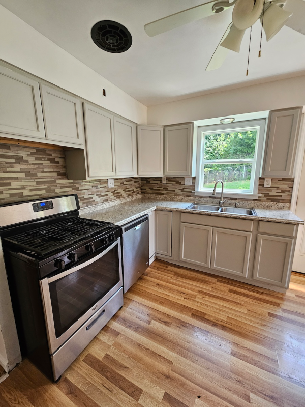
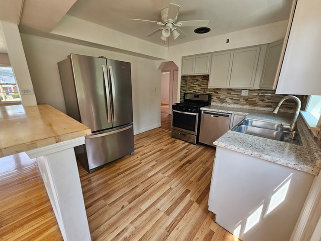
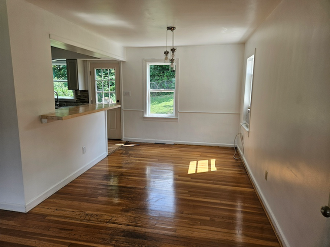
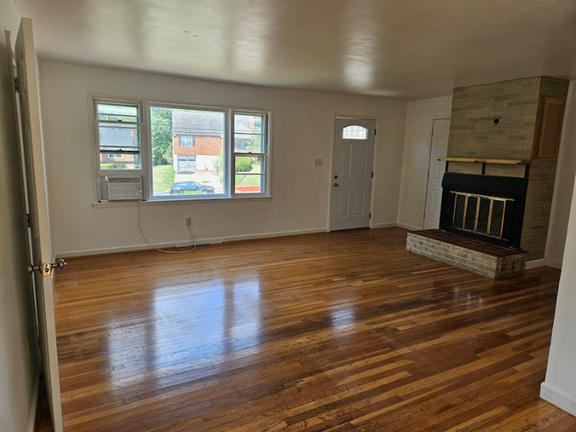
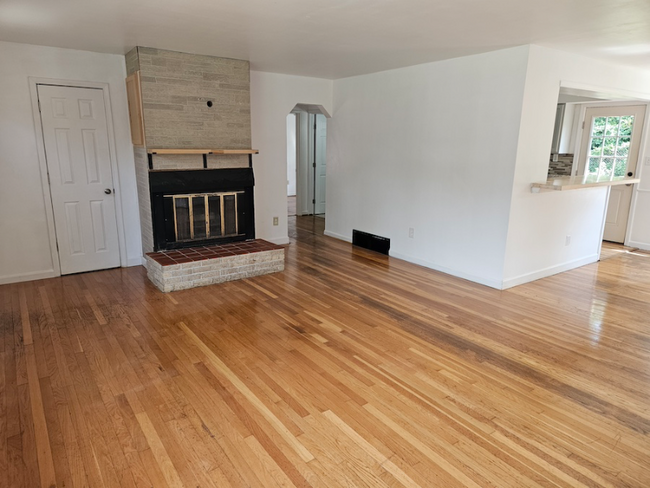
Property Id: 1534625 This house is conveniently located on Stevenson road between Turkeyfoot and Dixie Highway. Walk into the living room with an open concept dining and kitchen area. Off to the left is a bathroom and three bedrooms. Off to the right is a study, bathroom, and a huge bedroom. This area could act as a primary suite or as a mother-in-law unit. There is a large basement for storage and laundry. The backyard is fully fenced in! There is also a park just one block away. This is perfect for a family! Rent: $1950 Deposit: $2100 Call: Original Listing Page on Turbo Tenant: A one year lease is preferred. Utilities are not included. Pets are accepted. There are extra fees and deposits associated with pets. All applications are processed through Turbo Tenant. Our minimum acceptance requirements are a monthly household income of 3 times the rent, no evictions, and a credit score of 600+.
324 Stevenson Rd is a house located in Kenton County and the 41018 ZIP Code. This area is served by the Erlanger-Elsmere Independent attendance zone.
House Features
Dishwasher
Hardwood Floors
Microwave
Refrigerator
- Fireplace
- Dishwasher
- Microwave
- Oven
- Refrigerator
- Freezer
- Hardwood Floors
- Fenced Lot
- Lawn
Location
Get Directions
Northern Kentucky is a sprawling region located just south of Cincinnati, Ohio. The Ohio River hugs the northern, eastern, and western portions of the region, serving as a scenic destination for all kinds of outdoor recreation throughout the year. Florence, Dayton, Newport, Covington, Burlington, and Highland Heights are among the many communities included in the Northern Kentucky region.
Each community in Northern Kentucky offers its own unique identity and sense of character. The rentals in the area are just as diverse as Northern Kentucky itself, ranging from luxury apartments to charming houses and everything in between. Getting around the region is a breeze with convenience to Interstates 71, 75, 275, and 471.
Learn more about living in Northern KentuckyBelow are rent ranges for similar nearby apartments
Amenities
- Fireplace
- Dishwasher
- Microwave
- Oven
- Refrigerator
- Freezer
- Hardwood Floors
- Fenced Lot
- Lawn
Education
| Colleges & Universities | Distance | ||
|---|---|---|---|
| Colleges & Universities | Distance | ||
| Drive: | 5 min | 2.7 mi | |
| Drive: | 15 min | 9.7 mi | |
| Drive: | 21 min | 14.0 mi | |
| Drive: | 29 min | 17.1 mi |
324 Stevenson Rd is within 5 minutes or 2.7 miles from Thomas More College. It is also near College of Mount St. Joseph and Northern Kentucky University.
Schools


Public Elementary School
Grades PK-5
270 Students
Attendance Zone
Public Middle School
Grades 6-8
539 Students
Attendance Zone
Public High School
Grades 9-12
697 Students
Attendance Zone
Private Elementary & Middle School
Grades PK-8
399 Students
Nearby
Private Elementary School
Grades PK-6
22 Students
Nearby
School data provided by
 The GreatSchools Rating helps parents compare schools within a state based on a variety of school quality indicators and provides a helpful picture of how effectively each school serves all of its students. Ratings are on a scale of 1 (below average) to 10 (above average) and can include test scores, college readiness, academic progress, advanced courses, equity, discipline and attendance data. We also advise parents to visit schools, consider other information on school performance and programs, and consider family needs as part of the school selection process.
View GreatSchools Rating Methodology
Data provided by GreatSchools.org © 2025. All rights reserved.
View GreatSchools Rating Methodology
Data provided by GreatSchools.org © 2025. All rights reserved.
Transportation options available in Erlanger include The Banks Station, 2Nd & Main, located 9.9 miles from 324 Stevenson Rd. 324 Stevenson Rd is near Cincinnati/Northern Kentucky International, located 6.2 miles or 16 minutes away.
| Transit / Subway | Distance | ||
|---|---|---|---|
| Transit / Subway | Distance | ||
| Drive: | 15 min | 9.9 mi | |
| Drive: | 16 min | 10.0 mi | |
| Drive: | 16 min | 10.1 mi | |
| Drive: | 16 min | 10.2 mi | |
| Drive: | 16 min | 10.3 mi |
| Commuter Rail | Distance | ||
|---|---|---|---|
| Commuter Rail | Distance | ||
|
|
Drive: | 18 min | 11.0 mi |
| Airports | Distance | ||
|---|---|---|---|
| Airports | Distance | ||
|
Cincinnati/Northern Kentucky International
|
Drive: | 16 min | 6.2 mi |
Time and distance from 324 Stevenson Rd.
| Shopping Centers | Distance | ||
|---|---|---|---|
| Shopping Centers | Distance | ||
| Walk: | 7 min | 0.4 mi | |
| Walk: | 13 min | 0.7 mi | |
| Walk: | 16 min | 0.8 mi |
324 Stevenson Rd has 3 shopping centers within 0.8 mile, which is about a 16-minute walk. The miles and minutes will be for the farthest away property.
| Parks and Recreation | Distance | ||
|---|---|---|---|
| Parks and Recreation | Distance | ||
|
John G. & Phyllis W. Smale Riverfront Park
|
Drive: | 15 min | 10.0 mi |
|
Cincinnati History Museum
|
Drive: | 18 min | 11.0 mi |
|
Wilson Commons
|
Drive: | 19 min | 12.1 mi |
|
Imago Earth Center
|
Drive: | 21 min | 13.3 mi |
|
Embshoff Woods
|
Drive: | 25 min | 14.9 mi |
324 Stevenson Rd has 5 parks within 14.9 miles, including John G. & Phyllis W. Smale Riverfront Park, Embshoff Woods, and Cincinnati History Museum.
| Hospitals | Distance | ||
|---|---|---|---|
| Hospitals | Distance | ||
| Drive: | 4 min | 2.7 mi | |
| Drive: | 7 min | 3.5 mi | |
| Drive: | 7 min | 3.7 mi |
324 Stevenson Rd has 3 hospitals within 3.7 miles, the nearest is St. Elizabeth Florence which is 2.7 miles away and a 4 minute drive.
| Military Bases | Distance | ||
|---|---|---|---|
| Military Bases | Distance | ||
| Drive: | 84 min | 64.5 mi | |
| Drive: | 90 min | 69.5 mi | |
| Drive: | 92 min | 72.8 mi |
324 Stevenson Rd has 3 military bases within 72.8 miles, the nearest is Gentile Air Force Station which is 64.5 miles away and a 84 minute drive.
You May Also Like
Similar Rentals Nearby


What Are Walk Score®, Transit Score®, and Bike Score® Ratings?
Walk Score® measures the walkability of any address. Transit Score® measures access to public transit. Bike Score® measures the bikeability of any address.
What is a Sound Score Rating?
A Sound Score Rating aggregates noise caused by vehicle traffic, airplane traffic and local sources

324 Stevenson Rd
Erlanger, KY 41018