

$1,980 / Month
3239 Clearview Dr SW
Marietta, GA 30060
2 Weeks Ago
Favorites
3239 Clearview Dr SW

Favorites
Check Back Soon for Upcoming Availability
| Beds | Baths | Average SF |
|---|---|---|
| 3 Bedrooms 3 Bedrooms 3 Br | 3 Baths 3 Baths 3 Ba | 1,607 SF |
Fees and Policies
The fees below are based on community-supplied data and may exclude additional fees and utilities.
- Dogs Allowed
-
Fees not specified
- Cats Allowed
-
Fees not specified
About This Property
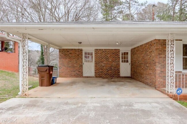
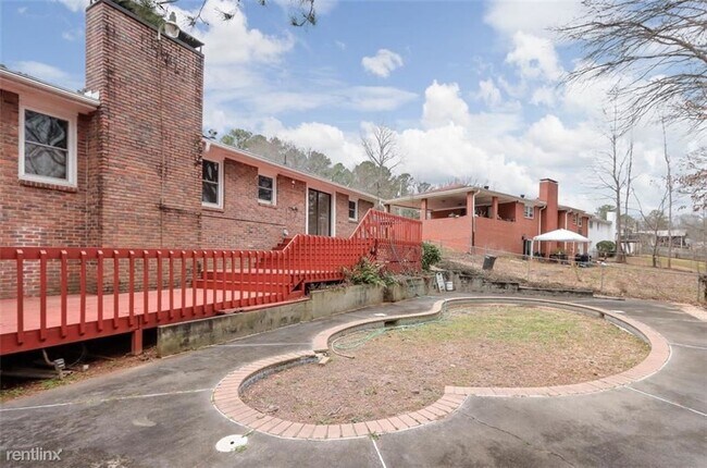
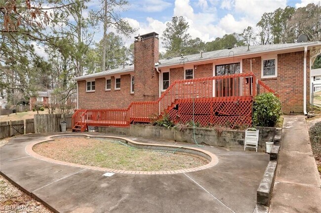
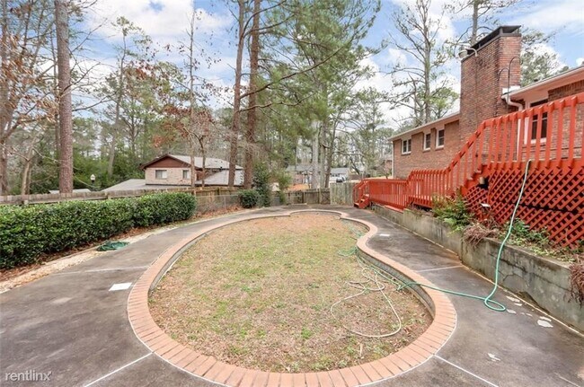
(844) 326-7613 - Charming All Brick Ranch perfect for your starter home! This home boasts 3 bedrooms, 3 baths, fully fenced in backyard, Open Floorplan, and deck off of breakfast area! Big, spacious front yard for the kids to run and play. Why are you still reading this ?? Hurry Over Before It's Sold ! (RLNE6518349) Pet policies: Small Dogs Allowed, Cats Allowed, Other, Large Dogs Allowed.
3239 Clearview Dr SW is a house located in Cobb County and the 30060 ZIP Code. This area is served by the Cobb County attendance zone.
Unique Features
- Pets -
Location
Get Directions
Moving to Marietta? Don’t let your feathers get ruffled the first time you’re told to turn at the big chicken. It’s not a joke. The 56-foot-tall landmark is a staple of most directions. A Georgia Tech student who obviously had a sense of humor designed the giant, steel bird in 1963. The beak opens and closes as the eyes spin around. Stop in for lunch! The chicken is perched atop a KFC. You can also grab (pluck?) a “Big Chicken” mug or T-shirt from the gift shop.
Marietta Square is the central hub for a city that dates back to 1834. The historic square contains antique stores, boutiques, gift shops, and restaurants. It’s also the location of the Marietta Farmer’s Market, a year-round market with more than 65 vendors.
Marietta contains a variety of important places, including Dobbins Air Force Base, Kennesaw State University-Marietta Campus, the Marietta Museum of History, and Six Flags White Water.
Learn more about living in MariettaBelow are rent ranges for similar nearby apartments
Amenities
- Pets -
Education
| Colleges & Universities | Distance | ||
|---|---|---|---|
| Colleges & Universities | Distance | ||
| Drive: | 10 min | 4.2 mi | |
| Drive: | 14 min | 6.6 mi | |
| Drive: | 14 min | 7.4 mi | |
| Drive: | 26 min | 13.7 mi |
3239 Clearview Dr SW is within 10 minutes or 4.2 miles from Chatt. Tech, Marietta. It is also near Chatt. Tech, Austell and Life University.
Schools


Public Elementary School
Grades PK-5
604 Students
Attendance Zone
Public Middle School
Grades 6-8
845 Students
Attendance Zone
Public High School
Grades 9-12
2,772 Students
Attendance Zone
Private Elementary, Middle & High School
Grades PK-12
34 Students
Nearby
Private Elementary & Middle School
Grades PK-8
98 Students
Nearby
Private Elementary School
Grades PK-2
100 Students
Nearby
School data provided by
 The GreatSchools Rating helps parents compare schools within a state based on a variety of school quality indicators and provides a helpful picture of how effectively each school serves all of its students. Ratings are on a scale of 1 (below average) to 10 (above average) and can include test scores, college readiness, academic progress, advanced courses, equity, discipline and attendance data. We also advise parents to visit schools, consider other information on school performance and programs, and consider family needs as part of the school selection process.
View GreatSchools Rating Methodology
Data provided by GreatSchools.org © 2025. All rights reserved.
View GreatSchools Rating Methodology
Data provided by GreatSchools.org © 2025. All rights reserved.
Transportation options available in Marietta include Hamilton E Holmes Station, located 13.2 miles from 3239 Clearview Dr SW. 3239 Clearview Dr SW is near Hartsfield - Jackson Atlanta International, located 25.9 miles or 40 minutes away.
| Transit / Subway | Distance | ||
|---|---|---|---|
| Transit / Subway | Distance | ||
|
|
Drive: | 22 min | 13.2 mi |
| Commuter Rail | Distance | ||
|---|---|---|---|
| Commuter Rail | Distance | ||
|
|
Drive: | 26 min | 15.3 mi |
| Airports | Distance | ||
|---|---|---|---|
| Airports | Distance | ||
|
Hartsfield - Jackson Atlanta International
|
Drive: | 40 min | 25.9 mi |
Time and distance from 3239 Clearview Dr SW.
| Shopping Centers | Distance | ||
|---|---|---|---|
| Shopping Centers | Distance | ||
| Drive: | 4 min | 1.7 mi | |
| Drive: | 4 min | 1.9 mi | |
| Drive: | 5 min | 2.1 mi |
3239 Clearview Dr SW has 3 shopping centers within 2.1 miles, which is about a 5-minute drive. The miles and minutes will be for the farthest away property.
| Parks and Recreation | Distance | ||
|---|---|---|---|
| Parks and Recreation | Distance | ||
|
Silver Comet Trail
|
Drive: | 10 min | 4.9 mi |
|
Marietta Tree Keepers
|
Drive: | 14 min | 6.1 mi |
|
Kennesaw Mountain National Battlefield Park
|
Drive: | 16 min | 8.2 mi |
|
Chattahoochee River NRA - Cochran Shoals / Sope Creek
|
Drive: | 20 min | 10.2 mi |
|
Sweetwater Creek State Park
|
Drive: | 26 min | 12.2 mi |
3239 Clearview Dr SW has 5 parks within 12.2 miles, including Silver Comet Trail, Marietta Tree Keepers, and Kennesaw Mountain National Battlefield Park.
| Hospitals | Distance | ||
|---|---|---|---|
| Hospitals | Distance | ||
| Drive: | 7 min | 3.9 mi | |
| Drive: | 8 min | 4.0 mi | |
| Drive: | 17 min | 7.3 mi |
3239 Clearview Dr SW has 3 hospitals within 7.3 miles, the nearest is Ridgeview Institute which is 3.9 miles away and a 7 minute drive.
| Military Bases | Distance | ||
|---|---|---|---|
| Military Bases | Distance | ||
| Drive: | 13 min | 5.1 mi | |
| Drive: | 31 min | 18.8 mi |
3239 Clearview Dr SW is 5.1 miles from Dobbins Air Force Base, and is convenient to other military bases, including Fort McPherson.
You May Also Like
Similar Rentals Nearby


What Are Walk Score®, Transit Score®, and Bike Score® Ratings?
Walk Score® measures the walkability of any address. Transit Score® measures access to public transit. Bike Score® measures the bikeability of any address.
What is a Sound Score Rating?
A Sound Score Rating aggregates noise caused by vehicle traffic, airplane traffic and local sources

3239 Clearview Dr SW
Marietta, GA 30060