$3,200
Total Monthly Price
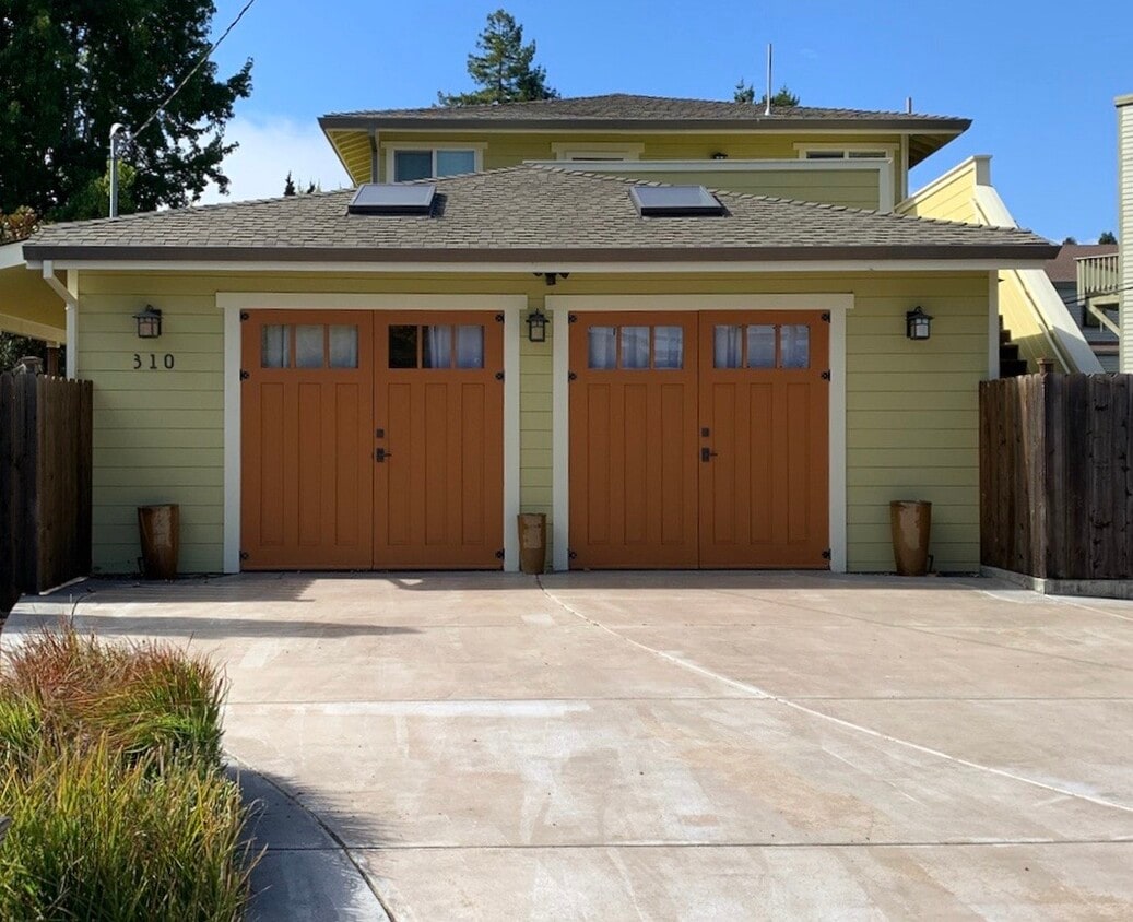
310 Laurel Way Unit #2-upstairs
Mill Valley, CA 94941
1 Day Ago
|
Edit
Favorites
650-731-7085
-
Bedrooms
2
-
Bathrooms
1
-
Square Feet
820 sq ft
-
Available
Available Now
Highlights
- Balcony
- Smoke Free
310 Laurel Way Unit #2-upstairs

Favorites
About This Home
6 Month Lease,
$5,200 deposit,
Available Now
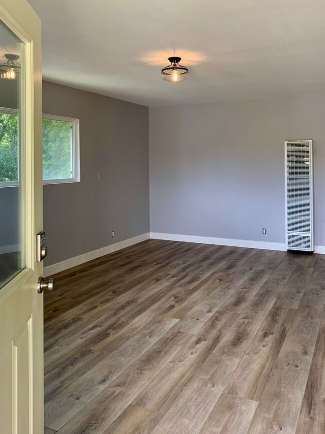
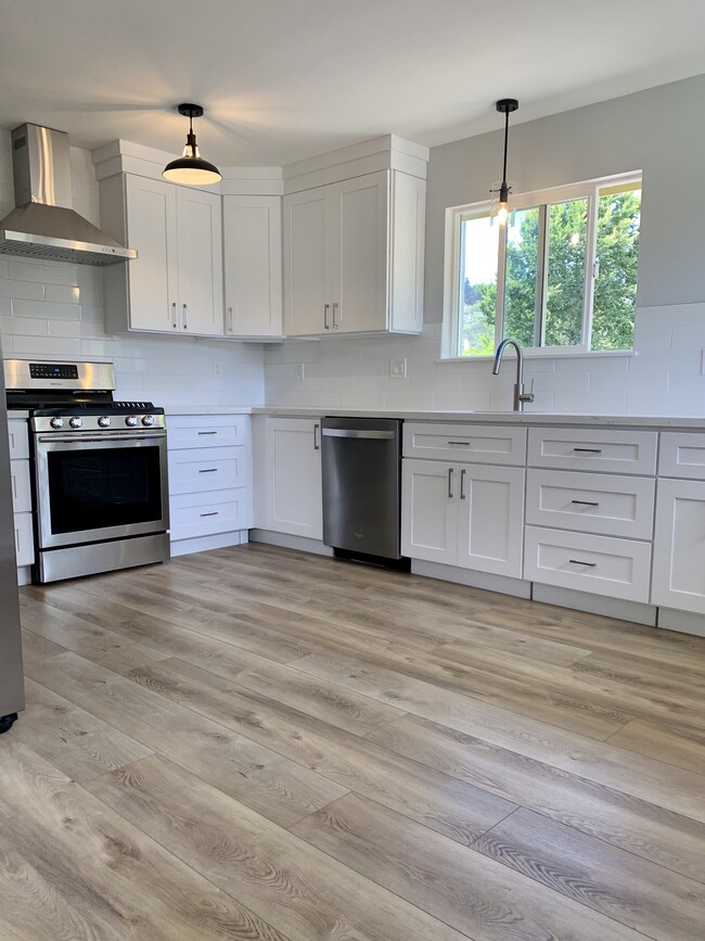
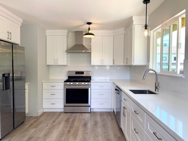
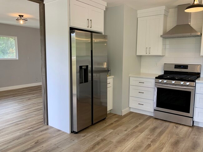
Recently fully remodeled upper unit with beautiful new kitchen, gas range, dishwasher, disposal, refrigerator, and full size in-unit washer/dryer. Windows provide lots of natural lights and all windows have shades. Stairs lead to front porch/entrance area. Off street/Driveway parking space + additional street parking. Pets considered. Just a few miles from Muir Beach, hundreds of miles of walking, hiking and mountain bike trails through Marin's gorgeous open space. Nearby; Miwok Riding Stables, Green Gulch Zen Center, and Tennessee Valley Trail Head. Walking distance to Good Earth Organic Grocery Store, Equator Coffee, Proof Lab Surf Shop, Cafe Del Soul and Hook Fish Co. Brewery.
Recently fully remodeled upper unit with beautiful new kitchen, gas range, dishwasher, disposal, refrigerator, and full size in-unit washer/dryer. Windows provide lots of natural lights and all windows have shades. Stairs lead to front porch/entrance area. Off street/Driveway parking space + additional street parking. Pets considered. Just a few miles from Muir Beach, hundreds of miles of walking, hiking and mountain bike trails through Marin's gorgeous open space. Nearby; Miwok Riding Stables, Green Gulch Zen Center, and Tennessee Valley Trail Head. Walking distance to Good Earth Organic Grocery Store, Equator Coffee, Proof Lab Surf Shop, Cafe Del Soul and Hook Fish Co. Brewery.
310 Laurel Way is an apartment community located in Marin County and the 94941 ZIP Code.
* Price shown is total price based on community-supplied monthly required fees. Excludes user-selected optional fees and variable or usage-based fees and required charges due at or prior to move-in or at move-out. Price, availability, fees, and any applicable rent special are subject to change without notice.
* Square footage definitions vary. Displayed square footage is approximate.
Apartment Features
Washer/Dryer
Dishwasher
Refrigerator
Disposal
- Washer/Dryer
- Smoke Free
- Cable Ready
- Dishwasher
- Disposal
- Ice Maker
- Kitchen
- Range
- Refrigerator
- Walking/Biking Trails
- Balcony
- Porch
Fees and Policies
The fees listed below are community-provided and may exclude utilities or add-ons. All payments are made directly to the property and are non-refundable unless otherwise specified.
- Parking
-
Other--
Details
Utilities Included
-
Water
-
Heat
-
Trash Removal
Property Information
-
2 units
Contact
- Phone Number
- Contact
Location
Get Directions
If you drive out of San Francisco, across the Golden Gate Bridge, and past the majestic mountains along the Redwood Highway, in about 14 miles you'll reach Mill Valley. Situated in the shadow of Mount Tamalpais, Mill Valley is a picture-perfect city offering gorgeous views, art galleries, and exciting festivals and community events. If you want an apartment in Mill Valley, be aware that while it was named one of the top 100 cities in which to live by Money Magazine, it was also listed as one of the "most expensive zip codes in America" by Forbes.
Mill Valley's adorable downtown provides terrific shops, art galleries, boutiques, and restaurants, mainly along Miller Avenue and Throckmorton Avenue. When residents aren't enjoying the downtown area, they're enjoying the numerous parks and hiking trails -- including the famous Dipsea Trail, a challenging seven-mile trail that begins with a steep staircase located in Old Mill Park, a scenic park located along a creek in a grove of redwoods.
Learn more about living in Mill Valley
Education
| Colleges & Universities | Distance | ||
|---|---|---|---|
| Colleges & Universities | Distance | ||
| Drive: | 16 min | 9.3 mi | |
| Drive: | 18 min | 10.3 mi | |
| Drive: | 20 min | 10.6 mi | |
| Drive: | 24 min | 12.3 mi |
310 Laurel Way Unit #2-upstairs is within 16 minutes or 9.3 miles from Dominican Univ. of Ca. It is also near UC San Francisco, Mount Zion and University of San Francisco.
Transportation options available in Mill Valley include Hyde And Bay, located 10.7 miles from 310 Laurel Way Unit #2-upstairs. 310 Laurel Way Unit #2-upstairs is near San Francisco International, located 25.2 miles or 42 minutes away, and Metro Oakland International, located 36.0 miles or 50 minutes away.
| Transit / Subway | Distance | ||
|---|---|---|---|
| Transit / Subway | Distance | ||
|
|
Drive: | 19 min | 10.7 mi |
|
|
Drive: | 19 min | 10.7 mi |
| Drive: | 20 min | 10.8 mi | |
| Drive: | 20 min | 11.0 mi | |
|
|
Drive: | 21 min | 11.2 mi |
| Commuter Rail | Distance | ||
|---|---|---|---|
| Commuter Rail | Distance | ||
| Drive: | 12 min | 6.5 mi | |
| Drive: | 13 min | 8.5 mi | |
| Drive: | 17 min | 11.8 mi | |
| Drive: | 25 min | 13.2 mi | |
| Drive: | 25 min | 16.2 mi |
| Airports | Distance | ||
|---|---|---|---|
| Airports | Distance | ||
|
San Francisco International
|
Drive: | 42 min | 25.2 mi |
|
Metro Oakland International
|
Drive: | 50 min | 36.0 mi |
Getting Around
 What do Walkability, Transit, Drivability, and Bikeability mean?
Walkability measures the walking distance to day-to-day needs.
Transit measures access to public transportation.
Drivability measures congestion, parking availability, and access to major roads.
Bikeability measures the suitability for cycling.
How It Works
What do Walkability, Transit, Drivability, and Bikeability mean?
Walkability measures the walking distance to day-to-day needs.
Transit measures access to public transportation.
Drivability measures congestion, parking availability, and access to major roads.
Bikeability measures the suitability for cycling.
How It Works
Somewhat Walkable
Walkability
30
/ 100
Limited Public Transit
Transit
30
/ 100
Very Drivable
Drivability
80
/ 100
Fairly Bikeable
Bikeability
50
/ 100
Scores provided by
Active
Soundscore™
74
/ 100
Traffic
ActiveAirport
CalmBusinesses
CalmScores provided by
HowLoud What is a Sound Score Rating? A Sound Score Rating aggregates noise caused by vehicle traffic, airplane traffic and local sources. How It WorksTime and distance from 310 Laurel Way Unit #2-upstairs.
| Shopping Centers | Distance | ||
|---|---|---|---|
| Shopping Centers | Distance | ||
| Walk: | 16 min | 0.9 mi | |
| Drive: | 4 min | 1.9 mi | |
| Drive: | 5 min | 2.2 mi |
310 Laurel Way Unit #2-upstairs has 3 shopping centers within 2.2 miles, which is about a 5-minute drive. The miles and minutes will be for the farthest away property.
| Parks and Recreation | Distance | ||
|---|---|---|---|
| Parks and Recreation | Distance | ||
|
Golden Gate National Recreation Area
|
Drive: | 20 min | 3.2 mi |
|
Bay Model Visitor Center
|
Drive: | 7 min | 3.3 mi |
|
Muir Woods National Monument
|
Drive: | 9 min | 4.3 mi |
|
Richardson Bay Audubon Center
|
Drive: | 9 min | 4.3 mi |
|
Friends of Mt. Tam
|
Drive: | 8 min | 4.3 mi |
310 Laurel Way Unit #2-upstairs has 5 parks within 4.3 miles, including Bay Model Visitor Center, Golden Gate National Recreation Area, and Richardson Bay Audubon Center.
| Hospitals | Distance | ||
|---|---|---|---|
| Hospitals | Distance | ||
| Drive: | 14 min | 7.9 mi | |
| Drive: | 18 min | 10.3 mi | |
| Drive: | 20 min | 12.2 mi |
310 Laurel Way Unit #2-upstairs has 3 hospitals within 12.2 miles, the nearest is MarinHealth Medical Center which is 7.9 miles away and a 14 minute drive.
| Military Bases | Distance | ||
|---|---|---|---|
| Military Bases | Distance | ||
| Drive: | 20 min | 10.1 mi | |
| Drive: | 21 min | 10.5 mi | |
| Drive: | 34 min | 17.2 mi |
310 Laurel Way Unit #2-upstairs has 3 military bases within 17.2 miles, the nearest is East Fort Miley which is 10.1 miles away and a 20 minute drive.
Amenities
- Washer/Dryer
- Smoke Free
- Cable Ready
- Dishwasher
- Disposal
- Ice Maker
- Kitchen
- Range
- Refrigerator
- Balcony
- Porch
- Walking/Biking Trails
310 Laurel Way Unit #2-upstairs Photos
What Are Walk Score®, Transit Score®, and Bike Score® Ratings?
Walk Score® measures the walkability of any address. Transit Score® measures access to public transit. Bike Score® measures the bikeability of any address.
What is a Sound Score Rating?
A Sound Score Rating aggregates noise caused by vehicle traffic, airplane traffic and local sources.

310 Laurel Way
Mill Valley, CA 94941