

$2,300
/ Month
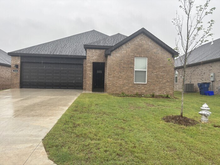
310 Cain Trail
Maumelle, AR 72113
Today
|
Edit
Favorites
501-353-0368
-
Bedrooms
4
-
Bathrooms
2
-
Square Feet
1,862 sq ft
-
Available
Available Now
310 Cain Trail

Favorites
About This Home
Available Now
This property allows self guided viewing without an appointment. Contact for details.
310 Cain Trail is a house located in Pulaski County and the 72113 ZIP Code. This area is served by the Pulaski County Special attendance zone.
* Price shown is base rent. Excludes user-selected optional fees and variable or usage-based fees and required charges due at or prior to move-in or at move-out. Price, availability, fees, and any applicable rent special are subject to change without notice.
* Square footage definitions vary. Displayed square footage is approximate.
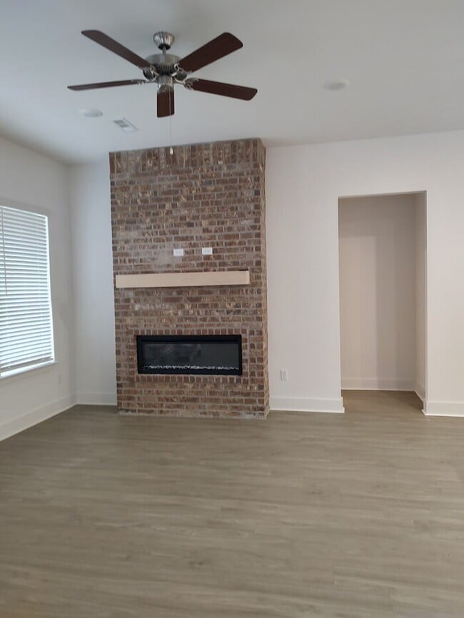
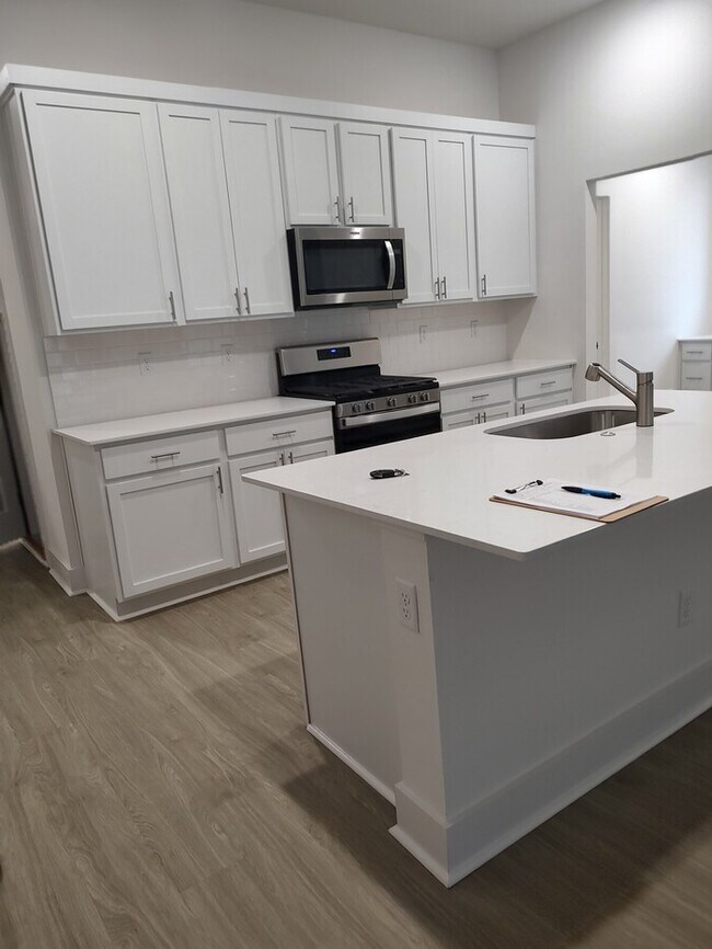
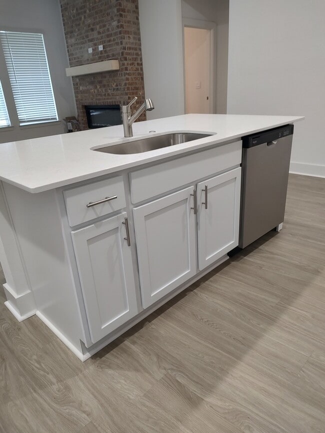
House Features
- Disposal
- Oven
- Patio
Contact
- Listed by Peak Properties | Peak Properties
- Phone Number
- Contact
Location
Get Directions
Amenities
- Disposal
- Oven
- Patio
The rolling, green hills of Maumelle, Arkansas are lined with elegant homes perched on manicured lawns, many with great views of the mountains. Maumelle borders the Arkansas River, directly across from Pinnacle Mountain State Park. Lake Maumelle is also nearby, providing ample opportunities for boating and fishing. Maumelle is located about 15 miles northwest of Little Rock, and residents have easy access to I-40.
Located in the middle of Maumelle, Lake Willastien is a popular boating and fishing destination. The lake is bordered by a park with a playground, walking paths, picnic areas, fishing docks, and a gazebo. While Maumelle is primarily a residential suburb, a variety of shops and restaurants are available along the Arkansas River Trail on the north end of the city.
Learn more about living in Maumelle
Education
| Colleges & Universities | Distance | ||
|---|---|---|---|
| Colleges & Universities | Distance | ||
| Drive: | 17 min | 10.3 mi | |
| Drive: | 21 min | 12.5 mi | |
| Drive: | 19 min | 12.8 mi | |
| Drive: | 22 min | 13.6 mi |
310 Cain Trail is within 17 minutes or 10.3 miles from Pulaski Technical College. It is also near Univ. of Ark. Medical Scis. and UA Little Rock.
Schools


Public Elementary School
Grades PK-5
504 Students
Attendance Zone
Public Middle School
Grades 6-9
589 Students
Attendance Zone
Private Elementary, Middle & High School
Grades K-12
43 Students
Nearby
Private Elementary & Middle School
Grades PK-8
131 Students
Nearby
School data provided by
 The GreatSchools Rating helps parents compare schools within a state based on a variety of school quality indicators and provides a helpful picture of how effectively each school serves all of its students. Ratings are on a scale of 1 (below average) to 10 (above average) and can include test scores, college readiness, academic progress, advanced courses, equity, discipline and attendance data. We also advise parents to visit schools, consider other information on school performance and programs, and consider family needs as part of the school selection process.
View GreatSchools Rating Methodology
Data provided by GreatSchools.org © 2025. All rights reserved.
View GreatSchools Rating Methodology
Data provided by GreatSchools.org © 2025. All rights reserved.
Transportation options available in Maumelle include Main St & Bishop Lindsey Ave, located 10.5 miles from 310 Cain Trail. 310 Cain Trail is near Bill and Hillary Clinton Ntl/Adams Field, located 16.3 miles or 23 minutes away.
| Transit / Subway | Distance | ||
|---|---|---|---|
| Transit / Subway | Distance | ||
| Drive: | 14 min | 10.5 mi | |
| Drive: | 15 min | 10.6 mi | |
| Drive: | 15 min | 10.7 mi | |
| Drive: | 15 min | 10.8 mi | |
| Drive: | 15 min | 10.9 mi |
| Commuter Rail | Distance | ||
|---|---|---|---|
| Commuter Rail | Distance | ||
|
|
Drive: | 18 min | 12.2 mi |
| Airports | Distance | ||
|---|---|---|---|
| Airports | Distance | ||
|
Bill and Hillary Clinton Ntl/Adams Field
|
Drive: | 23 min | 16.3 mi |
Time and distance from 310 Cain Trail.
| Shopping Centers | Distance | ||
|---|---|---|---|
| Shopping Centers | Distance | ||
| Drive: | 5 min | 2.3 mi | |
| Drive: | 5 min | 2.5 mi | |
| Drive: | 6 min | 2.9 mi |
310 Cain Trail has 3 shopping centers within 2.9 miles, which is about a 6-minute drive. The miles and minutes will be for the farthest away property.
| Parks and Recreation | Distance | ||
|---|---|---|---|
| Parks and Recreation | Distance | ||
|
Burns Park
|
Drive: | 12 min | 7.5 mi |
|
Museum of Discovery
|
Drive: | 17 min | 11.6 mi |
|
Little Rock Zoo
|
Drive: | 20 min | 12.9 mi |
|
Pinnacle Mountain State Park
|
Drive: | 26 min | 13.5 mi |
|
Central High School National Historic Site
|
Drive: | 21 min | 13.9 mi |
310 Cain Trail has 5 parks within 13.9 miles, including Burns Park, Little Rock Zoo, and Museum of Discovery.
| Hospitals | Distance | ||
|---|---|---|---|
| Hospitals | Distance | ||
| Drive: | 9 min | 4.7 mi | |
| Drive: | 9 min | 4.9 mi | |
| Drive: | 11 min | 5.4 mi |
310 Cain Trail has 3 hospitals within 5.4 miles, the nearest is United Methodist Behavioral Hospital which is 4.7 miles away and a 9 minute drive.
| Military Bases | Distance | ||
|---|---|---|---|
| Military Bases | Distance | ||
| Drive: | 26 min | 11.6 mi | |
| Drive: | 31 min | 19.2 mi | |
| Drive: | 37 min | 25.1 mi |
310 Cain Trail has 3 military bases within 25.1 miles, the nearest is Camp Joseph T. Robinson Hill which is 11.6 miles away and a 26 minute drive.
You May Also Like
Similar Rentals Nearby


What Are Walk Score®, Transit Score®, and Bike Score® Ratings?
Walk Score® measures the walkability of any address. Transit Score® measures access to public transit. Bike Score® measures the bikeability of any address.
What is a Sound Score Rating?
A Sound Score Rating aggregates noise caused by vehicle traffic, airplane traffic and local sources

310 Cain Trail
Maumelle, AR 72113