

$1,800
Total Monthly Price
31 Devens St Unit Side
Staten Island, NY 10314
Favorites
-
Bedrooms
1
-
Bathrooms
1
-
Square Feet
450 sq ft
-
Available
Available Now
Highlight
- Smoke Free
31 Devens St Unit Side

Favorites
About This Home
12 Month Lease,
$1,800 deposit,
Available Now
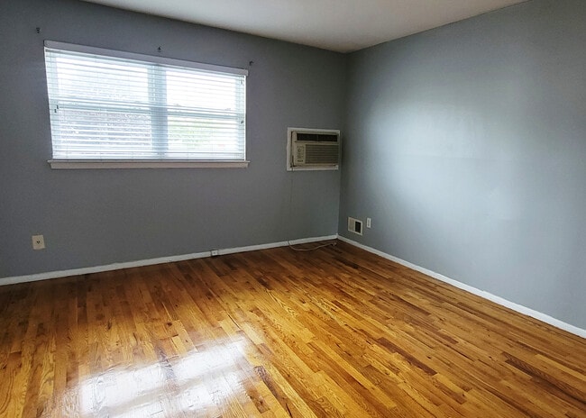
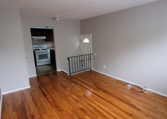
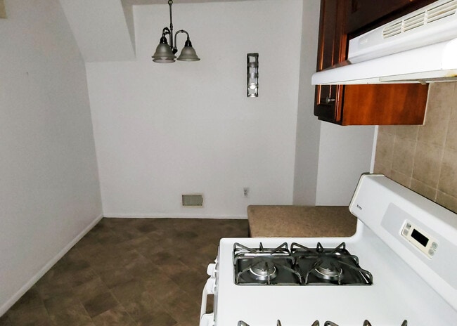
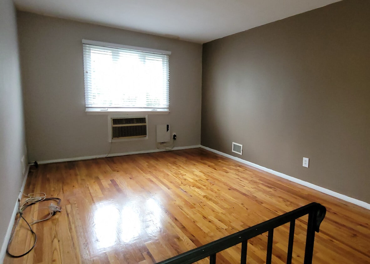
Beautiful 1 bed 1 bath apartment for rent sought after Westerleigh. Side entrance into a large walk up living room. Eat in kitchen. Huge bedroom with 2 closets. Private driveway. Quiet block. Walking distance to buses. No smoking, No Pets.
31 Devens St is an apartment community located in Richmond County and the 10314 ZIP Code. This area is served by the New York City Geographic District #31 attendance zone.
* Price shown is total price based on community-supplied monthly required fees. Excludes user-selected optional fees and variable or usage-based fees and required charges due at or prior to move-in or at move-out. Price, availability, fees, and any applicable rent special are subject to change without notice.
* Square footage definitions vary. Displayed square footage is approximate.
Apartment Features
- Smoke Free
- Eat-in Kitchen
- Walk-Up
Fees and Policies
The fees listed below are community-provided and may exclude utilities or add-ons. All payments are made directly to the property and are non-refundable unless otherwise specified.
- Parking
-
Other--
Details
Utilities Included
-
Water
-
Sewer
Property Information
-
2 units
Contact
- Contact
Location
Get Directions
Staten Island occupies a singular position as New York City's southernmost borough, physically separate from the rest of the city yet firmly connected to it through the iconic, round-the-clock Staten Island Ferry. As the least densely populated of the five boroughs, it carries a noticeably quieter, more residential character than Manhattan or Brooklyn, covering roughly 59 square miles with a population near 490,000. The College of Staten Island anchors the borough's educational presence, while Snug Harbor Cultural Center and Botanical Garden reflects a deep commitment to the arts and green space. During the American Revolution, Staten Island served as a primary staging ground for British forces and remained under British control longer than any other part of what would become the United States.
Neighborhoods vary considerably across the island. St. George on the North Shore functions as the civic and cultural hub, while Tottenville anchors the quieter South Shore.
Learn more about living in Staten Island
Education
| Colleges & Universities | Distance | ||
|---|---|---|---|
| Colleges & Universities | Distance | ||
| Drive: | 6 min | 1.8 mi | |
| Drive: | 10 min | 3.6 mi | |
| Drive: | 12 min | 6.1 mi | |
| Drive: | 15 min | 7.7 mi |
31 Devens St Unit Side is within 6 minutes or 1.8 miles from Coll. of Staten Island, CUNY. It is also near Wagner College and Union County Coll., Elizabeth.
Schools


Public Elementary School
Grades PK-5
717 Students
Attendance Zone
Public Elementary School
Grades PK-5
377 Students
Attendance Zone
Public Middle School
Grades 6-8
1,073 Students
Attendance Zone
Public High School
Grades 9-12
1,693 Students
Attendance Zone
Private Elementary & Middle School
Grades K-8
78 Students
Nearby
Private High School
Grades 9-12
60 Students
Nearby
School data provided by
 The GreatSchools Rating helps parents compare schools within a state based on a variety of school quality indicators and provides a helpful picture of how effectively each school serves all of its students. Ratings are on a scale of 1 (below average) to 10 (above average) and can include test scores, college readiness, academic progress, advanced courses, equity, discipline and attendance data. We also advise parents to visit schools, consider other information on school performance and programs, and consider family needs as part of the school selection process.
View GreatSchools Rating Methodology
Data provided by GreatSchools.org © 2026. All rights reserved.
View GreatSchools Rating Methodology
Data provided by GreatSchools.org © 2026. All rights reserved.
Transportation options available in Staten Island include 8Th Street Light Rail Station, located 3.0 miles from 31 Devens St Unit Side. 31 Devens St Unit Side is near Newark Liberty International, located 11.3 miles or 18 minutes away, and LaGuardia, located 24.2 miles or 41 minutes away.
| Transit / Subway | Distance | ||
|---|---|---|---|
| Transit / Subway | Distance | ||
| Drive: | 6 min | 3.0 mi | |
|
|
Drive: | 8 min | 4.2 mi |
|
|
Drive: | 9 min | 5.1 mi |
|
|
Drive: | 11 min | 6.5 mi |
|
|
Drive: | 13 min | 7.2 mi |
| Commuter Rail | Distance | ||
|---|---|---|---|
| Commuter Rail | Distance | ||
|
|
Drive: | 9 min | 4.3 mi |
|
|
Drive: | 12 min | 4.3 mi |
|
|
Drive: | 13 min | 4.6 mi |
|
|
Drive: | 13 min | 4.8 mi |
|
|
Drive: | 11 min | 5.4 mi |
| Airports | Distance | ||
|---|---|---|---|
| Airports | Distance | ||
|
Newark Liberty International
|
Drive: | 18 min | 11.3 mi |
|
LaGuardia
|
Drive: | 41 min | 24.2 mi |
Getting Around
 What do Walkability, Transit, Drivability, and Bikeability mean?
Walkability measures the walking distance to day-to-day needs.
Transit measures access to public transportation.
Drivability measures congestion, parking availability, and access to major roads.
Bikeability measures the suitability for cycling.
How It Works
What do Walkability, Transit, Drivability, and Bikeability mean?
Walkability measures the walking distance to day-to-day needs.
Transit measures access to public transportation.
Drivability measures congestion, parking availability, and access to major roads.
Bikeability measures the suitability for cycling.
How It Works
Moderately Walkable
Walkability
70
/ 100
Some Public Transit
Transit
50
/ 100
Moderately Drivable
Drivability
60
/ 100
Fairly Bikeable
Bikeability
50
/ 100
Scores provided by
-
Soundscore™
-
/ 100
Traffic
-Airport
-Businesses
-Scores provided by
HowLoud What is a Sound Score Rating? A Sound Score Rating aggregates noise caused by vehicle traffic, airplane traffic and local sources. How It WorksTime and distance from 31 Devens St Unit Side.
| Shopping Centers | Distance | ||
|---|---|---|---|
| Shopping Centers | Distance | ||
| Walk: | 13 min | 0.7 mi | |
| Walk: | 13 min | 0.7 mi | |
| Walk: | 13 min | 0.7 mi |
31 Devens St Unit Side has 3 shopping centers within 0.7 mile, which is about a 13-minute walk. The miles and minutes will be for the farthest away property.
| Parks and Recreation | Distance | ||
|---|---|---|---|
| Parks and Recreation | Distance | ||
|
Westerleigh Park
|
Walk: | 14 min | 0.7 mi |
|
Astrophysical Observatory at College of Staten Island
|
Drive: | 6 min | 1.8 mi |
|
Willowbrook Park
|
Drive: | 6 min | 2.1 mi |
|
Faber Park
|
Drive: | 5 min | 2.1 mi |
|
Staten Island Industrial Park
|
Drive: | 6 min | 2.4 mi |
31 Devens St Unit Side has 5 parks within 2.4 miles, including Westerleigh Park, Willowbrook Park, and Faber Park.
| Hospitals | Distance | ||
|---|---|---|---|
| Hospitals | Distance | ||
| Drive: | 7 min | 2.9 mi | |
| Drive: | 8 min | 4.8 mi | |
| Drive: | 13 min | 6.5 mi |
31 Devens St Unit Side has 3 hospitals within 6.5 miles, the nearest is Richmond University Medical Center which is 2.9 miles away and a 7 minute drive.
| Military Bases | Distance | ||
|---|---|---|---|
| Military Bases | Distance | ||
| Drive: | 14 min | 4.8 mi | |
| Drive: | 12 min | 6.2 mi | |
| Drive: | 16 min | 8.2 mi |
31 Devens St Unit Side has 3 military bases within 8.2 miles, the nearest is Naval Station NY Stapleton Site which is 4.8 miles away and a 14 minute drive.
Amenities
- Smoke Free
- Eat-in Kitchen
- Walk-Up
31 Devens St Unit Side Photos
What Are Walk Score®, Transit Score®, and Bike Score® Ratings?
Walk Score® measures the walkability of any address. Transit Score® measures access to public transit. Bike Score® measures the bikeability of any address.
What is a Sound Score Rating?
A Sound Score Rating aggregates noise caused by vehicle traffic, airplane traffic and local sources.
31 Devens St
Staten Island, NY 10314