
$7,999
/ Month
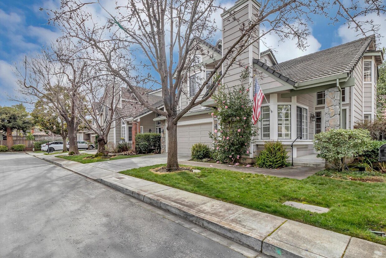
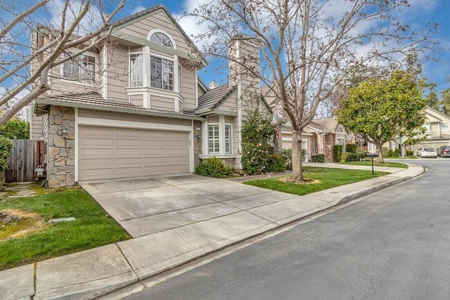
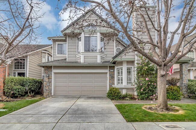
302 Tadley Ct
Redwood City, CA 94061
Today
|
Edit
Favorites
650-924-1340
-
Bedrooms
4
-
Bathrooms
2
-
Square Feet
2,470 sq ft
-
Available
Available Jun 15
302 Tadley Ct

Favorites
About This Home
Available Jun 15
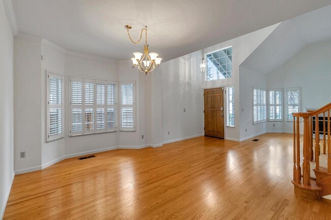
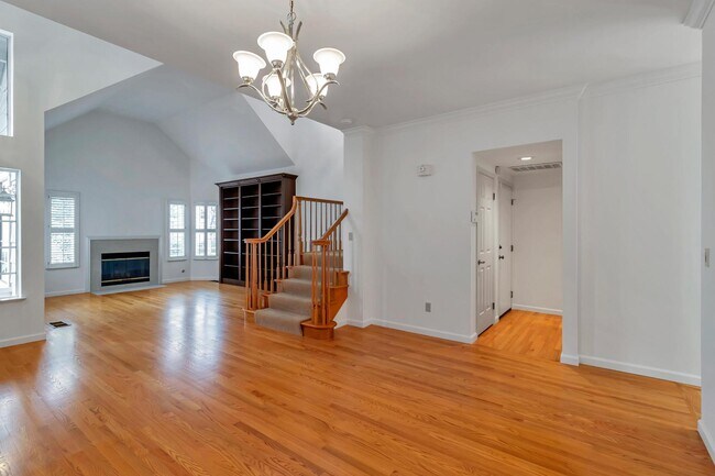
Families will love this four bedroom, two-and-a-half bath home featuring an upgraded kitchen, built-in bookcases, tons of storage, a two-car garage, and a beautiful garden to enjoy indoor-outdoor living. The master bathroom is huge with a separate soaking tub and shower. The garage has an entire bank of shelves and an extra refrigerator. The home has solar panels to bring down the cost of your electricity bill and central air conditioner. Unit comes with one wall mounted television. The unit has access to a community pool. You won't want to miss this beautiful family home! Leases can start anytime between 6/7 and 8/15.
302 Tadley Ct is a house located in San Mateo County and the 94061 ZIP Code. This area is served by the Redwood City Elementary School District attendance zone.
* Price shown is base rent. Excludes user-selected optional fees and variable or usage-based fees and required charges due at or prior to move-in or at move-out. Price, availability, fees, and any applicable rent special are subject to change without notice.
* Square footage definitions vary. Displayed square footage is approximate.
Contact
- Listed by Harper | Harper Properties Inc
- Phone Number
- Contact
Location
Get Directions
Redwood Oaks is a small neighborhood located about two miles south of Downtown Redwood City. Redwood Oaks is predominately residential but there are some restaurants and stores located along Woodside Road and Highway 84. The neighborhood has several small parks, great schools, and easy access to several major Bay Area cities including San Francisco and San Jose, so it’s a popular choice for families and commuters. San Francisco and San Jose are about a 30-minute drive away. Redwood Oaks is also just five miles away from Stanford University, making it convenient for students. This charming neighborhood has a variety of luxury apartments, condos, townhomes, and single-family houses available for rent.
Learn more about living in Redwood Oaks
Education
| Colleges & Universities | Distance | ||
|---|---|---|---|
| Colleges & Universities | Distance | ||
| Drive: | 8 min | 3.2 mi | |
| Drive: | 10 min | 4.4 mi | |
| Drive: | 17 min | 6.7 mi | |
| Drive: | 18 min | 10.8 mi |
302 Tadley Ct is within 8 minutes or 3.2 miles from Menlo College. It is also near Canada College and Stanford University.
Schools


Public Elementary School
Grades K-5
582 Students
Nearby
Public Middle School
Grades 6-8
808 Students
Nearby
Public High School
Grades 9-12
224 Students
Nearby
School data provided by
 The GreatSchools Rating helps parents compare schools within a state based on a variety of school quality indicators and provides a helpful picture of how effectively each school serves all of its students. Ratings are on a scale of 1 (below average) to 10 (above average) and can include test scores, college readiness, academic progress, advanced courses, equity, discipline and attendance data. We also advise parents to visit schools, consider other information on school performance and programs, and consider family needs as part of the school selection process.
View GreatSchools Rating Methodology
Data provided by GreatSchools.org © 2026. All rights reserved.
View GreatSchools Rating Methodology
Data provided by GreatSchools.org © 2026. All rights reserved.
Transportation options available in Redwood City include Mountain View Station, located 13.5 miles from 302 Tadley Ct. 302 Tadley Ct is near San Francisco International, located 16.7 miles or 24 minutes away, and Norman Y Mineta San Jose International, located 20.7 miles or 29 minutes away.
| Transit / Subway | Distance | ||
|---|---|---|---|
| Transit / Subway | Distance | ||
| Drive: | 19 min | 13.5 mi |
| Commuter Rail | Distance | ||
|---|---|---|---|
| Commuter Rail | Distance | ||
| Drive: | 6 min | 2.2 mi | |
| Drive: | 9 min | 3.6 mi | |
| Drive: | 10 min | 4.4 mi | |
| Drive: | 11 min | 4.8 mi | |
| Drive: | 12 min | 7.1 mi |
| Airports | Distance | ||
|---|---|---|---|
| Airports | Distance | ||
|
San Francisco International
|
Drive: | 24 min | 16.7 mi |
|
Norman Y Mineta San Jose International
|
Drive: | 29 min | 20.7 mi |
Getting Around
 What do Walkability, Transit, Drivability, and Bikeability mean?
Walkability measures the walking distance to day-to-day needs.
Transit measures access to public transportation.
Drivability measures congestion, parking availability, and access to major roads.
Bikeability measures the suitability for cycling.
How It Works
What do Walkability, Transit, Drivability, and Bikeability mean?
Walkability measures the walking distance to day-to-day needs.
Transit measures access to public transportation.
Drivability measures congestion, parking availability, and access to major roads.
Bikeability measures the suitability for cycling.
How It Works
Moderately Walkable
Walkability
60
/ 100
Limited Public Transit
Transit
30
/ 100
Moderately Drivable
Drivability
70
/ 100
Fairly Bikeable
Bikeability
40
/ 100
Scores provided by
-
Soundscore™
-
/ 100
Traffic
-Airport
-Businesses
-Scores provided by
HowLoud What is a Sound Score Rating? A Sound Score Rating aggregates noise caused by vehicle traffic, airplane traffic and local sources. How It WorksTime and distance from 302 Tadley Ct.
| Shopping Centers | Distance | ||
|---|---|---|---|
| Shopping Centers | Distance | ||
| Walk: | 8 min | 0.4 mi | |
| Walk: | 12 min | 0.6 mi | |
| Walk: | 18 min | 0.9 mi |
302 Tadley Ct has 3 shopping centers within 0.9 mile, which is about a 18-minute walk. The miles and minutes will be for the farthest away property.
| Parks and Recreation | Distance | ||
|---|---|---|---|
| Parks and Recreation | Distance | ||
|
Red Morton Park
|
Drive: | 6 min | 1.6 mi |
|
Stulsaft Park
|
Drive: | 7 min | 2.5 mi |
|
Holbrook-Palmer Park
|
Drive: | 8 min | 3.2 mi |
|
Sharon Hills Park
|
Drive: | 9 min | 3.5 mi |
|
Fremont Park
|
Drive: | 10 min | 4.0 mi |
302 Tadley Ct has 5 parks within 4.0 miles, including Red Morton Park, Stulsaft Park, and Holbrook-Palmer Park.
| Hospitals | Distance | ||
|---|---|---|---|
| Hospitals | Distance | ||
| Drive: | 6 min | 2.3 mi | |
| Drive: | 8 min | 2.8 mi | |
| Drive: | 13 min | 5.4 mi |
302 Tadley Ct has 3 hospitals within 5.4 miles, the nearest is Kaiser Foundation Hospital - Redwood City which is 2.3 miles away and a 6 minute drive.
| Military Bases | Distance | ||
|---|---|---|---|
| Military Bases | Distance | ||
| Drive: | 22 min | 13.6 mi |
302 Tadley Ct is 13.6 miles and a 22 minute drive from Ames Research Center.
You May Also Like
Similar Rentals Nearby


What Are Walk Score®, Transit Score®, and Bike Score® Ratings?
Walk Score® measures the walkability of any address. Transit Score® measures access to public transit. Bike Score® measures the bikeability of any address.
What is a Sound Score Rating?
A Sound Score Rating aggregates noise caused by vehicle traffic, airplane traffic and local sources.

302 Tadley Ct
Redwood City, CA 94061