


$8,895 / Month
30 Parsons Way
Los Altos, CA 94022
2 Weeks Ago
Favorites
30 Parsons Way

Favorites
Check Back Soon for Upcoming Availability
| Beds | Baths | Average SF |
|---|---|---|
| 4 Bedrooms 4 Bedrooms 4 Br | 2.5 Baths 2.5 Baths 2.5 Ba | — |
About This Property
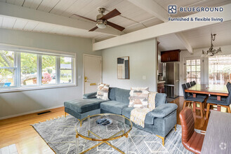
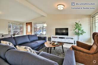
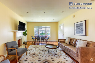
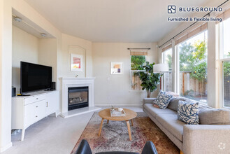
This fabulous home features all the best Eichler touches: Great windows with loads of light, vaulted ceilings to make spacious rooms feel even bigger, open floor plan to join the living room and dining room. There is updated heating with a tankless system, separately zoned for each side of the house. Radiant floor heat makes the house cozy and comfortable. Three nice size guest/kids rooms and a hall bath, and the primary bedroom and primary bath are on the right side of the house. The living room, dining area, kitchen, half bath, and laundry room on the left side. The bedrooms feature new cushy carpet, the rest of the house has beautiful Spanish tile floors for easy upkeep. The kitchen has Corian countertops, updated appliances and loads of counter space and storage! This very comfortable home is at the end of a cul de sac, with "walk to school" location, close to downtown and also San Antonio Center. And did I mention the beautiful landscaping and the POOL? A backyard meant for California living and entertaining! Los Altos Schools (tenant to verify availability) Almond Elementary School. rated 7/10 Grades: K-6 Distance: 0.7 mi Ardis G. Egan Junior High School rated 8/10 Grades: 7-8 Distance: 0.6 mi Los Altos High School rated 9/10 Grades: 9-12 Distance: 0.3 mi Please, no pets, no smoking. Contact Teri Berwick (DRE 01705674) at for an appointment to view. Professionally managed by Summerhill Property Management, Inc. (DRE 01523660)
30 Parsons Way is a house located in Santa Clara County and the 94022 ZIP Code. This area is served by the Los Altos Elementary attendance zone.
Location
Get Directions
North Los Altos contains the city’s vibrant commercial centers. The many shops and eateries of Main Street are in the southern portion of North Los Altos, while the diverse restaurants and cafes of San Antonio Road are in the northern stretches near San Antonio Center.
Outside of these commercial areas, North Los Altos is predominantly residential, offering an array of apartments available for rent along tree-lined avenues. Many of the rentals in North Los Altos feature stunning mountain views, as well as close proximity to Mountain View, Foothill College, Stanford University, and Palo Alto. Getting around from North Los Altos is simple with access to El Camino Real, Interstate 280, and San Antonio Station.
Learn more about living in North Los AltosBelow are rent ranges for similar nearby apartments
| Beds | Average Size | Lowest | Typical | Premium |
|---|---|---|---|---|
| Studio Studio Studio | 453 Sq Ft | $1,940 | $3,193 | $5,596 |
| 1 Bed 1 Bed 1 Bed | 754-757 Sq Ft | $2,200 | $3,827 | $6,165 |
| 2 Beds 2 Beds 2 Beds | 1129-1137 Sq Ft | $2,799 | $4,572 | $6,108 |
| 3 Beds 3 Beds 3 Beds | 1334 Sq Ft | $4,546 | $5,447 | $6,000 |
| 4 Beds 4 Beds 4 Beds | 1997 Sq Ft | $6,690 | $10,842 | $14,995 |
Education
| Colleges & Universities | Distance | ||
|---|---|---|---|
| Colleges & Universities | Distance | ||
| Drive: | 6 min | 2.5 mi | |
| Drive: | 7 min | 3.0 mi | |
| Drive: | 12 min | 4.9 mi | |
| Drive: | 15 min | 7.4 mi |
30 Parsons Way is within 6 minutes or 2.5 miles from Foothill College, Middlefield. It is also near Foothill Coll., Los Altos and Stanford University.
Schools

Public Elementary School
Grades K-5
367 Students
Nearby
Public Elementary School
Grades K-6
353 Students
Attendance Zone
Public Middle School
Grades 7-8
497 Students
Attendance Zone
Public High School
Grades 9-12
2,141 Students
Attendance Zone
Private Elementary & Middle School
Grades PK-8
188 Students
Nearby
Private Elementary School
Grades K-6
80 Students
Nearby
Private Elementary & Middle School
Grades 1-8
136 Students
Nearby
Private Middle & High School
Grades 6-12
140 Students
Nearby
School data provided by
 The GreatSchools Rating helps parents compare schools within a state based on a variety of school quality indicators and provides a helpful picture of how effectively each school serves all of its students. Ratings are on a scale of 1 (below average) to 10 (above average) and can include test scores, college readiness, academic progress, advanced courses, equity, discipline and attendance data. We also advise parents to visit schools, consider other information on school performance and programs, and consider family needs as part of the school selection process.
View GreatSchools Rating Methodology
View GreatSchools Rating Methodology
Transportation options available in Los Altos include Mountain View Station, located 3.4 miles from 30 Parsons Way. 30 Parsons Way is near Norman Y Mineta San Jose International, located 12.9 miles or 20 minutes away, and San Francisco International, located 25.1 miles or 34 minutes away.
| Transit / Subway | Distance | ||
|---|---|---|---|
| Transit / Subway | Distance | ||
|
|
Drive: | 6 min | 3.4 mi |
|
|
Drive: | 9 min | 4.6 mi |
|
|
Drive: | 11 min | 5.3 mi |
|
|
Drive: | 10 min | 5.4 mi |
|
|
Drive: | 12 min | 6.3 mi |
| Commuter Rail | Distance | ||
|---|---|---|---|
| Commuter Rail | Distance | ||
| Drive: | 3 min | 1.5 mi | |
| Drive: | 9 min | 3.6 mi | |
| Drive: | 9 min | 3.9 mi | |
| Drive: | 12 min | 5.3 mi | |
| Drive: | 13 min | 6.6 mi |
| Airports | Distance | ||
|---|---|---|---|
| Airports | Distance | ||
|
Norman Y Mineta San Jose International
|
Drive: | 20 min | 12.9 mi |
|
San Francisco International
|
Drive: | 34 min | 25.1 mi |
Time and distance from 30 Parsons Way.
| Shopping Centers | Distance | ||
|---|---|---|---|
| Shopping Centers | Distance | ||
| Drive: | 2 min | 1.1 mi | |
| Drive: | 2 min | 1.2 mi | |
| Drive: | 3 min | 1.2 mi |
30 Parsons Way has 3 shopping centers within 1.2 miles, which is about a 3-minute drive. The miles and minutes will be for the farthest away property.
| Parks and Recreation | Distance | ||
|---|---|---|---|
| Parks and Recreation | Distance | ||
|
Redwood Grove
|
Drive: | 5 min | 1.9 mi |
|
Terman Park
|
Drive: | 6 min | 2.5 mi |
|
Foothill College Observatory
|
Drive: | 8 min | 3.2 mi |
|
Bol Park
|
Drive: | 8 min | 3.3 mi |
|
Esther Clark Nature Preserve
|
Drive: | 7 min | 3.3 mi |
30 Parsons Way has 5 parks within 3.3 miles, including Redwood Grove, Terman Park, and Esther Clark Nature Preserve.
| Hospitals | Distance | ||
|---|---|---|---|
| Hospitals | Distance | ||
| Drive: | 9 min | 3.7 mi | |
| Drive: | 13 min | 5.6 mi | |
| Drive: | 15 min | 6.9 mi |
30 Parsons Way has 3 hospitals within 6.9 miles, the nearest is El Camino Hospital which is 3.7 miles away and a 9 minute drive.
| Military Bases | Distance | ||
|---|---|---|---|
| Military Bases | Distance | ||
| Drive: | 13 min | 5.7 mi |
30 Parsons Way is 5.7 miles and a 13 minute drive from Ames Research Center.
You May Also Like
Similar Rentals Nearby


What Are Walk Score®, Transit Score®, and Bike Score® Ratings?
Walk Score® measures the walkability of any address. Transit Score® measures access to public transit. Bike Score® measures the bikeability of any address.
What is a Sound Score Rating?
A Sound Score Rating aggregates noise caused by vehicle traffic, airplane traffic and local sources

30 Parsons Way
Los Altos, CA 94022