


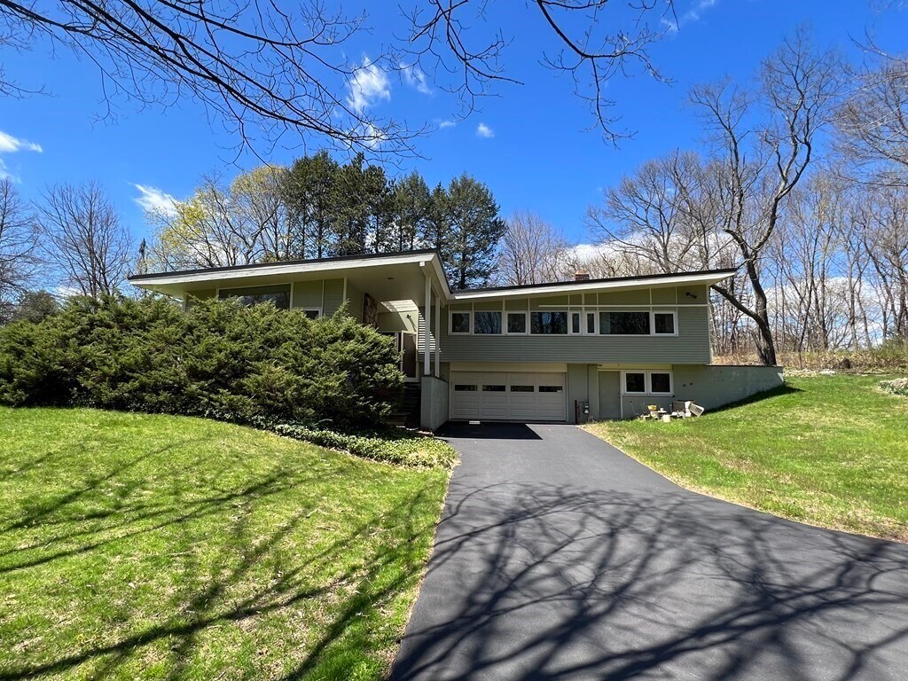
$4,600 / Month
30 Kendal Common Rd
Weston, MA 02493
2 Weeks Ago
Favorites
30 Kendal Common Rd

Favorites
Check Back Soon for Upcoming Availability
| Beds | Baths | Average SF |
|---|---|---|
| 4 Bedrooms 4 Bedrooms 4 Br | 2.5 Baths 2.5 Baths 2.5 Ba | 4,266 SF |
About This Property
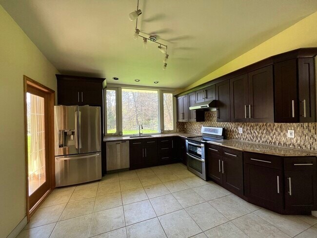
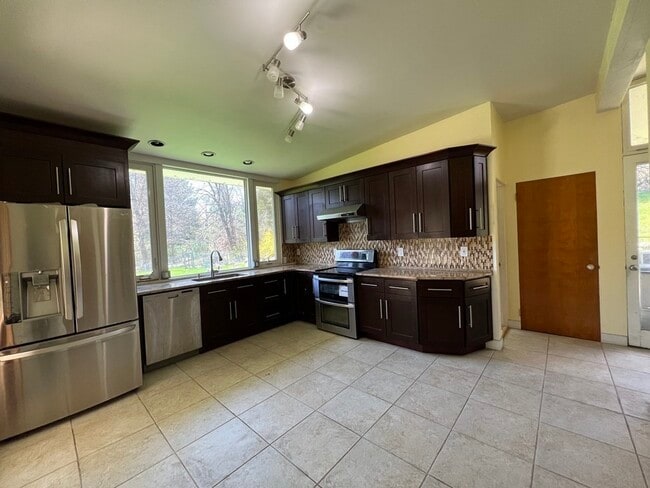
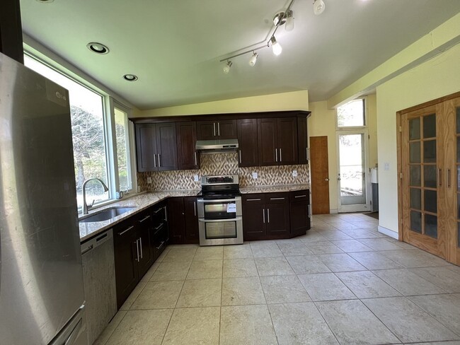
Can't get your offers accepted? This sun filled 4 bedrooms house is available for immediate move in! House is on a large lot featuring updated kitchen,hardwood floor throughout,walking to Kendal green commute-rail station and playground,2 attached garage parkings and landscaping included in the rent! Easy access to highway,house is to shops,Costco and more. Enjoy one of the best school system in MA! Pets will be considered case by case.
30 Kendal Common Rd is a house located in Middlesex County and the 02493 ZIP Code. This area is served by the Weston attendance zone.
Location
Get Directions
Just west of Boston and East of Worcester sits Metro West, a region that houses a group of towns and cities with significant historical backgrounds. A total of 19 municipalities make up the core of this community, but other municipalities are considered to be a part of the Interstate 495/Metro West Corridor.
Learn more about living in Metro WestBelow are rent ranges for similar nearby apartments
| Beds | Average Size | Lowest | Typical | Premium |
|---|---|---|---|---|
| Studio Studio Studio | 515-518 Sq Ft | $1,400 | $2,511 | $8,898 |
| 1 Bed 1 Bed 1 Bed | 873-875 Sq Ft | $1,495 | $3,001 | $9,275 |
| 2 Beds 2 Beds 2 Beds | 1273-1275 Sq Ft | $1,900 | $3,682 | $12,413 |
| 3 Beds 3 Beds 3 Beds | 1580-1585 Sq Ft | $2,500 | $4,846 | $18,973 |
| 4 Beds 4 Beds 4 Beds | 3649 Sq Ft | $1,125 | $6,733 | $17,000 |
Education
| Colleges & Universities | Distance | ||
|---|---|---|---|
| Colleges & Universities | Distance | ||
| Drive: | 8 min | 3.1 mi | |
| Drive: | 9 min | 4.0 mi | |
| Drive: | 17 min | 8.4 mi | |
| Drive: | 17 min | 8.7 mi |
30 Kendal Common Rd is within 8 minutes or 3.1 miles from Brandeis University. It is also near Bentley University and Boston College.
Schools


Public Elementary School
Grades 4-5
266 Students
Attendance Zone
Public Elementary School
Grades PK-3
331 Students
Attendance Zone
Public Middle School
Grades 6-8
444 Students
Attendance Zone
Public High School
Grades 9-12
639 Students
Attendance Zone
Private Elementary & Middle School
Grades PK-8
320 Students
Nearby
Private Elementary, Middle & High School
Grades 3-12
73 Students
Nearby
Private Elementary, Middle & High School
Grades 3-12
107 Students
Nearby
Private High School
Grades 9-12
329 Students
Nearby
School data provided by
 The GreatSchools Rating helps parents compare schools within a state based on a variety of school quality indicators and provides a helpful picture of how effectively each school serves all of its students. Ratings are on a scale of 1 (below average) to 10 (above average) and can include test scores, college readiness, academic progress, advanced courses, equity, discipline and attendance data. We also advise parents to visit schools, consider other information on school performance and programs, and consider family needs as part of the school selection process.
View GreatSchools Rating Methodology
Data provided by GreatSchools.org © 2025. All rights reserved.
View GreatSchools Rating Methodology
Data provided by GreatSchools.org © 2025. All rights reserved.
Transportation options available in Weston include Riverside Station, located 5.4 miles from 30 Kendal Common Rd. 30 Kendal Common Rd is near General Edward Lawrence Logan International, located 16.4 miles or 29 minutes away, and Worcester Regional, located 41.2 miles or 59 minutes away.
| Transit / Subway | Distance | ||
|---|---|---|---|
| Transit / Subway | Distance | ||
|
|
Drive: | 10 min | 5.4 mi |
|
|
Drive: | 10 min | 5.7 mi |
|
|
Drive: | 12 min | 6.4 mi |
|
|
Drive: | 14 min | 8.0 mi |
|
|
Drive: | 14 min | 8.2 mi |
| Commuter Rail | Distance | ||
|---|---|---|---|
| Commuter Rail | Distance | ||
|
|
Walk: | 9 min | 0.5 mi |
| Drive: | 5 min | 2.4 mi | |
|
|
Drive: | 6 min | 2.6 mi |
| Drive: | 6 min | 2.7 mi | |
|
|
Drive: | 6 min | 3.0 mi |
| Airports | Distance | ||
|---|---|---|---|
| Airports | Distance | ||
|
General Edward Lawrence Logan International
|
Drive: | 29 min | 16.4 mi |
|
Worcester Regional
|
Drive: | 59 min | 41.2 mi |
Time and distance from 30 Kendal Common Rd.
| Shopping Centers | Distance | ||
|---|---|---|---|
| Shopping Centers | Distance | ||
| Drive: | 4 min | 1.6 mi | |
| Drive: | 4 min | 1.6 mi | |
| Drive: | 6 min | 2.1 mi |
30 Kendal Common Rd has 3 shopping centers within 2.1 miles, which is about a 6-minute drive. The miles and minutes will be for the farthest away property.
| Parks and Recreation | Distance | ||
|---|---|---|---|
| Parks and Recreation | Distance | ||
|
Land's Sake Farm
|
Drive: | 5 min | 2.3 mi |
|
Mass Audubon's Drumlin Farm Wildlife Sanctuary
|
Drive: | 7 min | 4.1 mi |
|
Codman Community Farms
|
Drive: | 8 min | 4.2 mi |
|
Beaver Brook Reservation
|
Drive: | 9 min | 4.7 mi |
|
Hazel Brook Conservation Area
|
Drive: | 13 min | 6.1 mi |
30 Kendal Common Rd has 5 parks within 6.1 miles, including Land's Sake Farm, Mass Audubon's Drumlin Farm Wildlife Sanctuary, and Codman Community Farms.
| Hospitals | Distance | ||
|---|---|---|---|
| Hospitals | Distance | ||
| Drive: | 5 min | 2.4 mi | |
| Drive: | 10 min | 5.1 mi | |
| Drive: | 9 min | 5.5 mi |
30 Kendal Common Rd has 3 hospitals within 5.5 miles, the nearest is Walden Behavioral Care which is 2.4 miles away and a 5 minute drive.
| Military Bases | Distance | ||
|---|---|---|---|
| Military Bases | Distance | ||
| Drive: | 16 min | 7.3 mi | |
| Drive: | 18 min | 9.9 mi |
30 Kendal Common Rd is 7.3 miles from Hanscom Air Force Base, and is convenient to other military bases, including US Military Reservation.
You May Also Like
Similar Rentals Nearby


What Are Walk Score®, Transit Score®, and Bike Score® Ratings?
Walk Score® measures the walkability of any address. Transit Score® measures access to public transit. Bike Score® measures the bikeability of any address.
What is a Sound Score Rating?
A Sound Score Rating aggregates noise caused by vehicle traffic, airplane traffic and local sources
30 Kendal Common Rd
Weston, MA 02493