
$1,700 / Month
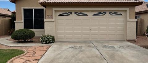
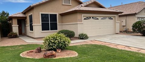
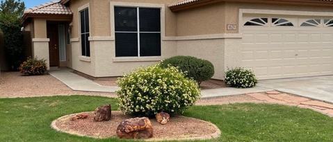
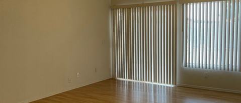
8629 W Laurel Ln
Peoria, AZ 85345
2 Weeks Ago
Favorites
-
Bedrooms
3
-
Bathrooms
2
-
Square Feet
1,284 sq ft
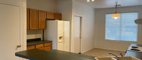
8629 W Laurel Ln

Favorites
About This Home
---- SCHEDULE A SHOWING ONLINE AT: ----
8629 W Laurel Ln is a condo located in Maricopa County and the 85345 ZIP Code.
* Price shown is base rent and may not include non-optional fees and utilities.
Price, availability, fees, and any applicable rent special are subject to change without notice.
* Square footage definitions vary. Displayed square footage is approximate.
Contact
- Listed by Locayt
Location
Get Directions
Extending south from West Peoria Avenue to West Northern Avenue, South Peoria provides easy access to Highway 101, Peoria Town Center, Sun City, Arizona State University West Campus, and Glendale Community College. Once named one of the best places to live in the US, Peoria offers a vibrant downtown with plenty to see and do. Catch a live performance at the Center for the Performing Arts or Theater Works, cheer on local sports teams at the Peoria Sports Complex, and enjoy exploring the shops along Bell Road.
Taking full advantage of the sunshine, desert landscape, and palm trees, South Peoria’s parks provide a range of outdoor activities for residents to enjoy. Thunderbird Park provides trails for walking and biking along the canal, a playground, disc golf course, and more. Those with pets will appreciate Sunnyslope Dog Park, located at the corner of West Olive Avenue and North 71st Avenue.
Learn more about living in South Peoria
Education
| Colleges & Universities | Distance | ||
|---|---|---|---|
| Colleges & Universities | Distance | ||
| Drive: | 11 min | 4.9 mi | |
| Drive: | 13 min | 5.5 mi | |
| Drive: | 13 min | 6.2 mi | |
| Drive: | 14 min | 9.0 mi |
8629 W Laurel Ln is within 11 minutes or 4.9 miles from Glendale Community College. It is also near Thunderbird, West Campus and Arizona State University, West.
Transportation options available in Peoria include Metro Pkwy, located 8.8 miles from 8629 W Laurel Ln. 8629 W Laurel Ln is near Phoenix Sky Harbor International, located 20.6 miles or 36 minutes away.
| Transit / Subway | Distance | ||
|---|---|---|---|
| Transit / Subway | Distance | ||
|
|
Drive: | 17 min | 8.8 mi |
|
|
Drive: | 19 min | 9.4 mi |
|
|
Drive: | 19 min | 10.2 mi |
|
|
Drive: | 21 min | 10.6 mi |
|
|
Drive: | 20 min | 10.7 mi |
| Airports | Distance | ||
|---|---|---|---|
| Airports | Distance | ||
|
Phoenix Sky Harbor International
|
Drive: | 36 min | 20.6 mi |
Time and distance from 8629 W Laurel Ln.
| Shopping Centers | Distance | ||
|---|---|---|---|
| Shopping Centers | Distance | ||
| Walk: | 10 min | 0.5 mi | |
| Walk: | 19 min | 1.0 mi | |
| Drive: | 4 min | 2.0 mi |
8629 W Laurel Ln has 3 shopping centers within 2.0 miles, which is about a 4-minute walk. The miles and minutes will be for the farthest away property.
| Parks and Recreation | Distance | ||
|---|---|---|---|
| Parks and Recreation | Distance | ||
|
Challenger Space Center
|
Drive: | 11 min | 7.1 mi |
|
Acoma Park
|
Drive: | 15 min | 7.7 mi |
|
El Oso Park
|
Drive: | 17 min | 8.3 mi |
|
Maryvale Park
|
Drive: | 18 min | 9.4 mi |
|
Conocido Park
|
Drive: | 18 min | 10.7 mi |
8629 W Laurel Ln has 5 parks within 10.7 miles, including Challenger Space Center, Acoma Park, and El Oso Park.
| Hospitals | Distance | ||
|---|---|---|---|
| Hospitals | Distance | ||
| Drive: | 7 min | 3.2 mi | |
| Drive: | 9 min | 4.4 mi | |
| Drive: | 10 min | 5.0 mi |
8629 W Laurel Ln has 3 hospitals within 5.0 miles, the nearest is Banner Boswell Medical Center which is 3.2 miles away and a 7 minute drive.
| Military Bases | Distance | ||
|---|---|---|---|
| Military Bases | Distance | ||
| Drive: | 16 min | 10.0 mi | |
| Drive: | 36 min | 20.5 mi | |
| Drive: | 97 min | 73.0 mi |
8629 W Laurel Ln has 3 military bases within 73.0 miles, the nearest is Luke Air Force Base which is 10.0 miles away and a 16 minute drive.
You May Also Like
Similar Rentals Nearby
-
-

-

-
 $1,7003 Beds, 2 Baths, 1,210 sq ftApartment for Rent
 -

-

-

-

-

-

What Are Walk Score®, Transit Score®, and Bike Score® Ratings?
Walk Score® measures the walkability of any address. Transit Score® measures access to public transit. Bike Score® measures the bikeability of any address.
What is a Sound Score Rating?
A Sound Score Rating aggregates noise caused by vehicle traffic, airplane traffic and local sources

8629 W Laurel Ln
Peoria, AZ 85345