$1,450 / Month

298 Burrell Ct

,

Los Gatos, CA 95033

Share Listing
Favorites
298 Burrell Ct
Share Listing
Favorites

Check Back Soon for Upcoming Availability

Beds Baths Average SF
1 Bedroom 1 Bedroom 1 Br 1 Bath 1 Bath 1 Ba 420 SF

Fees and Policies

The fees listed below are community-provided and may exclude utilities or add-ons. All payments are made directly to the property and are non-refundable unless otherwise specified.

Details

Utilities Included

  • Gas
  • Water
  • Electricity
  • Sewer

About This Property

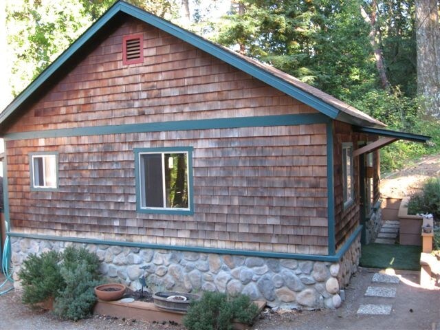
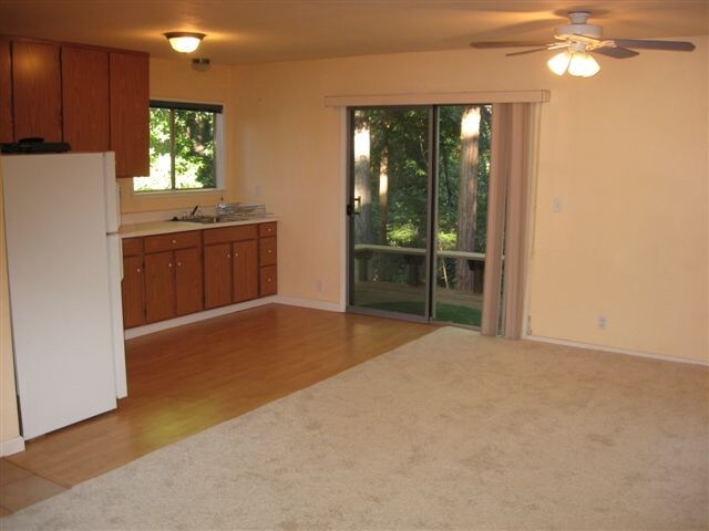
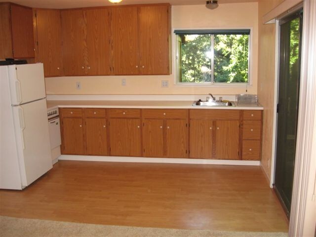
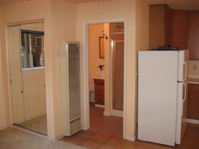
Property Id: 1456358 - Available May 15th - The cottage is located in the Summit Road area in the hills above Los Gatos Ca. This is a seperate studio cottage on our property. It's 1 mile from The Summit Market, & 12 miles (15 mins) to downtown Los Gatos. It has a full kitchen & bath, plus it's own private deck in a beautiful setting with forest & Mountain views. The rent includes utilities, plus use of the laundry facilities. Tenant is responsible for their own internet, phone, & garbage. We're looking for just 1 person to rent as we're on septic & well systems & don't want to stress those out. Also, we prefer no pets as their is no fenced yard.

298 Burrell Ct is a house located in Santa Cruz County and the 95033 ZIP Code. This area is served by the Loma Prieta Joint Union Elementary School District attendance zone.

House Features

Washer/Dryer

Refrigerator

Tile Floors

Oven

  • Washer/Dryer
  • Oven
  • Refrigerator
  • Tile Floors
  • Pool
Location
298 Burrell Ct, Los Gatos,
CA 95033
Get Directions
| Edit

Under 30 minutes

Commute Time is calculated at rush hour.
City - Los Gatos

Tucked into the foothills of the Santa Cruz Mountains, Los Gatos feels like a small town at the heart of Silicon Valley. Santa Cruz Avenue serves as the town’s social spine, lined with bars, restaurants, and independent boutiques. Outdoor escapes abound with Vasona Lake County Park, Lexington Reservoir, and Heintz Open Space offering trails minutes from home. The Montalvo Arts Center brings world-class performances to the hills above town, while the Kotani-En Japanese Garden offers quieter retreats.

Renters find thoughtful options from garden-style apartments nestled in the foothills to sleek townhomes near downtown. Studios and two-bedroom layouts appeal to those wanting walkable access to shops and dining while maintaining neighborhood calm. Netflix has been headquartered here since 2000, and the town’s name comes from a 19th-century Spanish land grant called La Rinconada de Los Gatos, named for the mountain lions and bobcats that once roamed these hills.

Learn more about living in Los Gatos 
Amenities
  • Washer/Dryer
  • Oven
  • Refrigerator
  • Tile Floors
  • Pool
Expenses
Utilities Included
Gas, Water, Electricity, Sewer Included
Education
Colleges & Universities Distance
Drive: 27 min 14.2 mi
Drive: 30 min 16.1 mi
Drive: 32 min 19.1 mi
Drive: 40 min 22.7 mi
298 Burrell Ct is within 27 minutes or 14.2 miles from Cabrillo College. It is also near West Valley College and UC Santa Cruz.
Schools
Public Elementary School
Grades K-5
500 Students
Nearby
Public Elementary School
Grades K-5
259 Students
Attendance Zone
Public Middle School
Grades 6-8
164 Students
Attendance Zone
Public High School
Grades 9-12
1,914 Students
Attendance Zone
Private Elementary, Middle & High School
Grades PK-12
Nearby
Private Elementary & Middle School
Grades PK-8
448 Students
Nearby
Private Middle & High School
Grades 6-12
1,500 Students
Nearby
Transportation

298 Burrell Ct is near Norman Y Mineta San Jose International, located 23.1 miles or 36 minutes away.

Commuter Rail Distance
Drive: 34 min 21.1 mi
Drive: 36 min 21.9 mi
Drive: 38 min 23.5 mi
Drive: 37 min 23.6 mi
Drive: 52 min 35.7 mi
Airports Distance
Airports Distance
Norman Y Mineta San Jose International
Drive: 36 min 23.1 mi

Walkability Near 298 Burrell Ct Los Gatos, CA 95033

Getting Around
Not Walkable
Walkability
10 / 100
Exceptionally Drivable
Drivability
90 / 100
Somewhat Bikeable
Bikeability
20 / 100

Scores provided by

What do Walkability, Transit, Drivability, and Bikeability mean? Walkability measures the walking distance to day-to-day needs. Transit measures access to public transportation. Drivability measures congestion, parking availability, and access to major roads. Bikeability measures the suitability for cycling. How It Works
-
Soundscore
- / 100

Traffic

-

Airport

-

Businesses

-

Scores provided by

HowLoud What is a Sound Score Rating? A Sound Score Rating aggregates noise caused by vehicle traffic, airplane traffic and local sources. How It Works
Points of Interest

Time and distance from 298 Burrell Ct.

Shopping Centers Distance
Drive: 22 min 12.4 mi
Drive: 25 min 14.0 mi
Drive: 26 min 14.3 mi
298 Burrell Ct has 3 shopping centers within 14.3 miles, which is about a 26-minute drive. The miles and minutes will be for the farthest away property.
Parks and Recreation Distance
Bear Creek Redwoods Preserve
Drive: 20 min 9.8 mi
Lexington Reservoir County Park
Drive: 21 min 11.2 mi
St. Joseph's Hill Open Space Preserve
Drive: 29 min 13.2 mi
Almaden Quicksilver County Park
Drive: 39 min 21.4 mi
Sierra Azul Open Space Preserve
Drive: 76 min 24.8 mi
298 Burrell Ct has 5 parks within 24.8 miles, including Bear Creek Redwoods Preserve, St. Joseph's Hill Open Space Preserve, and Lexington Reservoir County Park.
Hospitals Distance
Hospitals Distance
Drive: 26 min 13.4 mi
Drive: 26 min 14.2 mi
Drive: 28 min 14.8 mi
298 Burrell Ct has 3 hospitals within 14.8 miles, the nearest is Sutter Maternity & Surgery Center of Santa Cruz which is 13.4 miles away and a 26 minute drive.
Military Bases Distance
Drive: 46 min 29.1 mi
Drive: 73 min 51.3 mi
Drive: 79 min 53.6 mi
298 Burrell Ct has 3 military bases within 53.6 miles, the nearest is Ames Research Center which is 29.1 miles away and a 46 minute drive.

You May Also Like

Similar Rentals Nearby