


$3,700
/ Month
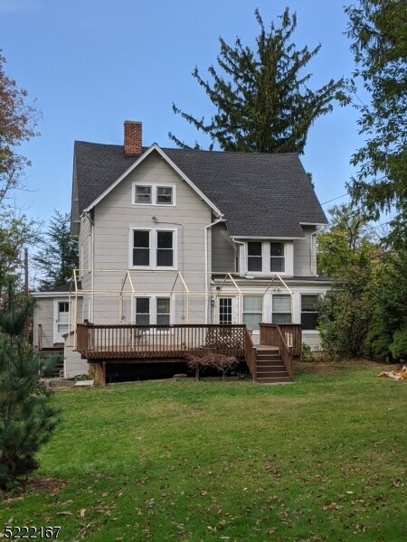
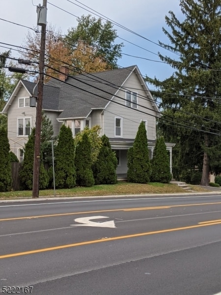
294 Pompton Ave
Cedar Grove, NJ 07009
Favorites
-
Bedrooms
3
-
Bathrooms
1
-
Square Feet
1,973 sq ft
294 Pompton Ave

Favorites
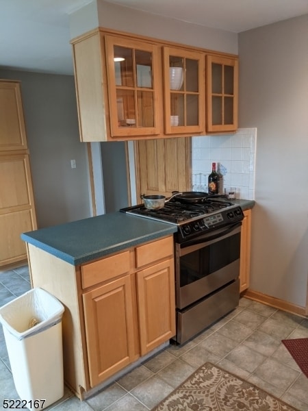
About This Home
---- SCHEDULE A SHOWING ONLINE AT: ----
294 Pompton Ave is a condo located in Essex County and the 07009 ZIP Code.
* Price shown is base rent. Excludes user-selected optional fees and variable or usage-based fees and required charges due at or prior to move-in or at move-out. Price, availability, fees, and any applicable rent special are subject to change without notice.
* Square footage definitions vary. Displayed square footage is approximate.
Contact
- Listed by Locayt
Location
Get Directions
Located about 20 miles northwest of New York City, Cedar Grove provides residents with a tranquil small-town atmosphere in Essex County. Pompton Avenue is Cedar Grove’s main commercial thoroughfare, where a bevy of quaint shops and diverse restaurants sit along a tree-lined street.
Several parks offer plenty of options for outdoor recreation in Cedar Grove, including the expansive Mills Reservation County Park, Hilltop Reservation, and Cedar Grove Community Park. Cedar Grove is also within minutes of Verona Park, Eagle Rock Reservation, and Brookdale Park. Quick access to numerous NJ Transit rail stations and major highways affords residents easy commutes and travels from Cedar Grove.
Learn more about living in Cedar Grove
Education
| Colleges & Universities | Distance | ||
|---|---|---|---|
| Colleges & Universities | Distance | ||
| Drive: | 7 min | 2.8 mi | |
| Drive: | 7 min | 3.8 mi | |
| Drive: | 7 min | 4.2 mi | |
| Drive: | 12 min | 6.6 mi |
294 Pompton Ave is within 7 minutes or 2.8 miles from Montclair State University. It is also near Caldwell College and Bloomfield College.
Transportation options available in Cedar Grove include Grove Street, located 5.3 miles from 294 Pompton Ave. 294 Pompton Ave is near Newark Liberty International, located 13.9 miles or 23 minutes away, and LaGuardia, located 30.8 miles or 45 minutes away.
| Transit / Subway | Distance | ||
|---|---|---|---|
| Transit / Subway | Distance | ||
|
|
Drive: | 9 min | 5.3 mi |
|
|
Drive: | 11 min | 5.8 mi |
|
|
Drive: | 11 min | 5.9 mi |
|
|
Drive: | 11 min | 6.0 mi |
|
|
Drive: | 10 min | 6.3 mi |
| Commuter Rail | Distance | ||
|---|---|---|---|
| Commuter Rail | Distance | ||
|
|
Drive: | 4 min | 1.6 mi |
|
|
Drive: | 5 min | 1.9 mi |
|
|
Drive: | 5 min | 2.3 mi |
|
|
Drive: | 6 min | 2.6 mi |
|
|
Drive: | 6 min | 3.0 mi |
| Airports | Distance | ||
|---|---|---|---|
| Airports | Distance | ||
|
Newark Liberty International
|
Drive: | 23 min | 13.9 mi |
|
LaGuardia
|
Drive: | 45 min | 30.8 mi |
Getting Around
 What do Walkability, Transit, Drivability, and Bikeability mean?
Walkability measures the walking distance to day-to-day needs.
Transit measures access to public transportation.
Drivability measures congestion, parking availability, and access to major roads.
Bikeability measures the suitability for cycling.
How It Works
What do Walkability, Transit, Drivability, and Bikeability mean?
Walkability measures the walking distance to day-to-day needs.
Transit measures access to public transportation.
Drivability measures congestion, parking availability, and access to major roads.
Bikeability measures the suitability for cycling.
How It Works
Fairly Walkable
Walkability
50
/ 100
Some Public Transit
Transit
40
/ 100
Exceptionally Drivable
Drivability
100
/ 100
Moderately Bikeable
Bikeability
60
/ 100
Scores provided by
-
Soundscore™
-
/ 100
Traffic
-Airport
-Businesses
-Scores provided by
HowLoud What is a Sound Score Rating? A Sound Score Rating aggregates noise caused by vehicle traffic, airplane traffic and local sources. How It WorksTime and distance from 294 Pompton Ave.
| Shopping Centers | Distance | ||
|---|---|---|---|
| Shopping Centers | Distance | ||
| Walk: | 5 min | 0.3 mi | |
| Walk: | 8 min | 0.4 mi | |
| Walk: | 12 min | 0.6 mi |
294 Pompton Ave has 3 shopping centers within 0.6 mile, which is about a 12-minute walk. The miles and minutes will be for the farthest away property.
| Parks and Recreation | Distance | ||
|---|---|---|---|
| Parks and Recreation | Distance | ||
|
Presby Memorial Iris Gardens
|
Drive: | 4 min | 1.8 mi |
|
Van Vleck House & Gardens
|
Drive: | 3 min | 2.0 mi |
|
Edison National Historic Site
|
Drive: | 11 min | 5.8 mi |
|
NJ Audubon Essex County Environmental Center
|
Drive: | 13 min | 7.9 mi |
|
Fairfield Farm
|
Drive: | 14 min | 8.3 mi |
294 Pompton Ave has 5 parks within 8.3 miles, including Presby Memorial Iris Gardens, Van Vleck House & Gardens, and Edison National Historic Site.
| Hospitals | Distance | ||
|---|---|---|---|
| Hospitals | Distance | ||
| Walk: | 15 min | 0.8 mi | |
| Drive: | 11 min | 6.0 mi | |
| Drive: | 13 min | 7.6 mi |
294 Pompton Ave has 3 hospitals within 7.6 miles, the nearest is Essex County Hospital Center which is 0.8 mile away and a 15 minute walk.
| Military Bases | Distance | ||
|---|---|---|---|
| Military Bases | Distance | ||
| Drive: | 28 min | 17.8 mi | |
| Drive: | 35 min | 20.5 mi | |
| Drive: | 36 min | 23.4 mi |
294 Pompton Ave has 3 military bases within 23.4 miles, the nearest is Military Ocean Terminal which is 17.8 miles away and a 28 minute drive.
You May Also Like
How do I access Social Services in New Jersey?
Statewide service is free, confidential, multilingual and always open. Three easy ways to reach Social Services in NJ: Dial 2-1-1; text your zip code to 898-211; or chat at https://www.nj211.org
Similar Rentals Nearby


What Are Walk Score®, Transit Score®, and Bike Score® Ratings?
Walk Score® measures the walkability of any address. Transit Score® measures access to public transit. Bike Score® measures the bikeability of any address.
What is a Sound Score Rating?
A Sound Score Rating aggregates noise caused by vehicle traffic, airplane traffic and local sources.
294 Pompton Ave
Cedar Grove, NJ 07009