
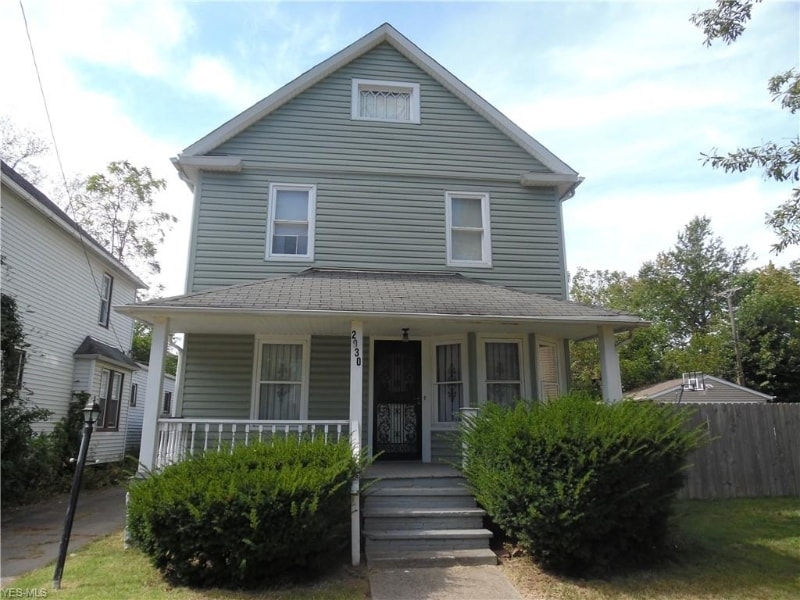

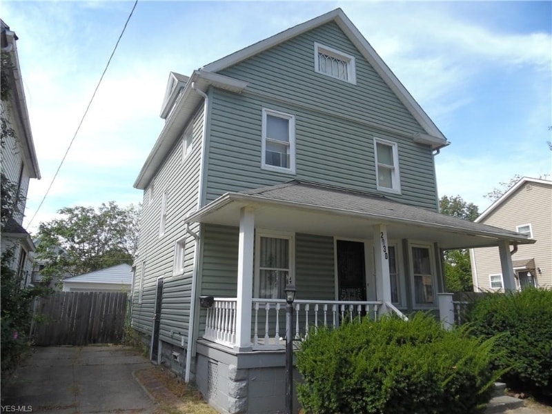
2930 E 121st St
Cleveland, OH 44120
-
Bedrooms
4
-
Bathrooms
1
-
Square Feet
3,484 sq ft
-
Available
Available Jan 1, 2026
Highlights
- Hardwood Floors
- Fenced Lot

About This Home
Property Id: 263177 A beautiful 4 bedroom, 1 bathroom Single-family home in L H Wain Rice Heights community With 3,484 Sq. Ft lot size. You will fall in love the minute you walk in the door. -A fully equipped kitchen for the cook to enjoy. - A living room/dining room combination as well as a balcony to relax. - On the first level, living room attached to the family room. Proceed through to the large dining room, with the kitchen attached. -Dual stairway to upstairs 3 bedrooms and bath. -Vinyl siding, updated windows, glass block windows, fenced yard and newer two (2) car garage. -Tenant is also responsible for utilities, cable/internet. The community does offer a playscape area as well as close to shopping, restaurants, entertainment, recreation and much more Small dogs considered on a case by case basis HOC/Section 8/ EDEN applicants are also accepted! Call to schedule your personal tour @ (301) -213 4795!!!
2930 E 121st St is a house located in Cuyahoga County and the 44120 ZIP Code. This area is served by the Cleveland Metropolitan attendance zone.
Fees and Policies
The fees below are based on community-supplied data and may exclude additional fees and utilities.
-
One-Time Basics
-
Due at Move-In
-
Security Deposit - RefundableCharged per unit.$1,499
-
-
Due at Move-In
-
Garage Lot
Property Fee Disclaimer: Based on community-supplied data and independent market research. Subject to change without notice. May exclude fees for mandatory or optional services and usage-based utilities.
House Features
Washer/Dryer
Dishwasher
Hardwood Floors
Refrigerator
- Washer/Dryer
- Dishwasher
- Oven
- Refrigerator
- Freezer
- Hardwood Floors
- Tile Floors
- Fenced Lot
Contact
- Phone Number
- Contact
-
Source

- Washer/Dryer
- Dishwasher
- Oven
- Refrigerator
- Freezer
- Hardwood Floors
- Tile Floors
- Fenced Lot
Known as one of Cleveland, Ohio's, premiere shopping and dining districts, the Buckeye-Shaker neighborhood sits on the east side of the city and contains the old Buckeye, Larchmere, and Shaker Square areas. Originally known as Little Hungary, the area of Cleveland in and around Buckeye Road contains many older single-family homes and apartment buildings. The Larchmere and Shaker Square sections of the neighborhood hold a large selection of shops and restaurants, all within easy walking distance of one another.
Bordered by University Circle to the north, Shaker Heights to the east, Mount Pleasant to the south, and Woodland Hills to the west, the Buckeye-Shaker area lies roughly six miles to the east of downtown Cleveland. Getting from the Buckeye-Shaker area to downtown is made easier thanks to the rapid transit station located near the Shaker Square shopping district.
Learn more about living in Buckeye-Shaker| Colleges & Universities | Distance | ||
|---|---|---|---|
| Colleges & Universities | Distance | ||
| Drive: | 6 min | 2.6 mi | |
| Drive: | 7 min | 2.6 mi | |
| Drive: | 7 min | 2.9 mi | |
| Drive: | 13 min | 5.0 mi |


View GreatSchools Rating Methodology
Data provided by GreatSchools.org © 2025. All rights reserved.
Transportation options available in Cleveland include East 116, located 0.7 mile from 2930 E 121st St. 2930 E 121st St is near Cleveland-Hopkins International, located 16.8 miles or 30 minutes away.
| Transit / Subway | Distance | ||
|---|---|---|---|
| Transit / Subway | Distance | ||
|
|
Walk: | 13 min | 0.7 mi |
|
|
Walk: | 14 min | 0.7 mi |
|
|
Walk: | 15 min | 0.8 mi |
|
|
Walk: | 15 min | 0.8 mi |
|
|
Walk: | 21 min | 1.1 mi |
| Commuter Rail | Distance | ||
|---|---|---|---|
| Commuter Rail | Distance | ||
|
|
Drive: | 19 min | 7.6 mi |
| Drive: | 19 min | 7.8 mi | |
| Drive: | 22 min | 9.5 mi | |
| Drive: | 31 min | 18.4 mi | |
|
Boston Mill
|
Drive: | 37 min | 22.8 mi |
| Airports | Distance | ||
|---|---|---|---|
| Airports | Distance | ||
|
Cleveland-Hopkins International
|
Drive: | 30 min | 16.8 mi |
Time and distance from 2930 E 121st St.
| Shopping Centers | Distance | ||
|---|---|---|---|
| Shopping Centers | Distance | ||
| Walk: | 11 min | 0.6 mi | |
| Walk: | 12 min | 0.6 mi | |
| Walk: | 14 min | 0.8 mi |
| Parks and Recreation | Distance | ||
|---|---|---|---|
| Parks and Recreation | Distance | ||
|
Nature Center at Shaker Lakes
|
Drive: | 5 min | 1.9 mi |
|
Children's Museum of Cleveland
|
Drive: | 5 min | 2.3 mi |
|
Cleveland Botanical Garden
|
Drive: | 6 min | 2.7 mi |
|
Cleveland Museum of Natural History
|
Drive: | 7 min | 2.9 mi |
|
Garfield Park Nature Center
|
Drive: | 10 min | 4.9 mi |
| Hospitals | Distance | ||
|---|---|---|---|
| Hospitals | Distance | ||
| Walk: | 15 min | 0.8 mi | |
| Drive: | 6 min | 2.5 mi | |
| Drive: | 6 min | 2.5 mi |
| Military Bases | Distance | ||
|---|---|---|---|
| Military Bases | Distance | ||
| Drive: | 105 min | 85.5 mi | |
| Drive: | 107 min | 86.8 mi |
2930 E 121st St Photos
Nearby Apartments
Within 50 Miles of 2930 E 121st St Cleveland, OH 44120
-
9418 Easton Ave
Cleveland, OH 44104
$1,400
4 Br 1.3 mi
-
5 bd, 2 ba, 1,548 Sq. Ft.
3060 Charles Carr Pl
Cleveland, OH 44104
$1,500
5 Br 2.0 mi
-
1222 Castleton Rd
Cleveland Heights, OH 44121
$3,000
4 Br 4.0 mi
-
17100 Maple Heights Blvd
Maple hts, OH 44135
$2,500
5 Br 4.9 mi
-
888 Evangeline Rd
Cleveland, OH 44110
$1,695
5 Br 5.4 mi
-
775 Shelley Pkwy
Berea, OH 44017
$1,850
4 Br 14.8 mi
What Are Walk Score®, Transit Score®, and Bike Score® Ratings?
Walk Score® measures the walkability of any address. Transit Score® measures access to public transit. Bike Score® measures the bikeability of any address.
What is a Sound Score Rating?
A Sound Score Rating aggregates noise caused by vehicle traffic, airplane traffic and local sources
2930 E 121st St
Cleveland, OH 44120