


$995
/ Month
2885 Ludlow Rd
Cleveland, OH 44120
2 Weeks Ago
Favorites
2885 Ludlow Rd

Favorites
Check Back Soon for Upcoming Availability
| Beds | Baths | Average SF |
|---|---|---|
| 3 Bedrooms 3 Bedrooms 3 Br | 1 Bath 1 Bath 1 Ba | — |
About This Property
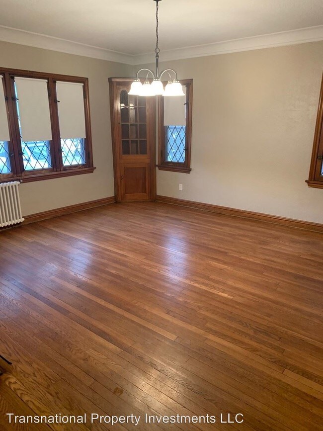
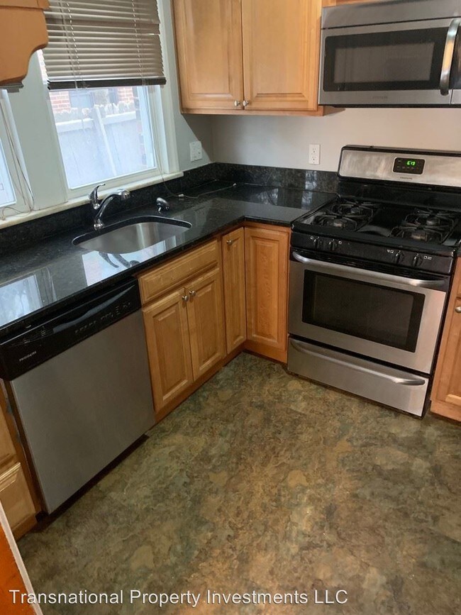
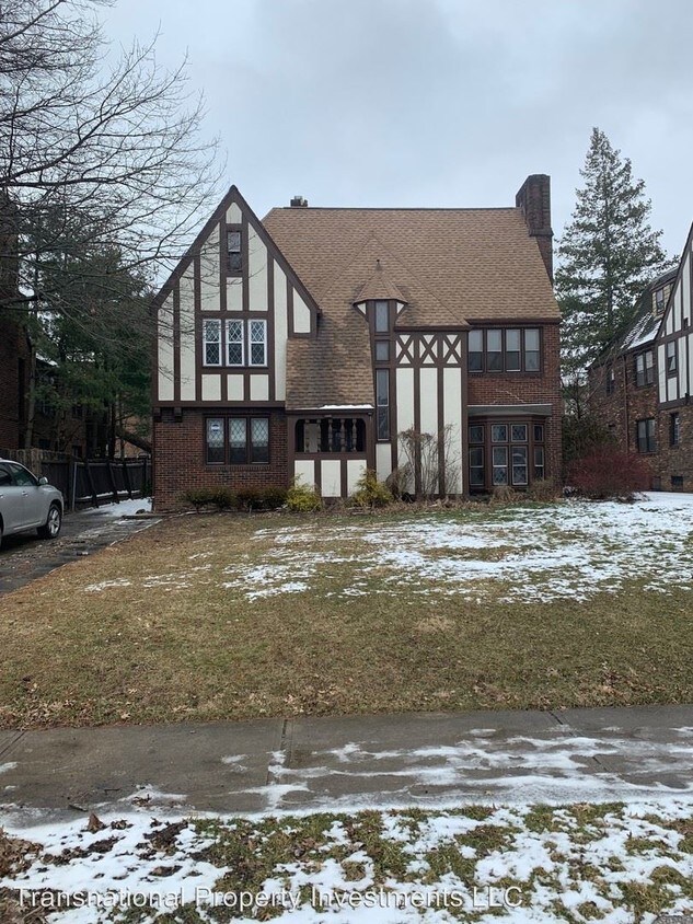
(216) 242-1400 - Gorgeous 3 Bedroom Home Located in Shaker Heights Available! - Transnational is offering a beautiful 3 bedroom 1 full bathroom home located in the desirable Shaker Heights school district. This is the lower level of a two-family house that has been renovated top to bottom while still maintaining the old-world charm one would expect in an all brick Van Sweringen home. Enter the front door in to a cozy foyer with access to up and down units. This unit have the original wood floors throughout,a remodeled kitchen that comes equipped with stainless steel appliances, a granite counter-top, ceramic floors and new cabinetry (2016). The bathroom has beautiful ceramic tile flooring and wall surroundings. This historic home has captured the natural feel with it's classic archways, built in fireplace and timeless multi-panel windows.Updated light fixtures throughout and ceiling fans in each bedroom. Home has boiler system,New garage with 1 car garage space and remote opener. Conveniently located near shaker square that host many restaurants, boutiques, shops and more. (RLNE4722933)
2885 Ludlow Rd is an apartment community located in Cuyahoga County and the 44120 ZIP Code.
Location
Get Directions
Known as one of Cleveland, Ohio's, premiere shopping and dining districts, the Buckeye-Shaker neighborhood sits on the east side of the city and contains the old Buckeye, Larchmere, and Shaker Square areas. Originally known as Little Hungary, the area of Cleveland in and around Buckeye Road contains many older single-family homes and apartment buildings. The Larchmere and Shaker Square sections of the neighborhood hold a large selection of shops and restaurants, all within easy walking distance of one another.
Bordered by University Circle to the north, Shaker Heights to the east, Mount Pleasant to the south, and Woodland Hills to the west, the Buckeye-Shaker area lies roughly six miles to the east of downtown Cleveland. Getting from the Buckeye-Shaker area to downtown is made easier thanks to the rapid transit station located near the Shaker Square shopping district.
Learn more about living in Buckeye-ShakerBelow are rent ranges for similar nearby apartments
| Beds | Average Size | Lowest | Typical | Premium |
|---|---|---|---|---|
| Studio Studio Studio | 427 Sq Ft | $700 | $1,145 | $1,650 |
| 1 Bed 1 Bed 1 Bed | 619-623 Sq Ft | $700 | $1,010 | $2,535 |
| 2 Beds 2 Beds 2 Beds | 1013-1014 Sq Ft | $600 | $1,244 | $2,595 |
| 3 Beds 3 Beds 3 Beds | 1395 Sq Ft | $850 | $1,633 | $2,500 |
| 4 Beds 4 Beds 4 Beds | 1804 Sq Ft | $1,300 | $1,375 | $1,450 |
Education
| Colleges & Universities | Distance | ||
|---|---|---|---|
| Colleges & Universities | Distance | ||
| Drive: | 7 min | 3.0 mi | |
| Drive: | 8 min | 3.0 mi | |
| Drive: | 8 min | 3.3 mi | |
| Drive: | 11 min | 4.4 mi |
2885 Ludlow Rd is within 7 minutes or 3.0 miles from Case Western Reserve. It is also near Cleveland Institute of Art and Cleveland Institute of Music.
Transportation options available in Cleveland include South Woodland, located 0.2 mile from 2885 Ludlow Rd. 2885 Ludlow Rd is near Cleveland-Hopkins International, located 17.4 miles or 31 minutes away.
| Transit / Subway | Distance | ||
|---|---|---|---|
| Transit / Subway | Distance | ||
|
|
Walk: | 4 min | 0.2 mi |
|
|
Walk: | 5 min | 0.3 mi |
|
|
Walk: | 6 min | 0.4 mi |
|
|
Walk: | 9 min | 0.5 mi |
|
|
Walk: | 11 min | 0.6 mi |
| Commuter Rail | Distance | ||
|---|---|---|---|
| Commuter Rail | Distance | ||
|
|
Drive: | 20 min | 8.3 mi |
| Drive: | 20 min | 8.5 mi | |
| Drive: | 23 min | 10.2 mi | |
| Drive: | 33 min | 19.1 mi | |
|
Boston Mill
|
Drive: | 35 min | 22.2 mi |
| Airports | Distance | ||
|---|---|---|---|
| Airports | Distance | ||
|
Cleveland-Hopkins International
|
Drive: | 31 min | 17.4 mi |
Time and distance from 2885 Ludlow Rd.
| Shopping Centers | Distance | ||
|---|---|---|---|
| Shopping Centers | Distance | ||
| Walk: | 5 min | 0.3 mi | |
| Walk: | 7 min | 0.4 mi | |
| Drive: | 4 min | 1.2 mi |
2885 Ludlow Rd has 3 shopping centers within 1.2 miles, which is about a 4-minute walk. The miles and minutes will be for the farthest away property.
| Parks and Recreation | Distance | ||
|---|---|---|---|
| Parks and Recreation | Distance | ||
|
Nature Center at Shaker Lakes
|
Drive: | 3 min | 1.3 mi |
|
Children's Museum of Cleveland
|
Drive: | 6 min | 2.7 mi |
|
Cleveland Botanical Garden
|
Drive: | 7 min | 3.1 mi |
|
Cleveland Museum of Natural History
|
Drive: | 8 min | 3.4 mi |
|
Garfield Park Nature Center
|
Drive: | 11 min | 5.6 mi |
2885 Ludlow Rd has 5 parks within 5.6 miles, including Nature Center at Shaker Lakes, Children's Museum of Cleveland, and Cleveland Botanical Garden.
| Hospitals | Distance | ||
|---|---|---|---|
| Hospitals | Distance | ||
| Drive: | 4 min | 1.5 mi | |
| Drive: | 7 min | 2.9 mi | |
| Drive: | 7 min | 2.9 mi |
2885 Ludlow Rd has 3 hospitals within 2.9 miles, the nearest is Cleveland Clinic Children's Hospital for Rehab which is 1.5 miles away and a 4 minute drive.
| Military Bases | Distance | ||
|---|---|---|---|
| Military Bases | Distance | ||
| Drive: | 106 min | 87.0 mi | |
| Drive: | 108 min | 87.5 mi |
2885 Ludlow Rd is 87.0 miles from Mansfield Lahm Airport Air Guard Station, and is convenient to other military bases, including Camp Perry Air Guard Station.
You May Also Like
Similar Rentals Nearby
")


What Are Walk Score®, Transit Score®, and Bike Score® Ratings?
Walk Score® measures the walkability of any address. Transit Score® measures access to public transit. Bike Score® measures the bikeability of any address.
What is a Sound Score Rating?
A Sound Score Rating aggregates noise caused by vehicle traffic, airplane traffic and local sources
2885 Ludlow Rd
Cleveland, OH 44120