$2,000
/ Month
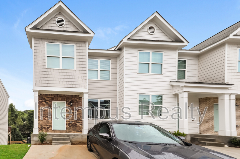
2832 Laurel Ridge Cir
East Point, GA 30344
Favorites
-
Bedrooms
3
-
Bathrooms
2.5
-
Square Feet
1,392 sq ft
2832 Laurel Ridge Cir

Favorites
About This Home
$2,000 deposit
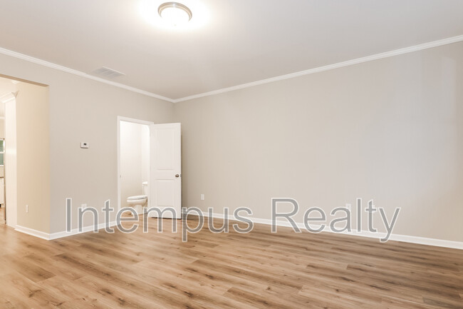
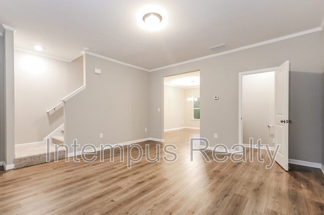
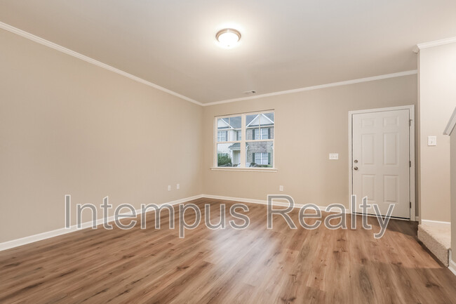
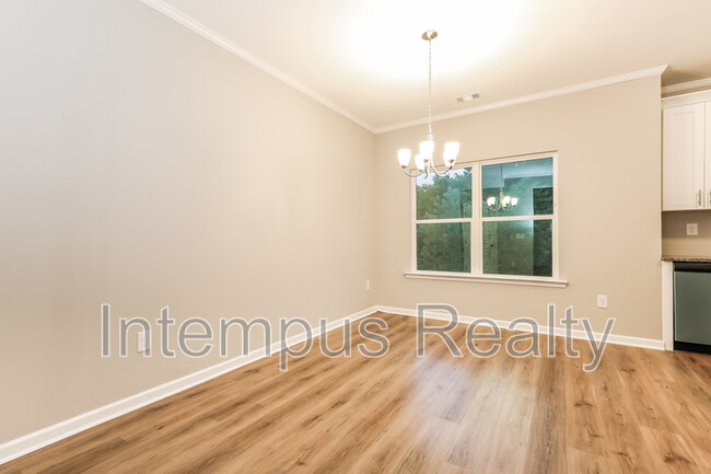
Welcome to this stunning brand-new construction townhome that offers style, comfort, and convenience! This spacious 3-bedroom, 2.5-bathroom home boasts a modern open floor plan with LVP flooring throughout the main level, making it both beautiful and easy to maintain. The chef's kitchen is a dream, featuring: ** Stainless steel appliances ** Granite countertops ** Custom kitchen island/bar perfect for meal prep or entertaining The owners suite is your private retreat, offering a large bathroom with a tub/shower combo. Two additional bedrooms share a full bathroom, providing ample space for family or guests. Need extra storage? This home includes a full, clean unfinished basement a rare find! Prime Location: ** 5 minutes to Camp Creek Marketplace, one of Atlanta's largest shopping and dining hubs ** Easy access to I-285, downtown Atlanta, and the ATL Airport Rental Details: All properties are rented as-is ** Minimum 620 credit score required ** Income must be 3x the monthly rent ** Application fee: $75 per applicant Dont miss out schedule your tour today and take advantage of this limited-time offer!
2832 Laurel Ridge Cir is a townhome located in Fulton County and the 30344 ZIP Code.
* Price shown is base rent. Excludes user-selected optional fees and variable or usage-based fees and required charges due at or prior to move-in or at move-out. Price, availability, fees, and any applicable rent special are subject to change without notice.
* Square footage definitions vary. Displayed square footage is approximate.
Townhome Features
- Dishwasher
- Refrigerator
- Patio
Fees and Policies
The fees listed below are community-provided and may exclude utilities or add-ons. All payments are made directly to the property and are non-refundable unless otherwise specified.
Contact
Location
Get Directions
Aerotropolis refers to an array of Southside Atlanta communities surrounding Hartsfield-Jackson Atlanta International Airport, the world’s busiest airport. The cities of College Park, Chattahoochee Hills, East Point, Fairburn, Forest Park, Union City, Hapeville, Morrow, and Palmetto are all a part of the Aerotropolis Alliance, working together on initiatives to improve their respective communities.
Aerotropolis’ close proximity to the airport makes the region an ideal choice for local employees and frequent travelers alike. A wide variety of rentals are available throughout the region, from luxury apartments and cozy condos to charming townhomes and spacious houses. Getting around from Aerotropolis is easy with access to I-75, I-85, and I-285.
Learn more about living in Aerotropolis
Amenities
- Dishwasher
- Refrigerator
- Patio
Education
| Colleges & Universities | Distance | ||
|---|---|---|---|
| Colleges & Universities | Distance | ||
| Drive: | 16 min | 10.1 mi | |
| Drive: | 18 min | 10.5 mi | |
| Drive: | 20 min | 10.7 mi | |
| Drive: | 20 min | 10.8 mi |
2832 Laurel Ridge Cir is within 16 minutes or 10.1 miles from Atlanta Metropolitan State. It is also near Atlanta Technical College and Morehouse School of Medicine.
Transportation options available in East Point include College Park, located 3.6 miles from 2832 Laurel Ridge Cir. 2832 Laurel Ridge Cir is near Hartsfield - Jackson Atlanta International, located 9.1 miles or 16 minutes away.
| Transit / Subway | Distance | ||
|---|---|---|---|
| Transit / Subway | Distance | ||
|
|
Drive: | 7 min | 3.6 mi |
|
|
Drive: | 8 min | 4.0 mi |
|
|
Drive: | 11 min | 5.5 mi |
|
|
Drive: | 13 min | 7.4 mi |
|
|
Drive: | 14 min | 8.2 mi |
| Commuter Rail | Distance | ||
|---|---|---|---|
| Commuter Rail | Distance | ||
|
|
Drive: | 26 min | 16.6 mi |
| Airports | Distance | ||
|---|---|---|---|
| Airports | Distance | ||
|
Hartsfield - Jackson Atlanta International
|
Drive: | 16 min | 9.1 mi |
Getting Around
 What do Walkability, Transit, Drivability, and Bikeability mean?
Walkability measures the walking distance to day-to-day needs.
Transit measures access to public transportation.
Drivability measures congestion, parking availability, and access to major roads.
Bikeability measures the suitability for cycling.
How It Works
What do Walkability, Transit, Drivability, and Bikeability mean?
Walkability measures the walking distance to day-to-day needs.
Transit measures access to public transportation.
Drivability measures congestion, parking availability, and access to major roads.
Bikeability measures the suitability for cycling.
How It Works
Fairly Walkable
Walkability
40
/ 100
Limited Public Transit
Transit
30
/ 100
Very Drivable
Drivability
80
/ 100
Somewhat Bikeable
Bikeability
30
/ 100
Scores provided by
Busy
Soundscore™
66
/ 100
Traffic
BusyAirport
BusyBusinesses
CalmScores provided by
HowLoud What is a Sound Score Rating? A Sound Score Rating aggregates noise caused by vehicle traffic, airplane traffic and local sources. How It WorksTime and distance from 2832 Laurel Ridge Cir.
| Shopping Centers | Distance | ||
|---|---|---|---|
| Shopping Centers | Distance | ||
| Walk: | 20 min | 1.1 mi | |
| Drive: | 5 min | 1.7 mi | |
| Drive: | 4 min | 1.7 mi |
2832 Laurel Ridge Cir has 3 shopping centers within 1.7 miles, which is about a 4-minute drive. The miles and minutes will be for the farthest away property.
| Parks and Recreation | Distance | ||
|---|---|---|---|
| Parks and Recreation | Distance | ||
|
Cascade Springs Nature Preserve
|
Drive: | 11 min | 7.1 mi |
|
West Atlanta Watershed Alliance (WAWA)
|
Drive: | 16 min | 8.9 mi |
|
Atlanta BeltLine Southwest Connector Spur Trail
|
Drive: | 16 min | 9.4 mi |
|
Park Pride
|
Drive: | 19 min | 11.2 mi |
|
Zoo Atlanta
|
Drive: | 21 min | 12.5 mi |
2832 Laurel Ridge Cir has 5 parks within 12.5 miles, including Cascade Springs Nature Preserve, West Atlanta Watershed Alliance (WAWA), and Atlanta BeltLine Southwest Connector Spur Trail.
| Hospitals | Distance | ||
|---|---|---|---|
| Hospitals | Distance | ||
| Drive: | 13 min | 6.6 mi | |
| Drive: | 18 min | 9.5 mi | |
| Drive: | 17 min | 10.2 mi |
2832 Laurel Ridge Cir has 3 hospitals within 10.2 miles, the nearest is Southern Crescent Behavioral Health System - Anchor Hospital Campus which is 6.6 miles away and a 13 minute drive.
| Military Bases | Distance | ||
|---|---|---|---|
| Military Bases | Distance | ||
| Drive: | 15 min | 8.0 mi | |
| Drive: | 25 min | 15.4 mi | |
| Drive: | 32 min | 21.1 mi |
2832 Laurel Ridge Cir has 3 military bases within 21.1 miles, the nearest is Fort McPherson which is 8.0 miles away and a 15 minute drive.
You May Also Like
Similar Rentals Nearby
-
-
3 Beds$2,568+Total Monthly PriceTotal Monthly Price NewPrices include base rent and required monthly fees of $108 - $111. Variable costs based on usage may apply.Base Rent:3 Beds$2,460Specials
Pets Allowed Fitness Center Walk-In Closets Stainless Steel Appliances Controlled Access Hardwood Floors EV Charging
-
-
3 Beds$2,883+Total Monthly PriceTotal Monthly Price NewPrices include base rent and required monthly fees of $83. Variable costs based on usage may apply.Base Rent:3 Beds$2,799+
Pets Allowed Fitness Center Pool Grill Business Center Hardwood Floors
-
3 Beds$2,806+Total Monthly PriceTotal Monthly Price NewPrices include base rent and required monthly fees of $125. Variable costs based on usage may apply.Base Rent:3 Beds$2,680+2 Months Free
Pets Allowed Pool In Unit Washer & Dryer Clubhouse Stainless Steel Appliances Granite Countertops Gated
-
3 Beds$2,241+Total Monthly PriceTotal Monthly Price NewPrices include required monthly fees of $143.Base Rent:3 Beds$2,097+Specials
Pets Allowed Fitness Center Pool Kitchen Walk-In Closets Clubhouse
-
3 Beds$3,138+Total Monthly PriceTotal Monthly Price NewPrices include base rent and required monthly fees of $174. Variable costs based on usage may apply.Base Rent:3 Beds$2,963+2 Months Free
Pets Allowed Fitness Center Pool Dishwasher In Unit Washer & Dryer Walk-In Closets Stainless Steel Appliances
-
3 Beds$1,589+Total Monthly PriceTotal Monthly Price NewPrices include required monthly fees of $121.Base Rent:3 Beds$1,467+Specials
Pets Allowed Fitness Center Pool Dishwasher Walk-In Closets Clubhouse
-
-


What Are Walk Score®, Transit Score®, and Bike Score® Ratings?
Walk Score® measures the walkability of any address. Transit Score® measures access to public transit. Bike Score® measures the bikeability of any address.
What is a Sound Score Rating?
A Sound Score Rating aggregates noise caused by vehicle traffic, airplane traffic and local sources.

2832 Laurel Ridge Cir
East Point, GA 30344