$1,800
/ Month
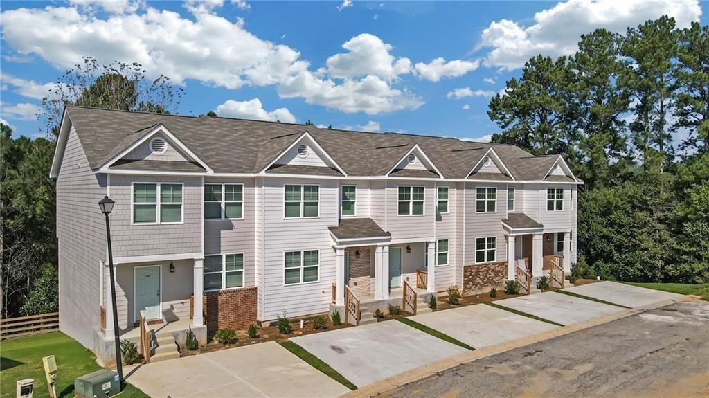
2832 Laurel Ridge Cir
East Point, GA 30344
Favorites
678-878-7590
-
Bedrooms
3
-
Bathrooms
2.5
-
Square Feet
1,492 sq ft
-
Available
Available Now
Highlights
- Open-Concept Dining Room
- Property is near public transit, schools, and shops
- Rural View
- Oversized primary bedroom
- Traditional Architecture
- Stone Countertops
2832 Laurel Ridge Cir

Favorites
About This Home
Available Now
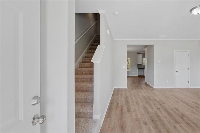
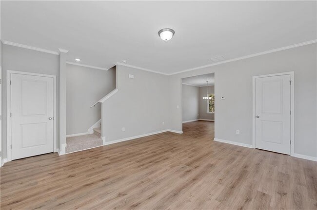
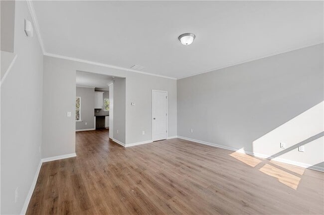
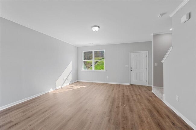
Come Check out this newer Construction Townhome! This 3 Bed/2.5 Bath New Construction Townhome features an Incredible Floor Plan w/ LVP Flooring throughout the Main Level. Spacious Custom Eat-In Kitchen w/ SS Appliances(To Be added at Move In),Granite Countertops. Oversized Master Bedroom. Large Bathroom with Tub/Shower Combo. 2 Large Supporting Bedrooms w/ Shared Full Bath. Tons of storage space w/ the FULL,CLEAN Unfinished Basement. Great Location! 5 minutes from Camp Creek Marketplace,one of the largest shopping centers in Atlanta. Minutes to I-285,Downtown Atlanta,and ATL Airport. MLS ID 7756336
2832 Laurel Ridge Cir is a townhome located in Fulton County and the 30344 ZIP Code. This area is served by the Fulton County School District attendance zone.
* Price shown is base rent. Excludes user-selected optional fees and variable or usage-based fees and required charges due at or prior to move-in or at move-out. Price, availability, fees, and any applicable rent special are subject to change without notice.
* Square footage definitions vary. Displayed square footage is approximate.
Home Details
Home Type
Townhome
Year Built
Built in 2023
Attic
Attic Fan
Bedrooms and Bathrooms
Oversized primary bedroom
Walk-In Closet
Bathtub with Shower
2.5 Bathrooms
3 Bedrooms
Low Flow Plumbing Fixtures
Flooring
Sustainable
Carpet
Vinyl
Home Design
Traditional Architecture
Shingle Roof
Brick Front
Cement Siding
Composition Roof
Home Security
Carbon Monoxide Detectors
Fire and Smoke Detector
Interior Spaces
Open-Concept Dining Room
Dining Room Seats More Than Twelve
Ceiling height of 10 feet on the main level
1,492 Sq Ft Home
Insulated Windows
Kitchen
Stone Countertops
Electric Cooktop
Eat-In Kitchen
Breakfast Bar
Electric Oven
Microwave
Dishwasher
Disposal
Laundry
Laundry Room
Laundry in Hall
Laundry on upper level
Listing and Financial Details
Security Deposit $1,800
Property Available on 5/1/26
12 Month Lease Term
Assessor Parcel Number 14 018900040620
Location
Property is near public transit, schools, and shops
Lot Details
784 Sq Ft Lot
Private Entrance
Two or More Common Walls
Property fronts a private road
Parking
On-Street Parking
Driveway Level
Parking Pad
Schools
Brookview Elementary School
Woodland - Fulton Middle School
Banneker High School
Unfinished Basement
Natural lighting in basement
Basement Fills Entire Space Under The House
Stubbed For A Bathroom
Utilities
Zoned Heating and Cooling
High Speed Internet
Heat Pump System
Cable TV Available
Phone Available
Underground Utilities
Electric Water Heater
Views
Rural Views
Community Details
Overview
Property has a Home Owners Association
Maintained Community
Pet Policy
Call for details about the types of pets allowed
Pet Deposit $300
Recreation
Park
Contact
- Listed by Andy Griffith | Engel & Volkers Atlanta
- Phone Number
- Contact
-
Source
 First Multiple Listing Service, Inc.
Copyright © 2026 First Multiple Listing Service, Inc. All rights reserved. All information provided by the listing agent/broker is deemed reliable but is not guaranteed and should be independently verified.
Location
Get Directions
Aerotropolis refers to an array of Southside Atlanta communities surrounding Hartsfield-Jackson Atlanta International Airport, the world’s busiest airport. The cities of College Park, Chattahoochee Hills, East Point, Fairburn, Forest Park, Union City, Hapeville, Morrow, and Palmetto are all a part of the Aerotropolis Alliance, working together on initiatives to improve their respective communities.
Aerotropolis’ close proximity to the airport makes the region an ideal choice for local employees and frequent travelers alike. A wide variety of rentals are available throughout the region, from luxury apartments and cozy condos to charming townhomes and spacious houses. Getting around from Aerotropolis is easy with access to I-75, I-85, and I-285.
Learn more about living in Aerotropolis
Amenities
- Dishwasher
- Disposal
- Microwave
- Oven
- Range
- Refrigerator
Education
| Colleges & Universities | Distance | ||
|---|---|---|---|
| Colleges & Universities | Distance | ||
| Drive: | 16 min | 10.1 mi | |
| Drive: | 18 min | 10.5 mi | |
| Drive: | 20 min | 10.7 mi | |
| Drive: | 20 min | 10.8 mi |
2832 Laurel Ridge Cir is within 16 minutes or 10.1 miles from Atlanta Metropolitan State. It is also near Atlanta Technical College and Morehouse School of Medicine.
Schools


Public Elementary School
Grades PK-5
420 Students
Attendance Zone
Public Middle School
Grades 6-8
922 Students
Attendance Zone
Public High School
Grades 9-12
352 Students
Nearby
Public High School
Grades 9-12
1,765 Students
Attendance Zone
Private Elementary School
Grades K-5
3 Students
Nearby
Private Elementary School
Grades PK-5
30 Students
Nearby
Private Elementary, Middle & High School
Grades PK-12
33 Students
Nearby
Private High School
Grades 9-12
7 Students
Nearby
School data provided by
 The GreatSchools Rating helps parents compare schools within a state based on a variety of school quality indicators and provides a helpful picture of how effectively each school serves all of its students. Ratings are on a scale of 1 (below average) to 10 (above average) and can include test scores, college readiness, academic progress, advanced courses, equity, discipline and attendance data. We also advise parents to visit schools, consider other information on school performance and programs, and consider family needs as part of the school selection process.
View GreatSchools Rating Methodology
Data provided by GreatSchools.org © 2026. All rights reserved.
View GreatSchools Rating Methodology
Data provided by GreatSchools.org © 2026. All rights reserved.
Transportation options available in East Point include College Park, located 3.6 miles from 2832 Laurel Ridge Cir. 2832 Laurel Ridge Cir is near Hartsfield - Jackson Atlanta International, located 9.1 miles or 16 minutes away.
| Transit / Subway | Distance | ||
|---|---|---|---|
| Transit / Subway | Distance | ||
|
|
Drive: | 7 min | 3.6 mi |
|
|
Drive: | 8 min | 4.0 mi |
|
|
Drive: | 11 min | 5.5 mi |
|
|
Drive: | 13 min | 7.4 mi |
|
|
Drive: | 14 min | 8.2 mi |
| Commuter Rail | Distance | ||
|---|---|---|---|
| Commuter Rail | Distance | ||
|
|
Drive: | 26 min | 16.6 mi |
| Airports | Distance | ||
|---|---|---|---|
| Airports | Distance | ||
|
Hartsfield - Jackson Atlanta International
|
Drive: | 16 min | 9.1 mi |
Getting Around
 What do Walkability, Transit, Drivability, and Bikeability mean?
Walkability measures the walking distance to day-to-day needs.
Transit measures access to public transportation.
Drivability measures congestion, parking availability, and access to major roads.
Bikeability measures the suitability for cycling.
How It Works
What do Walkability, Transit, Drivability, and Bikeability mean?
Walkability measures the walking distance to day-to-day needs.
Transit measures access to public transportation.
Drivability measures congestion, parking availability, and access to major roads.
Bikeability measures the suitability for cycling.
How It Works
Fairly Walkable
Walkability
40
/ 100
Limited Public Transit
Transit
30
/ 100
Very Drivable
Drivability
80
/ 100
Somewhat Bikeable
Bikeability
30
/ 100
Scores provided by
Busy
Soundscore™
66
/ 100
Traffic
BusyAirport
BusyBusinesses
CalmScores provided by
HowLoud What is a Sound Score Rating? A Sound Score Rating aggregates noise caused by vehicle traffic, airplane traffic and local sources. How It WorksTime and distance from 2832 Laurel Ridge Cir.
| Shopping Centers | Distance | ||
|---|---|---|---|
| Shopping Centers | Distance | ||
| Walk: | 20 min | 1.1 mi | |
| Drive: | 5 min | 1.7 mi | |
| Drive: | 4 min | 1.7 mi |
2832 Laurel Ridge Cir has 3 shopping centers within 1.7 miles, which is about a 4-minute drive. The miles and minutes will be for the farthest away property.
| Parks and Recreation | Distance | ||
|---|---|---|---|
| Parks and Recreation | Distance | ||
|
Cascade Springs Nature Preserve
|
Drive: | 11 min | 7.1 mi |
|
West Atlanta Watershed Alliance (WAWA)
|
Drive: | 16 min | 8.9 mi |
|
Atlanta BeltLine Southwest Connector Spur Trail
|
Drive: | 16 min | 9.4 mi |
|
Park Pride
|
Drive: | 19 min | 11.2 mi |
|
Zoo Atlanta
|
Drive: | 21 min | 12.5 mi |
2832 Laurel Ridge Cir has 5 parks within 12.5 miles, including Cascade Springs Nature Preserve, West Atlanta Watershed Alliance (WAWA), and Atlanta BeltLine Southwest Connector Spur Trail.
| Hospitals | Distance | ||
|---|---|---|---|
| Hospitals | Distance | ||
| Drive: | 13 min | 6.6 mi | |
| Drive: | 18 min | 9.5 mi | |
| Drive: | 17 min | 10.2 mi |
2832 Laurel Ridge Cir has 3 hospitals within 10.2 miles, the nearest is Southern Crescent Behavioral Health System - Anchor Hospital Campus which is 6.6 miles away and a 13 minute drive.
| Military Bases | Distance | ||
|---|---|---|---|
| Military Bases | Distance | ||
| Drive: | 15 min | 8.0 mi | |
| Drive: | 25 min | 15.4 mi | |
| Drive: | 32 min | 21.1 mi |
2832 Laurel Ridge Cir has 3 military bases within 21.1 miles, the nearest is Fort McPherson which is 8.0 miles away and a 15 minute drive.
You May Also Like
Similar Rentals Nearby
-
-
-
-
3 Beds$3,073Total Monthly PriceTotal Monthly Price NewPrices include base rent and required monthly fees of $83. Variable costs based on usage may apply.Base Rent:3 Beds$2,989+Specials
Pets Allowed Fitness Center Pool Grill Business Center Hardwood Floors
-
3 Beds$2,818+Total Monthly PriceTotal Monthly Price NewPrices include base rent and required monthly fees of $125. Variable costs based on usage may apply.Base Rent:3 Beds$2,692+2 Months Free
Pets Allowed Pool In Unit Washer & Dryer Clubhouse Stainless Steel Appliances Granite Countertops Gated
-
3 Beds$2,241+Total Monthly PriceTotal Monthly Price NewPrices include required monthly fees of $143.Base Rent:3 Beds$2,097+Specials
Pets Allowed Fitness Center Pool Kitchen Walk-In Closets Clubhouse
-
3 Beds$3,138+Total Monthly PriceTotal Monthly Price NewPrices include base rent and required monthly fees of $174. Variable costs based on usage may apply.Base Rent:3 Beds$2,963+2 Months Free
Pets Allowed Fitness Center Pool Dishwasher In Unit Washer & Dryer Walk-In Closets Stainless Steel Appliances
-
3 Beds$1,589+Total Monthly PriceTotal Monthly Price NewPrices include required monthly fees of $121.Base Rent:3 Beds$1,467+Specials
Pets Allowed Fitness Center Pool Dishwasher Walk-In Closets Clubhouse
-
-


What Are Walk Score®, Transit Score®, and Bike Score® Ratings?
Walk Score® measures the walkability of any address. Transit Score® measures access to public transit. Bike Score® measures the bikeability of any address.
What is a Sound Score Rating?
A Sound Score Rating aggregates noise caused by vehicle traffic, airplane traffic and local sources.

2832 Laurel Ridge Cir
East Point, GA 30344