
$2,500
/ Month
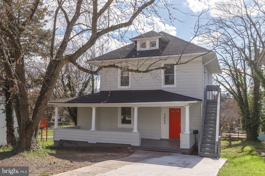
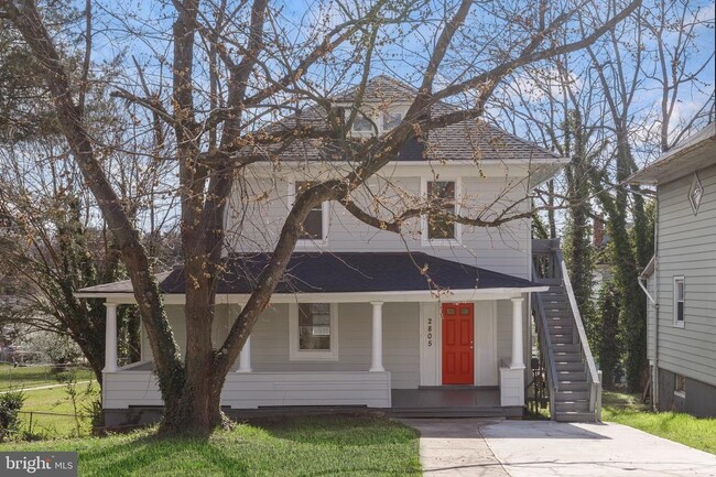
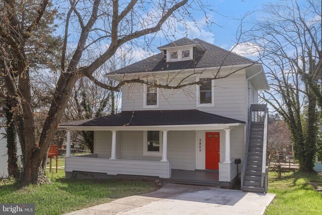
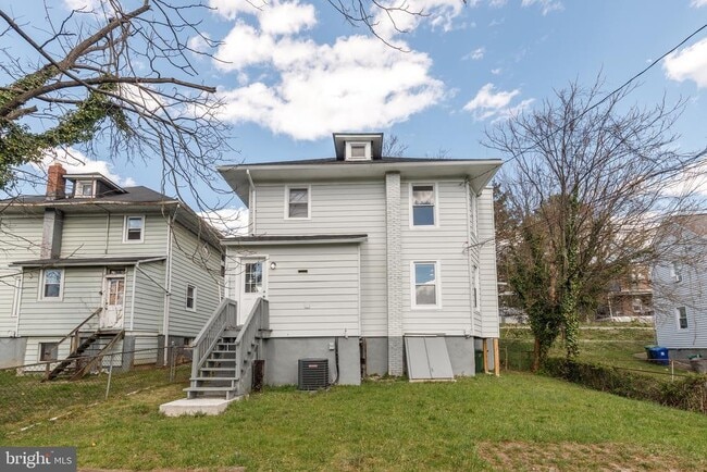
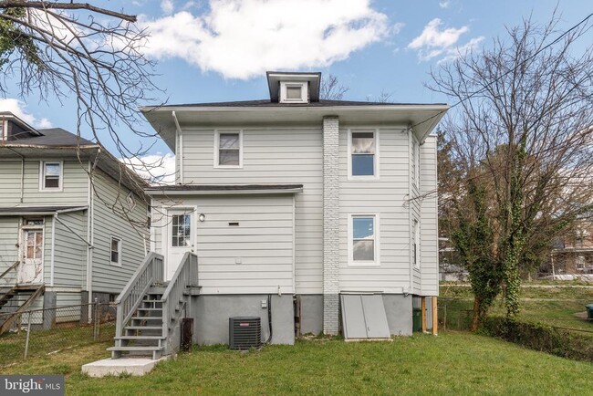
2805 Hamilton Ave
Baltimore, MD 21214
Today
|
Edit
Favorites
347-989-6393
-
Bedrooms
4
-
Bathrooms
2
-
Square Feet
--
-
Available
Available Now
Highlights
- Contemporary Architecture
- 2 Attached Carport Spaces
- Central Air
- Radiator
2805 Hamilton Ave

Favorites
About This Home
Available Now
REMARKABLE RECENTLY TOP TO BOTTOM RENOVATED 4 BEDROOM HOME! TWO CAR PARKING! HUGE BACKYARD! BRAND NEW KITCHEN STAINLESS STEEL APPLIANCES, GORGEOUS COUNTERTOP, ORIGINAL HARDWOOD FLOORING, GREAT LOCATION! SCHEDULE YOUR SHOWING TODAY!
2805 Hamilton Ave is a house located in Baltimore City County and the 21214 ZIP Code. This area is served by the Baltimore City Public Schools attendance zone.
* Price shown is base rent. Excludes user-selected optional fees and variable or usage-based fees and required charges due at or prior to move-in or at move-out. Price, availability, fees, and any applicable rent special are subject to change without notice.
* Square footage definitions vary. Displayed square footage is approximate.
Home Details
Home Type
Single Family Detached Home
Year Built
Built in 1926
Bedrooms and Bathrooms
2 Full Bathrooms
4 Bedrooms
Home Design
Contemporary Architecture
Brick Exterior Construction
Brick Foundation
Block Foundation
Interior Spaces
1,416 Sq Ft Home
Property has 4 Levels
Listing and Financial Details
Security Deposit $2,500
12-Month Min and 36-Month Max Lease Term
Available 1/1/26
Assessor Parcel Number 0327275393 016
Residential Lease
Lot Details
4,573 Sq Ft Lot
Property is zoned R-3
Parking
2 Attached Carport Spaces
Driveway
2 Parking Spaces
Utilities
Central Air
Radiator
Heating System Uses Natural Gas
Natural Gas Water Heater
Septic Pump
Community Details
Overview
Hamilton Heights Subdivision
Pet Policy
Pets allowed on a case-by-case basis
Contact
- Listed by Carter Wise | Real Broker, LLC
- Phone Number
- Contact
-
Source
 Bright MLS, Inc.
Copyright © 2026 Bright MLS, Inc.
Location
Get Directions
Harford-Echodale-Perring Parkway is a suburban community situated just five miles north Downtown Baltimore. The western border of the neighborhood runs along Mount Pleasant Woods Park, providing residents with a scenic escape close to home. The majority of Harford-Echodale-Perring Parkway is residential with an array of affordable apartments for rent. For shopping and dining, residents have the choice of going into Downtown Baltimore or traveling a short distance north into Towson to places like Towson Town Center and Towson Place. Additional features surrounding this neighborhood include sprawling golf courses and community parks.
Learn more about living in Harford-Echodale-Perring Parkway
Amenities
- Basement
Education
| Colleges & Universities | Distance | ||
|---|---|---|---|
| Colleges & Universities | Distance | ||
| Drive: | 5 min | 1.7 mi | |
| Drive: | 8 min | 3.0 mi | |
| Drive: | 13 min | 4.2 mi | |
| Drive: | 16 min | 4.7 mi |
2805 Hamilton Ave is within 5 minutes or 1.7 miles from Morgan State University. It is also near Loyola University Maryland and Notre Dame of Md. Univ..
Schools


Public Elementary & Middle School
Grades PK-8
815 Students
Attendance Zone
Public Middle & High School
Grades 6-12
306 Students
Attendance Zone
Public Middle & High School
Grades 6-12
297 Students
Attendance Zone
Charter High School
Grades 9-12
425 Students
Attendance Zone
Private Elementary, Middle & High School
Grades PK-12
32 Students
Nearby
School data provided by
 The GreatSchools Rating helps parents compare schools within a state based on a variety of school quality indicators and provides a helpful picture of how effectively each school serves all of its students. Ratings are on a scale of 1 (below average) to 10 (above average) and can include test scores, college readiness, academic progress, advanced courses, equity, discipline and attendance data. We also advise parents to visit schools, consider other information on school performance and programs, and consider family needs as part of the school selection process.
View GreatSchools Rating Methodology
Data provided by GreatSchools.org © 2026. All rights reserved.
View GreatSchools Rating Methodology
Data provided by GreatSchools.org © 2026. All rights reserved.
Transportation options available in Baltimore include Johns Hopkins Hospital, located 4.9 miles from 2805 Hamilton Ave. 2805 Hamilton Ave is near Baltimore/Washington International Thurgood Marshall, located 19.2 miles or 34 minutes away.
| Transit / Subway | Distance | ||
|---|---|---|---|
| Transit / Subway | Distance | ||
| Drive: | 13 min | 4.9 mi | |
|
|
Drive: | 13 min | 5.0 mi |
|
|
Drive: | 14 min | 5.1 mi |
| Drive: | 14 min | 5.3 mi | |
|
|
Drive: | 16 min | 5.5 mi |
| Commuter Rail | Distance | ||
|---|---|---|---|
| Commuter Rail | Distance | ||
|
|
Drive: | 13 min | 4.9 mi |
| Drive: | 18 min | 6.4 mi | |
| Drive: | 19 min | 7.4 mi | |
| Drive: | 21 min | 9.4 mi | |
| Drive: | 31 min | 16.8 mi |
| Airports | Distance | ||
|---|---|---|---|
| Airports | Distance | ||
|
Baltimore/Washington International Thurgood Marshall
|
Drive: | 34 min | 19.2 mi |
Time and distance from 2805 Hamilton Ave.
| Shopping Centers | Distance | ||
|---|---|---|---|
| Shopping Centers | Distance | ||
| Drive: | 3 min | 1.2 mi | |
| Drive: | 4 min | 1.4 mi | |
| Drive: | 4 min | 1.7 mi |
2805 Hamilton Ave has 3 shopping centers within 1.7 miles, which is about a 4-minute drive. The miles and minutes will be for the farthest away property.
| Parks and Recreation | Distance | ||
|---|---|---|---|
| Parks and Recreation | Distance | ||
|
Herring Run Park
|
Drive: | 6 min | 2.5 mi |
|
Maryland Natural History Society
|
Drive: | 7 min | 2.6 mi |
|
Clifton Park
|
Drive: | 9 min | 3.3 mi |
|
Watson-King Planetarium
|
Drive: | 13 min | 5.0 mi |
|
Maryland Space Grant Consortium Observatory
|
Drive: | 14 min | 5.1 mi |
2805 Hamilton Ave has 5 parks within 5.1 miles, including Herring Run Park, Maryland Natural History Society, and Clifton Park.
| Hospitals | Distance | ||
|---|---|---|---|
| Hospitals | Distance | ||
| Drive: | 5 min | 1.8 mi | |
| Drive: | 10 min | 4.2 mi | |
| Drive: | 12 min | 4.6 mi |
2805 Hamilton Ave has 3 hospitals within 4.6 miles, the nearest is MedStar Good Samaritan Hospital which is 1.8 miles away and a 5 minute drive.
| Military Bases | Distance | ||
|---|---|---|---|
| Military Bases | Distance | ||
| Drive: | 44 min | 25.6 mi |
2805 Hamilton Ave is 25.6 miles and a 44 minute drive from Fort George Meade.
You May Also Like
Similar Rentals Nearby


What Are Walk Score®, Transit Score®, and Bike Score® Ratings?
Walk Score® measures the walkability of any address. Transit Score® measures access to public transit. Bike Score® measures the bikeability of any address.
What is a Sound Score Rating?
A Sound Score Rating aggregates noise caused by vehicle traffic, airplane traffic and local sources

2805 Hamilton Ave
Baltimore, MD 21214