
$8,000
/ Month
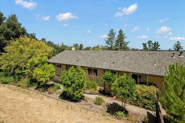
26790 St Francis Rd
Los Altos Hills, CA 94022
2 Weeks Ago
|
Edit
Favorites
26790 St Francis Rd

Favorites
Check Back Soon for Upcoming Availability
| Beds | Baths | Average SF |
|---|---|---|
| 5 Bedrooms 5 Bedrooms 5 Br | 4 Baths 4 Baths 4 Ba | 2,996 SF |
Fees and Policies
The fees below are based on community-supplied data and may exclude additional fees and utilities.
About This Property
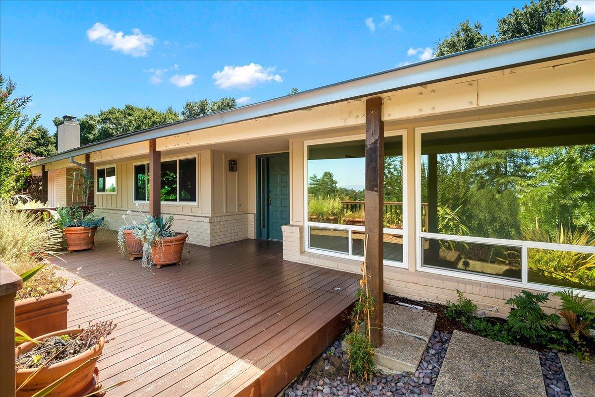
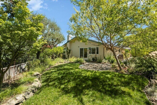
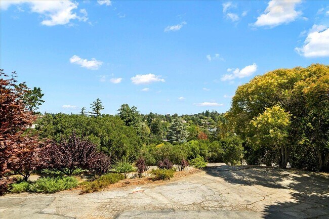
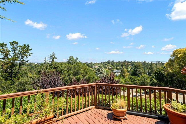
View! View! Property located close to downtown Los Altos. This home offers 5bedrooms 4 Bathrooms that includes 2500 sq. ft of living space in the main house plus a 500 sq. ft 1 bedroom and 1 bathroom ADU, Central AC for the home, inside laundry all on one level. Large picture windows overlook the lush, wrap around yard and the views. Mature landscaping with sprawling decks creates a a serene setting, perfect for entertaining. Palo Alto Unified School District Attendance area( Buyer to verify availability). Easy access to 280 and 101 and tech hubs and the Palo Alto Golf and Country Club and the Los Altos Golf and Country Club. Close to parks, shops and other conveniences. Available to rent immediately for a 6-18 month lease. First Month rent and deposit, includes twice a month gardening service. Easy to show. A MUST SEE!
26790 St Francis Rd is a house located in Santa Clara County and the 94022 ZIP Code. This area is served by the Palo Alto Unified attendance zone.
House Features
- Fireplace
Location
Get Directions
Home to some of Silicon Valley’s biggest movers and shakers, Los Altos is one of the most upscale towns in California and the nation. Tucked within rolling hills with gorgeous views of Silicon Valley, Los Altos Hills boast massive estates, elegant mansions, modern apartments, and posh condos available for rent. To maintain its rural feel, each new home is required to have at least one acre of land. Surrounded by golf clubs, nature preserves, parks, and more, Los Altos Hills is perfect for nature lovers. Apart from housing Foothill College, Los Altos Hills is entirely residential. Thankfully, residents don’t have to go far for shopping, dining, or entertainment since the town is convenient to several other cities such as Los Altos, Mountain View, Santa Clara, and San Francisco. Interstate 280 makes traveling throughout the Bay Area a breeze.
Learn more about living in Los Altos Hills
Amenities
- Fireplace
Education
| Colleges & Universities | Distance | ||
|---|---|---|---|
| Colleges & Universities | Distance | ||
| Drive: | 13 min | 4.1 mi | |
| Drive: | 11 min | 4.1 mi | |
| Drive: | 10 min | 5.2 mi | |
| Drive: | 18 min | 7.5 mi |
26790 St Francis Rd is within 10 minutes or 5.2 miles from Foothill Coll., Los Altos. It is also near Foothill College, Middlefield and Stanford University.
Schools


Public Elementary School
Grades K-5
367 Students
Nearby
Public Elementary School
Grades K-5
358 Students
Attendance Zone
Public Middle School
Grades 6-8
515 Students
Attendance Zone
Public High School
Grades 9-12
1,787 Students
Attendance Zone
Private Elementary & Middle School
Grades 1-8
250 Students
Nearby
Private Elementary & Middle School
Grades K-8
268 Students
Nearby
Private Elementary School
Grades K-1
Nearby
Private Elementary, Middle & High School
Grades K-12
612 Students
Nearby
School data provided by
 The GreatSchools Rating helps parents compare schools within a state based on a variety of school quality indicators and provides a helpful picture of how effectively each school serves all of its students. Ratings are on a scale of 1 (below average) to 10 (above average) and can include test scores, college readiness, academic progress, advanced courses, equity, discipline and attendance data. We also advise parents to visit schools, consider other information on school performance and programs, and consider family needs as part of the school selection process.
View GreatSchools Rating Methodology
Data provided by GreatSchools.org © 2025. All rights reserved.
View GreatSchools Rating Methodology
Data provided by GreatSchools.org © 2025. All rights reserved.
Transportation options available in Los Altos Hills include Mountain View Station, located 5.7 miles from 26790 St Francis Rd. 26790 St Francis Rd is near Norman Y Mineta San Jose International, located 15.0 miles or 27 minutes away, and San Francisco International, located 26.1 miles or 38 minutes away.
| Transit / Subway | Distance | ||
|---|---|---|---|
| Transit / Subway | Distance | ||
| Drive: | 14 min | 5.7 mi | |
|
|
Drive: | 14 min | 5.7 mi |
|
|
Drive: | 17 min | 6.8 mi |
|
|
Drive: | 17 min | 7.0 mi |
| Drive: | 17 min | 7.4 mi |
| Commuter Rail | Distance | ||
|---|---|---|---|
| Commuter Rail | Distance | ||
| Drive: | 10 min | 4.0 mi | |
| Drive: | 10 min | 4.1 mi | |
| Drive: | 11 min | 4.4 mi | |
| Drive: | 14 min | 5.0 mi | |
| Drive: | 15 min | 5.2 mi |
| Airports | Distance | ||
|---|---|---|---|
| Airports | Distance | ||
|
Norman Y Mineta San Jose International
|
Drive: | 27 min | 15.0 mi |
|
San Francisco International
|
Drive: | 38 min | 26.1 mi |
Time and distance from 26790 St Francis Rd.
| Shopping Centers | Distance | ||
|---|---|---|---|
| Shopping Centers | Distance | ||
| Drive: | 9 min | 3.2 mi | |
| Drive: | 10 min | 3.6 mi | |
| Drive: | 10 min | 3.7 mi |
26790 St Francis Rd has 3 shopping centers within 3.7 miles, which is about a 10-minute drive. The miles and minutes will be for the farthest away property.
| Parks and Recreation | Distance | ||
|---|---|---|---|
| Parks and Recreation | Distance | ||
|
Esther Clark Nature Preserve
|
Drive: | 4 min | 1.4 mi |
|
Redwood Grove
|
Drive: | 7 min | 2.3 mi |
|
Terman Park
|
Drive: | 6 min | 2.3 mi |
|
Bol Park
|
Drive: | 11 min | 3.6 mi |
|
Foothill College Observatory
|
Drive: | 11 min | 5.4 mi |
26790 St Francis Rd has 5 parks within 5.4 miles, including Esther Clark Nature Preserve, Terman Park, and Redwood Grove.
| Hospitals | Distance | ||
|---|---|---|---|
| Hospitals | Distance | ||
| Drive: | 13 min | 4.6 mi | |
| Drive: | 12 min | 5.0 mi | |
| Drive: | 13 min | 5.2 mi |
26790 St Francis Rd has 3 hospitals within 5.2 miles, the nearest is El Camino Hospital which is 4.6 miles away and a 13 minute drive.
| Military Bases | Distance | ||
|---|---|---|---|
| Military Bases | Distance | ||
| Drive: | 20 min | 7.9 mi |
26790 St Francis Rd is 7.9 miles and a 20 minute drive from Ames Research Center.
You May Also Like
Similar Rentals Nearby


What Are Walk Score®, Transit Score®, and Bike Score® Ratings?
Walk Score® measures the walkability of any address. Transit Score® measures access to public transit. Bike Score® measures the bikeability of any address.
What is a Sound Score Rating?
A Sound Score Rating aggregates noise caused by vehicle traffic, airplane traffic and local sources

26790 St Francis Rd
Los Altos Hills, CA 94022