

$6,750 / Month
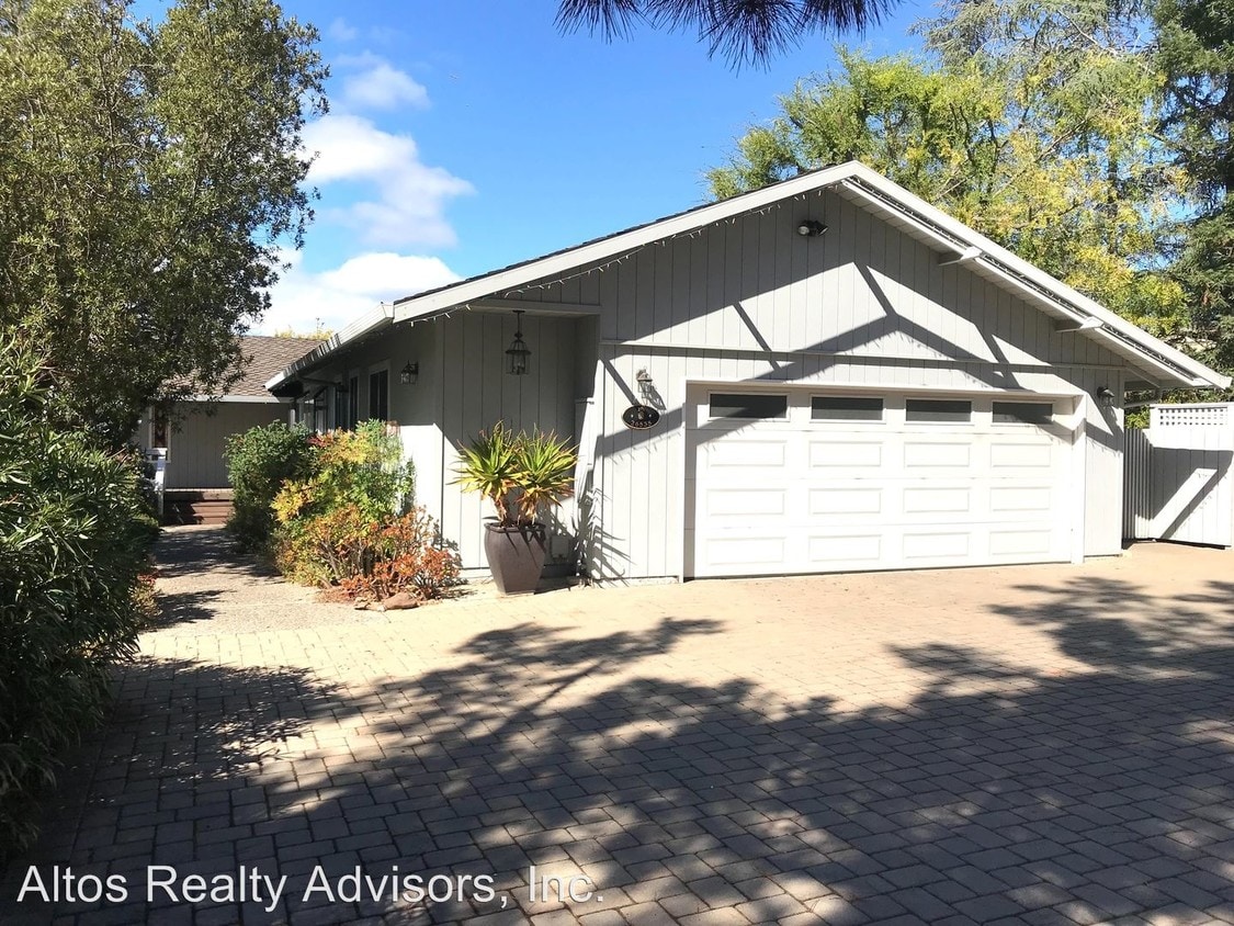
26535 Weston Dr
Los Altos Hills, CA 94022
2 Weeks Ago
Favorites
26535 Weston Dr

Favorites
Check Back Soon for Upcoming Availability
| Beds | Baths | Average SF |
|---|---|---|
| 4 Bedrooms 4 Bedrooms 4 Br | 2.5 Baths 2.5 Baths 2.5 Ba | 2,612 SF |
About This Property
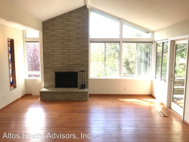
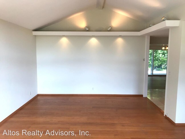
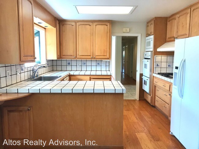
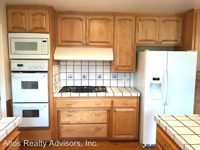
(408) 720-0920 x108 - Desirable Los Altos Hills 4 Bed 2.5 Bath Home Close To Stanford * Great Views * - This Los Altos home sits on an acre lot and features over 2600 square feet of living space in a very desirable neighborhood. It features 4 bedrooms and 2.5 bathrooms, kitchen, living room, family room, two fireplaces, large wine storage in garage, and laundry room. The home has beautiful hardwood flooring throughout and has amazing views of the Mountains. This home is made for entertaining friends and family! This property is across the street to Pinewood. Close to Stanford dish, which makes for great hiking! The property is located close to Stanford, Downtown Los Altos, Foothill College, and Esther Clark Park. Easy access to Highway 280 and Foothill Expressway. Parking 2 Car Garage Driveway This is a non-smoking property Laundry W/D included HVAC Central Forced Air Heating & Air Conditioning Utilities Paid by Tenant Gardener Provided by Owners Schools(*Tenants to Verify*) Lucille M. Nixon Elementary Terman Middle School Henry M. Gunn High School If this doesn’t quite meet your needs, check out our other available properties at www.goaltos.com or give us a call at 408-720-0920. (RLNE4441087)
26535 Weston Dr is a house located in Santa Clara County and the 94022 ZIP Code.
Location
Get Directions
Home to some of Silicon Valley’s biggest movers and shakers, Los Altos is one of the most upscale towns in California and the nation. Tucked within rolling hills with gorgeous views of Silicon Valley, Los Altos Hills boast massive estates, elegant mansions, modern apartments, and posh condos available for rent. To maintain its rural feel, each new home is required to have at least one acre of land. Surrounded by golf clubs, nature preserves, parks, and more, Los Altos Hills is perfect for nature lovers. Apart from housing Foothill College, Los Altos Hills is entirely residential. Thankfully, residents don’t have to go far for shopping, dining, or entertainment since the town is convenient to several other cities such as Los Altos, Mountain View, Santa Clara, and San Francisco. Interstate 280 makes traveling throughout the Bay Area a breeze.
Learn more about living in Los Altos Hills
Education
| Colleges & Universities | Distance | ||
|---|---|---|---|
| Colleges & Universities | Distance | ||
| Drive: | 11 min | 3.6 mi | |
| Drive: | 10 min | 3.8 mi | |
| Drive: | 10 min | 3.8 mi | |
| Drive: | 17 min | 6.8 mi |
26535 Weston Dr is within 10 minutes or 3.8 miles from Foothill Coll., Los Altos. It is also near Foothill College, Middlefield and Stanford University.
Transportation options available in Los Altos Hills include Mountain View Station, located 5.1 miles from 26535 Weston Dr. 26535 Weston Dr is near Norman Y Mineta San Jose International, located 14.5 miles or 25 minutes away, and San Francisco International, located 26.4 miles or 38 minutes away.
| Transit / Subway | Distance | ||
|---|---|---|---|
| Transit / Subway | Distance | ||
| Drive: | 12 min | 5.1 mi | |
|
|
Drive: | 12 min | 5.2 mi |
|
|
Drive: | 15 min | 6.4 mi |
| Drive: | 15 min | 6.9 mi | |
|
|
Drive: | 16 min | 7.1 mi |
| Commuter Rail | Distance | ||
|---|---|---|---|
| Commuter Rail | Distance | ||
| Drive: | 9 min | 3.4 mi | |
| Drive: | 9 min | 3.5 mi | |
| Drive: | 9 min | 3.7 mi | |
| Drive: | 14 min | 4.9 mi | |
| Drive: | 15 min | 5.1 mi |
| Airports | Distance | ||
|---|---|---|---|
| Airports | Distance | ||
|
Norman Y Mineta San Jose International
|
Drive: | 25 min | 14.5 mi |
|
San Francisco International
|
Drive: | 38 min | 26.4 mi |
Time and distance from 26535 Weston Dr.
| Shopping Centers | Distance | ||
|---|---|---|---|
| Shopping Centers | Distance | ||
| Drive: | 7 min | 2.6 mi | |
| Drive: | 8 min | 3.1 mi | |
| Drive: | 9 min | 3.3 mi |
26535 Weston Dr has 3 shopping centers within 3.3 miles, which is about a 9-minute drive. The miles and minutes will be for the farthest away property.
| Parks and Recreation | Distance | ||
|---|---|---|---|
| Parks and Recreation | Distance | ||
|
Esther Clark Nature Preserve
|
Walk: | 11 min | 0.6 mi |
|
Terman Park
|
Drive: | 5 min | 1.8 mi |
|
Redwood Grove
|
Drive: | 6 min | 2.2 mi |
|
Bol Park
|
Drive: | 9 min | 3.0 mi |
|
Foothill College Observatory
|
Drive: | 11 min | 4.0 mi |
26535 Weston Dr has 5 parks within 4.0 miles, including Esther Clark Nature Preserve, Terman Park, and Redwood Grove.
| Hospitals | Distance | ||
|---|---|---|---|
| Hospitals | Distance | ||
| Drive: | 12 min | 4.5 mi | |
| Drive: | 11 min | 4.7 mi | |
| Drive: | 12 min | 4.9 mi |
26535 Weston Dr has 3 hospitals within 4.9 miles, the nearest is El Camino Hospital which is 4.5 miles away and a 12 minute drive.
| Military Bases | Distance | ||
|---|---|---|---|
| Military Bases | Distance | ||
| Drive: | 19 min | 7.3 mi |
26535 Weston Dr is 7.3 miles and a 19 minute drive from Ames Research Center.
You May Also Like
Similar Rentals Nearby


What Are Walk Score®, Transit Score®, and Bike Score® Ratings?
Walk Score® measures the walkability of any address. Transit Score® measures access to public transit. Bike Score® measures the bikeability of any address.
What is a Sound Score Rating?
A Sound Score Rating aggregates noise caused by vehicle traffic, airplane traffic and local sources
26535 Weston Dr
Los Altos Hills, CA 94022