


$3,800 / Month
2610 Defoors Ferry Rd NW
Atlanta, GA 30318
2 Weeks Ago
Favorites
2610 Defoors Ferry Rd NW

Favorites
Check Back Soon for Upcoming Availability
| Beds | Baths | Average SF |
|---|---|---|
| 4 Bedrooms 4 Bedrooms 4 Br | 3 Baths 3 Baths 3 Ba | 2,589 SF |
About This Property
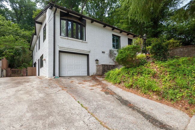
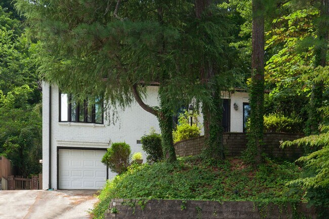
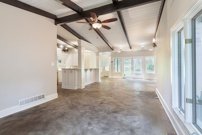
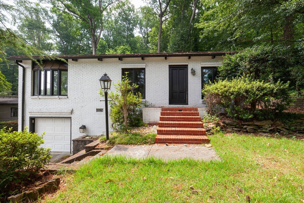
Nestled between Howell Mill Road and Marietta Blvd, this 4bd/3ba home is in one of the most sought after areas in Atlanta. Its location not only allows for easy access to I-75 and I-285, but it's also in the Morris Brandon school district and in close proximity to Westminster, Trinity, and Lovett schools. Uniquely positioned and minutes from Buckhead, Midtown, West Midtown, Westside Park, and the Westside Village at Moores Mill, this area provides countless options for entertainment and recreation! This home also features hardwoods throughout, a kitchen with plenty of cabinet space and center island, stainless-steel appliances, granite countertops and a subway tiled backsplash, a spacious and open living/dining room area leading to an outdoor patio, a large master bedroom on main with a huge walk-in closet and gorgeous master bathroom with stand-in shower, two good size guest rooms on main with full hall bath, a separate in-law suite in the basement w/ ground level entry and full bath, a beautifully landscaped and fully fenced backyard, a covered patio area with fire pit, and a one car garage. The Highland Residential Group, LLC
2610 Defoors Ferry Rd NW is a house located in Fulton County and the 30318 ZIP Code. This area is served by the Atlanta Public Schools attendance zone.
Location
Get Directions
Despite being incorporated only two years ago, South Fulton has already developed a character all its own. Situated partly along the southern section of the Perimeter and stretching southwest over Chattahoochee Hills, South Fulton covers a large portion of residential and undeveloped land. This sprawling area is made up of a number of characterful neighborhoods, all offering access to ATL at a more affordable price.
South Fulton’s entire western border is formed by the Chattahoochee, making it a perfect place for the outdoor-inclined to settle. There’s also plenty of parks and shopping centers to keep residents entertained. Hartsfield-Jackson airport sits on the eastern edge of South Fulton, so if you travel for work but want more space than the city would provide, look no further.
Learn more about living in South FultonBelow are rent ranges for similar nearby apartments
Education
| Colleges & Universities | Distance | ||
|---|---|---|---|
| Colleges & Universities | Distance | ||
| Drive: | 12 min | 5.0 mi | |
| Drive: | 13 min | 6.4 mi | |
| Drive: | 13 min | 6.4 mi | |
| Drive: | 16 min | 7.1 mi |
2610 Defoors Ferry Rd NW is within 12 minutes or 5.0 miles from Georgia Tech. It is also near Clark Atlanta University and Morehouse College.
Schools


Public Elementary School
Grades PK-5
553 Students
Nearby
Public Elementary School
Grades PK-5
865 Students
Attendance Zone
Public Middle School
Grades 6-8
1,548 Students
Attendance Zone
Public High School
Grades 9-12
2,316 Students
Attendance Zone
Private Elementary School
Grades PK-6
345 Students
Nearby
Private Middle & High School
Grades 6-12
215 Students
Nearby
School data provided by
 The GreatSchools Rating helps parents compare schools within a state based on a variety of school quality indicators and provides a helpful picture of how effectively each school serves all of its students. Ratings are on a scale of 1 (below average) to 10 (above average) and can include test scores, college readiness, academic progress, advanced courses, equity, discipline and attendance data. We also advise parents to visit schools, consider other information on school performance and programs, and consider family needs as part of the school selection process.
View GreatSchools Rating Methodology
Data provided by GreatSchools.org © 2025. All rights reserved.
View GreatSchools Rating Methodology
Data provided by GreatSchools.org © 2025. All rights reserved.
Transportation options available in Atlanta include Bankhead, located 4.5 miles from 2610 Defoors Ferry Rd NW. 2610 Defoors Ferry Rd NW is near Hartsfield - Jackson Atlanta International, located 17.9 miles or 28 minutes away.
| Transit / Subway | Distance | ||
|---|---|---|---|
| Transit / Subway | Distance | ||
|
|
Drive: | 9 min | 4.5 mi |
|
|
Drive: | 13 min | 5.8 mi |
|
|
Drive: | 11 min | 6.2 mi |
|
|
Drive: | 12 min | 6.5 mi |
|
|
Drive: | 16 min | 10.3 mi |
| Commuter Rail | Distance | ||
|---|---|---|---|
| Commuter Rail | Distance | ||
|
|
Drive: | 9 min | 4.0 mi |
| Airports | Distance | ||
|---|---|---|---|
| Airports | Distance | ||
|
Hartsfield - Jackson Atlanta International
|
Drive: | 28 min | 17.9 mi |
Time and distance from 2610 Defoors Ferry Rd NW.
| Shopping Centers | Distance | ||
|---|---|---|---|
| Shopping Centers | Distance | ||
| Walk: | 10 min | 0.5 mi | |
| Walk: | 14 min | 0.7 mi | |
| Drive: | 3 min | 1.3 mi |
2610 Defoors Ferry Rd NW has 3 shopping centers within 1.3 miles, which is about a 3-minute walk. The miles and minutes will be for the farthest away property.
| Parks and Recreation | Distance | ||
|---|---|---|---|
| Parks and Recreation | Distance | ||
|
Atlanta History Center
|
Drive: | 10 min | 4.5 mi |
|
Silver Comet Trail
|
Drive: | 12 min | 5.9 mi |
|
Piedmont Park
|
Drive: | 12 min | 6.7 mi |
|
Atlanta Botanical Garden
|
Drive: | 12 min | 7.1 mi |
|
Georgia Conservancy
|
Drive: | 13 min | 7.5 mi |
2610 Defoors Ferry Rd NW has 5 parks within 7.5 miles, including Atlanta History Center, Silver Comet Trail, and Georgia Conservancy.
| Hospitals | Distance | ||
|---|---|---|---|
| Hospitals | Distance | ||
| Drive: | 8 min | 3.5 mi | |
| Drive: | 10 min | 5.5 mi | |
| Drive: | 12 min | 7.3 mi |
2610 Defoors Ferry Rd NW has 3 hospitals within 7.3 miles, the nearest is Piedmont Hospital which is 3.5 miles away and a 8 minute drive.
| Military Bases | Distance | ||
|---|---|---|---|
| Military Bases | Distance | ||
| Drive: | 20 min | 9.7 mi | |
| Drive: | 20 min | 9.8 mi |
2610 Defoors Ferry Rd NW is 9.7 miles from Fort McPherson, and is convenient to other military bases, including Dobbins Air Force Base.
You May Also Like
Similar Rentals Nearby


What Are Walk Score®, Transit Score®, and Bike Score® Ratings?
Walk Score® measures the walkability of any address. Transit Score® measures access to public transit. Bike Score® measures the bikeability of any address.
What is a Sound Score Rating?
A Sound Score Rating aggregates noise caused by vehicle traffic, airplane traffic and local sources
2610 Defoors Ferry Rd NW
Atlanta, GA 30318