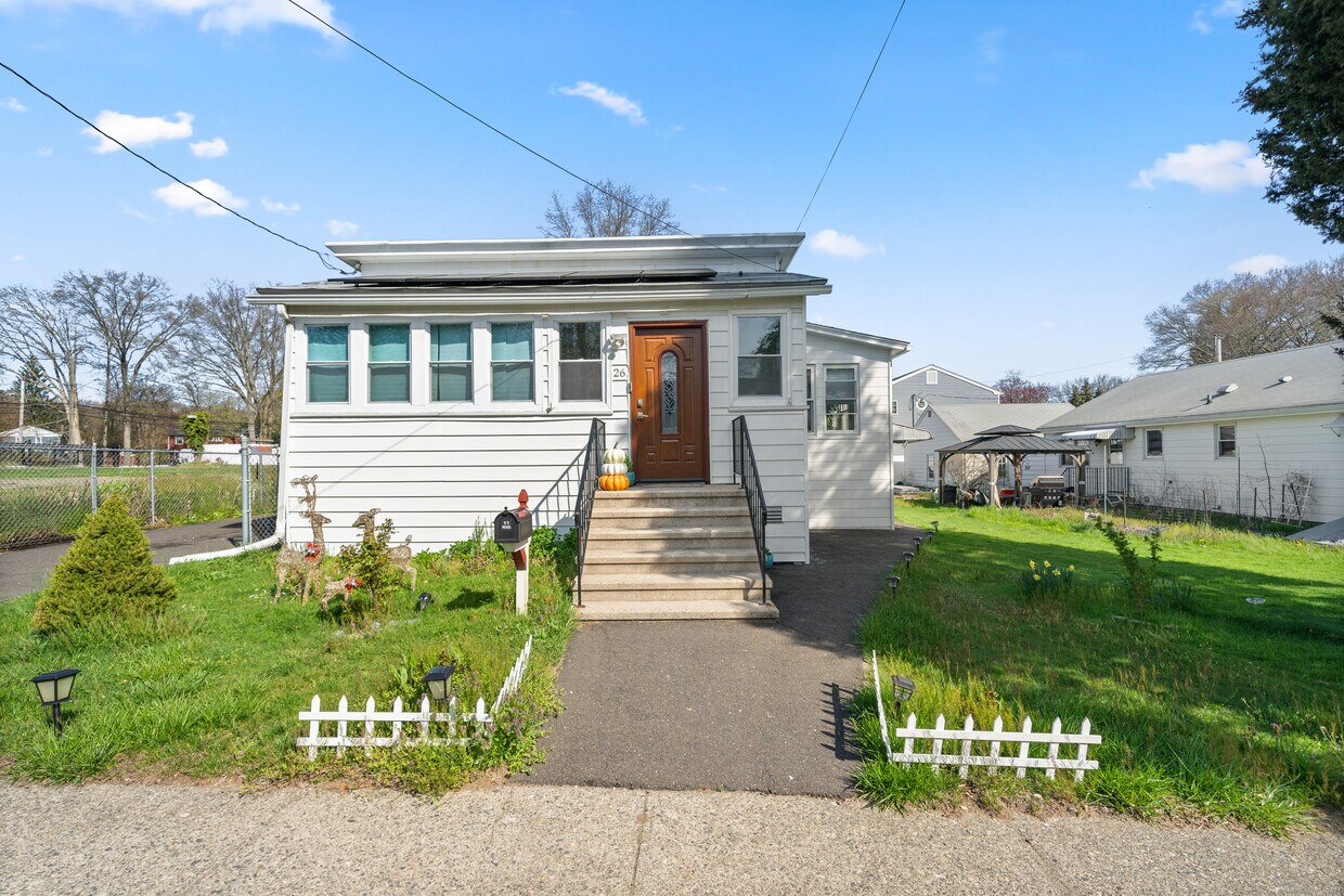
$3,000 Total Monthly Price

26 Porter St

,

Stratford, CT 06614

Share Listing
Favorites
26 Porter St
Share Listing
Favorites

Check Back Soon for Upcoming Availability

Beds Baths Average SF
3 Bedrooms 3 Bedrooms 3 Br 1 Bath 1 Bath 1 Ba

Fees and Policies

The fees listed below are community-provided and may exclude utilities or add-ons. All payments are made directly to the property and are non-refundable unless otherwise specified.

  • Dogs Allowed
  • Fees not specified
  • Cats Allowed
  • Fees not specified

About This Property

Ranch style home partially renovated. Interior Features include: 5 Rooms : 4-5 Bedrooms : 2 bathrooms : Newer White kitchen Cabinets : Newer Appliances : Enclosed front porch ( 128 sq ft.) : Washer & Dryer area in Lower Level : Storage in Basement. Exterior Features include: 1 Car garage Detached (235 sq ft.) : Car Port (129 sq ft.) : Covered Patio & Deck ( 212 sq ft.) : Shed : Fenced in Yard : Newer Driveway. Exciting Area features include: 1/2 mile to all major shopping : 1/4 mile to the park : 1.4 miles to the Merritt Parkway : 1.2 miles to Route 8 : 1.1 miles to Startford train station : 2 miles to I-95 N & S ramps : 1.8 miles to Short beach : 1.7 miles to Bridgeport hospital, Yale

26 Porter St is a house located in Fairfield County and the 06614 ZIP Code. This area is served by the Stratford School District attendance zone.

Location
26 Porter St, Stratford,
CT 06614
Get Directions
| Edit

Under 30 minutes

Commute Time is calculated at rush hour.
Neighborhood

Trumbull/Upper Stratford/Shelton is an expansive area encompassing the land north of Bridgeport and Lower Stratford. The area is largely residential and complemented by lush woods. Renters have options of modern apartments and townhomes for rent. Although this community is mostly residential, Highways 25 and 8 allow for easy travel to surrounding areas, including the 25-mile drive east to New Haven and the 70-mile drive to New York. These two roads also hold the main retail areas including places like Hawley Lane Mall and Westfield Trumbull. Outside of this area, residents are in proximity to some of Connecticut’s best attractions like the Connecticut’s Beardsley Zoo and the Roosevelt Forest.

Learn more about living in Trumbull/Upper Stratford/Shelton 

Below are rent ranges for similar nearby apartments

Education
Colleges & Universities Distance
Drive: 9 min 6.0 mi
Drive: 13 min 6.4 mi
Drive: 16 min 10.1 mi
Drive: 17 min 10.8 mi
26 Porter St is within 9 minutes or 6.0 miles from University of Bridgeport. It is also near Sacred Heart University and Fairfield University.
Schools
Public Elementary School
Grades K-5
594 Students
Attendance Zone
Public Middle School
Grades 6-8
489 Students
Attendance Zone
Public High School
Grades 9-12
1,042 Students
Attendance Zone
Private Elementary & Middle School
Grades PK-8
222 Students
Nearby
Private Elementary, Middle & High School
Grades K-12
22 Students
Nearby
Transportation

26 Porter St is near Tweed/New Haven, located 20.3 miles or 33 minutes away, and Long Island MacArthur, located 39.6 miles or 116 minutes away.

Commuter Rail Distance
Drive: 3 min 2.0 mi
Drive: 9 min 4.4 mi
Drive: 11 min 6.3 mi
Drive: 14 min 8.2 mi
Drive: 15 min 10.0 mi
Airports Distance
Airports Distance
Tweed/New Haven
Drive: 33 min 20.3 mi
Long Island MacArthur
Drive: 116 min 39.6 mi

Walkability Near 26 Porter St Stratford, CT 06614

Getting Around
Fairly Walkable
Walkability
50 / 100
Some Public Transit
Transit
40 / 100
Very Drivable
Drivability
80 / 100
Fairly Bikeable
Bikeability
40 / 100

Scores provided by

What do Walkability, Transit, Drivability, and Bikeability mean? Walkability measures the walking distance to day-to-day needs. Transit measures access to public transportation. Drivability measures congestion, parking availability, and access to major roads. Bikeability measures the suitability for cycling. How It Works
-
Soundscore
- / 100

Traffic

-

Airport

-

Businesses

-

Scores provided by

HowLoud What is a Sound Score Rating? A Sound Score Rating aggregates noise caused by vehicle traffic, airplane traffic and local sources. How It Works
Points of Interest

Time and distance from 26 Porter St.

Shopping Centers Distance
Drive: 3 min 1.4 mi
Drive: 3 min 1.6 mi
Drive: 4 min 1.9 mi
26 Porter St has 3 shopping centers within 1.9 miles, which is about a 4-minute drive. The miles and minutes will be for the farthest away property.
Parks and Recreation Distance
Beardsley Zoo
Drive: 5 min 2.8 mi
Boothe Memorial Park and Museum
Drive: 7 min 3.8 mi
Silver Sands State Park
Drive: 10 min 5.6 mi
Discovery Museum and Planetarium
Drive: 12 min 6.5 mi
Audubon Center at Milford Point
Drive: 13 min 6.8 mi
26 Porter St has 5 parks within 6.8 miles, including Beardsley Zoo, Boothe Memorial Park and Museum, and Silver Sands State Park.
Hospitals Distance
Hospitals Distance
Drive: 5 min 2.2 mi
Drive: 5 min 2.2 mi
Drive: 8 min 4.3 mi
26 Porter St has 3 hospitals within 4.3 miles, the nearest is Bridgeport Hospital which is 2.2 miles away and a 5 minute drive.
Military Bases Distance
Drive: 137 min 51.5 mi
Drive: 82 min 56.6 mi
Drive: 82 min 57.8 mi
26 Porter St has 3 military bases within 57.8 miles, the nearest is Eatons Neck CG Station North which is 51.5 miles away and a 137 minute drive.

You May Also Like

Similar Rentals Nearby