
$2,100
/ Month
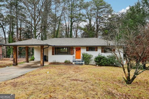
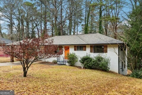
2562 Farley St
East Point, GA 30344
1 Day Ago
|
Edit
Favorites
678-520-9292
-
Bedrooms
4
-
Bathrooms
2
-
Square Feet
2,746 sq ft
-
Available
Available Now
Highlights
- Property is near public transit and shops
- 2-Story Property
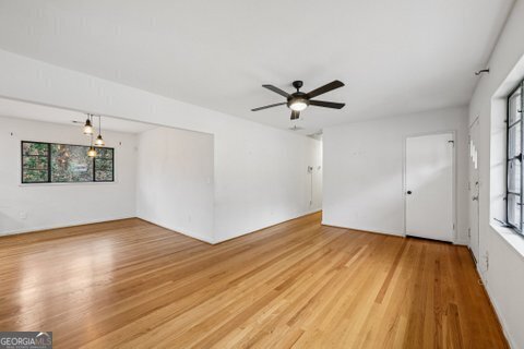
- Wood Flooring
- Main Floor Primary Bedroom
- Den
- Breakfast Area or Nook
2562 Farley St

Favorites
About This Home
$2,200 deposit,
Available Now
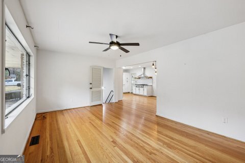
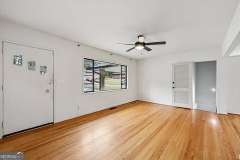
Mid-century modern ranch home ready for a new family. The home features hardwood floors through and carpet in the master bedroom. Home has been updated with new electrical,plumbing,roof, gutters, HVAC and Nest thermostat. Master with double closets with barn doors. Kitchen with 36 range top with granite counter tops. Partially finished basement with 2 rooms plus den with fireplace. Well located to bike trail,shopping and 166." MLS ID 10655157
2562 Farley St is a house located in Fulton County and the 30344 ZIP Code. This area is served by the Fulton County attendance zone.
* Price shown is base rent. Excludes user-selected optional fees and variable or usage-based fees and required charges due at or prior to move-in or at move-out. Price, availability, fees, and any applicable rent special are subject to change without notice.
* Square footage definitions vary. Displayed square footage is approximate.
Home Details
Home Type
Single Family Detached Home
Year Built
Built in 1958 | Remodeled
Basement
Natural lighting in basement
Basement Fills Entire Space Under The House
Fireplace in Basement
Laundry in Basement
Bedrooms and Bathrooms
4 Bedrooms | 2 Main Level Bedrooms
Primary Bedroom on Main
Double Vanity
Walk-In Closet
Bathtub Includes Tile Surround
Separate Shower
2 Full Bathrooms
Home Design
2-Story Property
Brick Exterior Construction
Composition Roof
Interior Spaces
Wood Flooring
Den
Ceiling Fan
2,746 Sq Ft Home
Kitchen
Breakfast Area or Nook
Built-In Oven
Cooktop
Dishwasher
Listing and Financial Details
Security Deposit $2,200
$95 Application Fee
Location
Property is near public transit and shops
Lot Details
0.31 Acre Lot
Level Lot
Parking
Carport
Schools
Briar Hills Elementary School
Paul D West Middle School
Tri Cities High School
Utilities
Central Air
High Speed Internet
Gas Water Heater
Cable TV Available
Heat Pump System
Community Details
Overview
No Home Owners Association
Conley Hills Subdivision
Pet Policy
Call for details about the types of pets allowed
Fees and Policies
The fees below are based on community-supplied data and may exclude additional fees and utilities.
-
One-Time Basics
-
Due at Application
-
Application Fee Per ApplicantCharged per applicant.$95
-
-
Due at Move-In
-
Security Deposit - RefundableCharged per unit.$2,200
-
-
Due at Application
Property Fee Disclaimer: Based on community-supplied data and independent market research. Subject to change without notice. May exclude fees for mandatory or optional services and usage-based utilities.
Contact
- Listed by Bruce Ailion | RE/MAX Town & Country
- Phone Number
- Contact
-
Source
 Georgia Multiple Listing Service
Copyright © 2026 Georgia Multiple Listing Service. All rights reserved. All information provided by the listing agent / broker is deemed reliable but is not guaranteed and should be independently verified.
Location
Get Directions
Amenities
- Double Vanities
- Dishwasher
- Refrigerator
- Breakfast Nook
- Den
Aerotropolis refers to an array of Southside Atlanta communities surrounding Hartsfield-Jackson Atlanta International Airport, the world’s busiest airport. The cities of College Park, Chattahoochee Hills, East Point, Fairburn, Forest Park, Union City, Hapeville, Morrow, and Palmetto are all a part of the Aerotropolis Alliance, working together on initiatives to improve their respective communities.
Aerotropolis’ close proximity to the airport makes the region an ideal choice for local employees and frequent travelers alike. A wide variety of rentals are available throughout the region, from luxury apartments and cozy condos to charming townhomes and spacious houses. Getting around from Aerotropolis is easy with access to I-75, I-85, and I-285.
Learn more about living in Aerotropolis
Education
| Colleges & Universities | Distance | ||
|---|---|---|---|
| Colleges & Universities | Distance | ||
| Drive: | 11 min | 5.1 mi | |
| Drive: | 12 min | 5.8 mi | |
| Drive: | 14 min | 5.9 mi | |
| Drive: | 14 min | 6.1 mi |
2562 Farley St is within 11 minutes or 5.1 miles from Atlanta Metropolitan State. It is also near Atlanta Technical College and Morehouse School of Medicine.
Schools


Public Elementary School
Grades PK-5
397 Students
Attendance Zone
Public Middle School
Grades 6-8
803 Students
Attendance Zone
Public High School
Grades 9-12
1,483 Students
Attendance Zone
Private Elementary, Middle & High School
Grades PK-12
Nearby
Private Elementary School
Grades PK-6
32 Students
Nearby
School data provided by
 The GreatSchools Rating helps parents compare schools within a state based on a variety of school quality indicators and provides a helpful picture of how effectively each school serves all of its students. Ratings are on a scale of 1 (below average) to 10 (above average) and can include test scores, college readiness, academic progress, advanced courses, equity, discipline and attendance data. We also advise parents to visit schools, consider other information on school performance and programs, and consider family needs as part of the school selection process.
View GreatSchools Rating Methodology
Data provided by GreatSchools.org © 2026. All rights reserved.
View GreatSchools Rating Methodology
Data provided by GreatSchools.org © 2026. All rights reserved.
Transportation options available in East Point include East Point, located 2.1 miles from 2562 Farley St. 2562 Farley St is near Hartsfield - Jackson Atlanta International, located 7.3 miles or 15 minutes away.
| Transit / Subway | Distance | ||
|---|---|---|---|
| Transit / Subway | Distance | ||
|
|
Drive: | 5 min | 2.1 mi |
|
|
Drive: | 7 min | 3.4 mi |
|
|
Drive: | 7 min | 3.8 mi |
|
|
Drive: | 7 min | 4.2 mi |
|
|
Drive: | 11 min | 5.7 mi |
| Commuter Rail | Distance | ||
|---|---|---|---|
| Commuter Rail | Distance | ||
|
|
Drive: | 21 min | 12.6 mi |
| Airports | Distance | ||
|---|---|---|---|
| Airports | Distance | ||
|
Hartsfield - Jackson Atlanta International
|
Drive: | 15 min | 7.3 mi |
Time and distance from 2562 Farley St.
| Shopping Centers | Distance | ||
|---|---|---|---|
| Shopping Centers | Distance | ||
| Walk: | 7 min | 0.4 mi | |
| Walk: | 8 min | 0.4 mi | |
| Drive: | 4 min | 1.5 mi |
2562 Farley St has 3 shopping centers within 1.5 miles, which is about a 4-minute drive. The miles and minutes will be for the farthest away property.
| Parks and Recreation | Distance | ||
|---|---|---|---|
| Parks and Recreation | Distance | ||
|
West Atlanta Watershed Alliance (WAWA)
|
Drive: | 10 min | 4.0 mi |
|
Cascade Springs Nature Preserve
|
Drive: | 10 min | 4.1 mi |
|
Atlanta BeltLine Southwest Connector Spur Trail
|
Drive: | 12 min | 4.8 mi |
|
Park Pride
|
Drive: | 13 min | 6.6 mi |
|
The Georgia Capitol Museum
|
Drive: | 14 min | 7.1 mi |
2562 Farley St has 5 parks within 7.1 miles, including Cascade Springs Nature Preserve, West Atlanta Watershed Alliance (WAWA), and Atlanta BeltLine Southwest Connector Spur Trail.
| Hospitals | Distance | ||
|---|---|---|---|
| Hospitals | Distance | ||
| Drive: | 15 min | 7.5 mi | |
| Drive: | 16 min | 8.2 mi | |
| Drive: | 18 min | 8.5 mi |
2562 Farley St has 3 hospitals within 8.5 miles, the nearest is Grady Memorial Hospital which is 7.5 miles away and a 15 minute drive.
| Military Bases | Distance | ||
|---|---|---|---|
| Military Bases | Distance | ||
| Drive: | 9 min | 4.0 mi | |
| Drive: | 26 min | 12.9 mi |
2562 Farley St is 4.0 miles from Fort McPherson, and is convenient to other military bases, including Fort Gillem.
You May Also Like
Similar Rentals Nearby
-
-
1 / 58

-
-
-
-
-
-

-
-


What Are Walk Score®, Transit Score®, and Bike Score® Ratings?
Walk Score® measures the walkability of any address. Transit Score® measures access to public transit. Bike Score® measures the bikeability of any address.
What is a Sound Score Rating?
A Sound Score Rating aggregates noise caused by vehicle traffic, airplane traffic and local sources

2562 Farley St
East Point, GA 30344