

$4,295 / Month
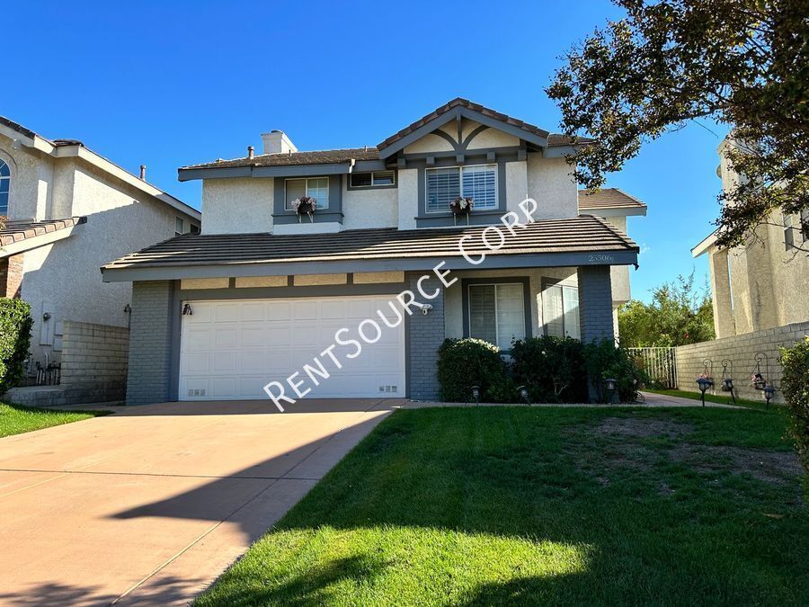
25506 Paine Cir
Stevenson Ranch, CA 91381
Today
Favorites
661-430-5355
-
Bedrooms
4
-
Bathrooms
3
-
Square Feet
2,363 sq ft
-
Available
Available Jul 4
25506 Paine Cir

Favorites
About This Home
Available Jul 4
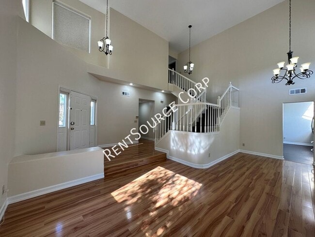
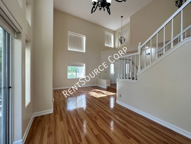
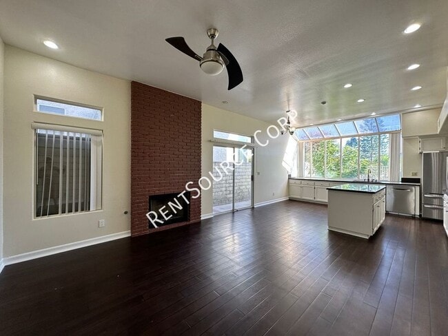
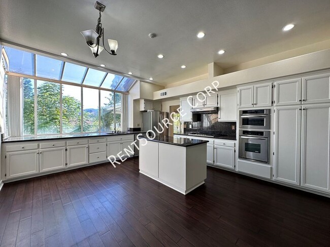
---- SCHEDULE A SHOWING ONLINE AT: ---- Santa Clarita Rental located off of Stevenson Ranch Pkwy and Stafford Canyon Rd. Upgraded 4 bedroom, 3 bathroom home with 7.15 kilowatt Solar! Livingroom with vaulted ceilings and adjacent to dining room. The Large gourmet kitchen with center island, stainless steel appliances, great counter and cabinet space and wall of windows which overlooks the backyard and breathtaking mountain views. Downstairs is 1 bedroom and a full bathroom. Upstairs you will find the Large master suite featuring high ceilings, fireplace, Large walk in closet and ensuite bathroom with double sink vanity and soaking tub with separate shower. 2 additional bedrooms upstairs with a hall bathroom. Hard flooring throughout (no carpet), downstairs laundry room with washer/dryer included. Home is equipped with Smart devices such as thermostat, switches, lightbulbs, thermostat and a Ring camera security system. Attached direct access garage with lots of storage and EV charger setup. Spacious private backyard with beautiful views. Close to Shopping, Restaurants and Award Winning Schools. Refrigerator, Washer/Dryer Included (without warranty) Gardener Included and outside Pest Control 1x month Pets ok Available Now! Please visit
Unique Features
- SharedYard
25506 Paine Cir is a house located in Los Angeles County and the 91381 ZIP Code.
* Price shown is base rent and may not include non-optional fees and utilities.
Price, availability, fees, and any applicable rent special are subject to change without notice.
* Square footage definitions vary. Displayed square footage is approximate.
Fees and Policies
The fees below are based on community-supplied data and may exclude additional fees and utilities.
- Dogs Allowed
-
Fees not specified
- Cats Allowed
-
Fees not specified
Contact
- Listed by RentSource
- Phone Number
- Contact
Location
Get Directions
Amenities
- SharedYard
Santa Clarita Valley, which lies just 12 miles north of San Fernando and 33 miles north of Los Angeles, has it all: proximity to the culture and nightlife of urban California while still being surrounded by nature. Pacerita Canyon Nature Area, 13 minutes to the east, features 350 acres of wilderness and 12 miles of trails, perfect for hiking enthusiasts or families introducing children to the wonders of nature. For instance, the Heritage Trail teaches kids about the cultural history of the area. Locals enjoy spending a long weekend or a warm day at the Castaic Lake Recreation Area, 15 minutes from their homes, for boating and swimming during the day and enjoying s'mores at night.
When not exploring the great outdoors, locals drive 12 minutes south to the downtown area to enjoy a hot bowl of stew at Souplantation or homemade Italian cooking at Sisley's.
Learn more about living in Santa Clarita Valley
Education
| Colleges & Universities | Distance | ||
|---|---|---|---|
| Colleges & Universities | Distance | ||
| Drive: | 8 min | 3.2 mi | |
| Drive: | 18 min | 13.0 mi | |
| Drive: | 25 min | 14.4 mi | |
| Drive: | 35 min | 26.3 mi |
25506 Paine Cir is within 8 minutes or 3.2 miles from College of the Canyons. It is also near Mission College and Cal State Northridge.
You May Also Like
Similar Rentals Nearby


What Are Walk Score®, Transit Score®, and Bike Score® Ratings?
Walk Score® measures the walkability of any address. Transit Score® measures access to public transit. Bike Score® measures the bikeability of any address.
What is a Sound Score Rating?
A Sound Score Rating aggregates noise caused by vehicle traffic, airplane traffic and local sources
25506 Paine Cir
Stevenson Ranch, CA 91381