
$2,500
/ Month
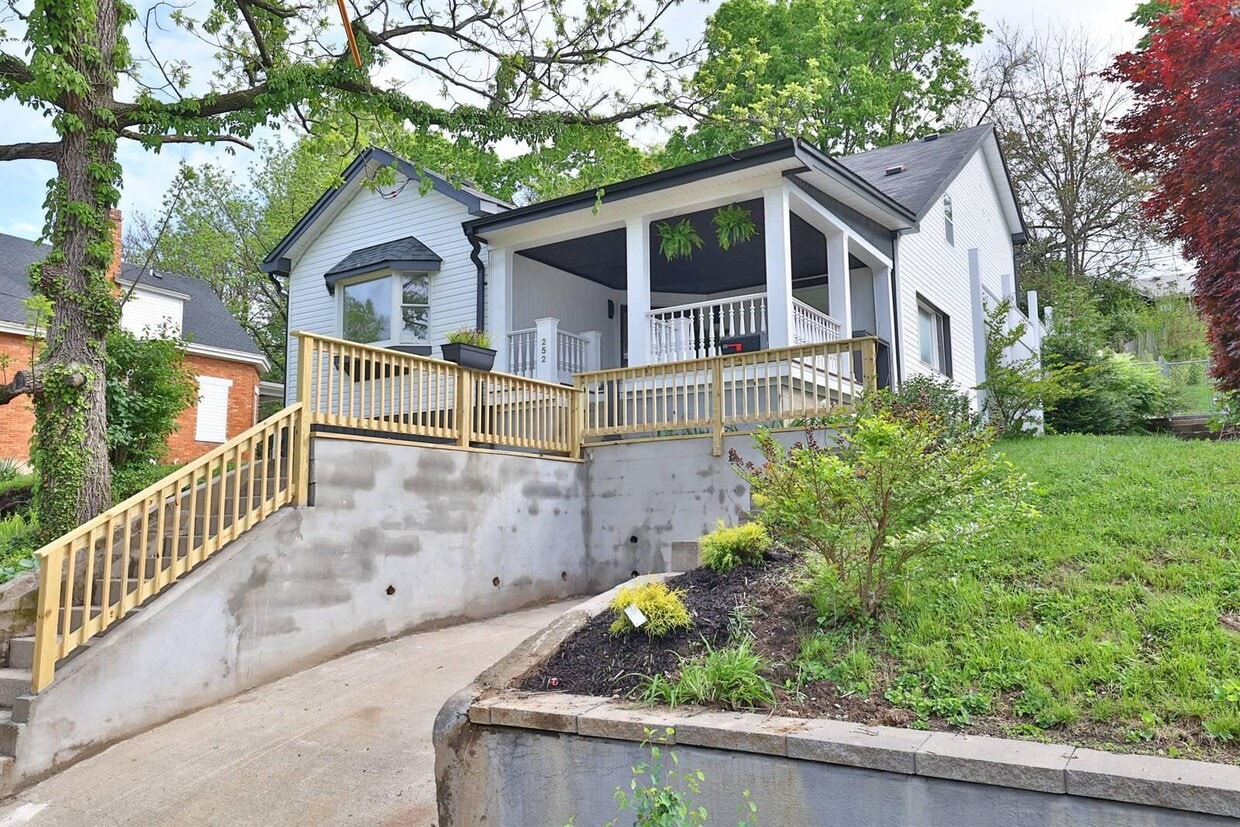
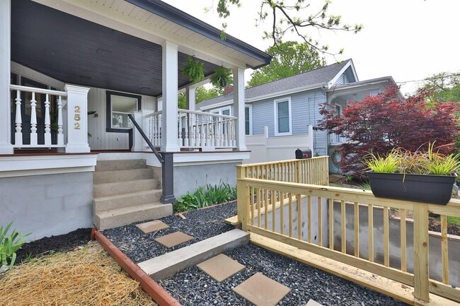
252 Linden Ave
Southgate, KY 41071
Today
|
Edit
Favorites
859-640-5000
-
Bedrooms
4
-
Bathrooms
3
-
Square Feet
1,243 sq ft
-
Available
Available Now
Highlight
- Fireplace
252 Linden Ave

Favorites
About This Home
Available Now
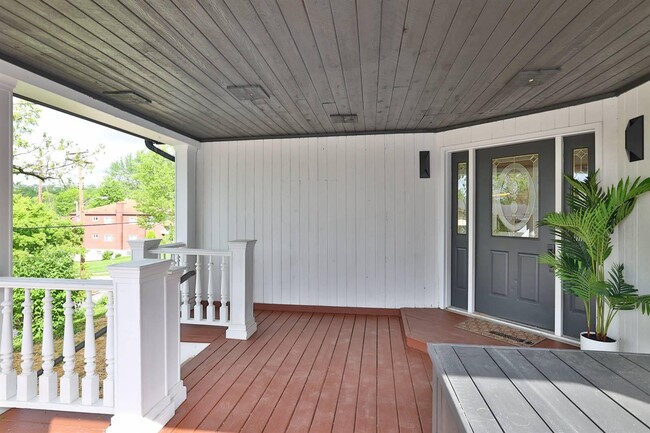
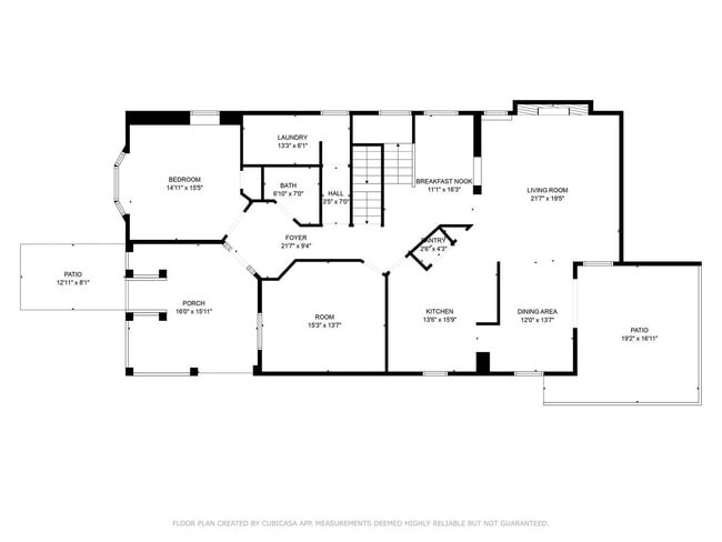
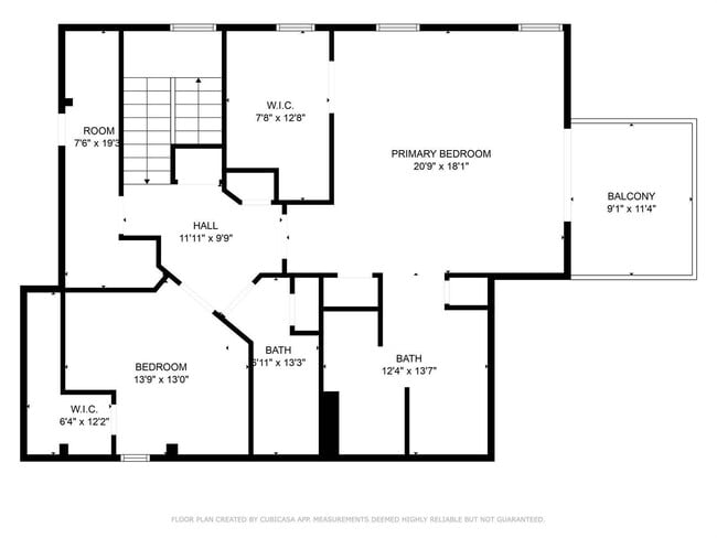
Don't miss this rental for your new home! Looking for prime location for your rental this is it along with so much space! This home is larger than it looks with 2,460 sq feet of living area! 4 beds,3 baths! All new luxury vinyl on first floor. New carpet in all bedrooms. All new tiled bathrooms. Brand new kitchen with leathered granite counter tops. Fireplace. Private balcony off of primary suite,large primary bath and walk in closet. 1st floor laundry. Private patio. Off street parking. Fort Thomas School Eligible Per Guidelines of Lottery System. Make this home yours today! Pets allowed with a non-refundable deposit.
252 Linden Ave is a house located in Campbell County and the 41071 ZIP Code. This area is served by the Southgate Independent attendance zone.
* Price shown is base rent. Excludes user-selected optional fees and variable or usage-based fees and required charges due at or prior to move-in or at move-out. Price, availability, fees, and any applicable rent special are subject to change without notice.
* Square footage definitions vary. Displayed square footage is approximate.
House Features
Air Conditioning
Dishwasher
Fireplace
Oven
- Air Conditioning
- Fireplace
- Dishwasher
- Oven
- Range
- Views
Contact
- Listed by Mckensi Madden | Sibcy Cline,REALTORS-Florence
- Phone Number
- Contact
-
Source
Northern Kentucky Association of REALTORS®
Copyright © 2025 Northern Kentucky Association of REALTORS. All rights reserved. All information provided by the listing agent/broker is deemed reliable but is not guaranteed and should be independently verified.
Location
Get Directions
Amenities
- Air Conditioning
- Fireplace
- Dishwasher
- Oven
- Range
- Views
A densely wooded suburb of Campbell County, Southgate is made up of a golf course, residential neighborhoods, and open land. Southgate’s residential streets are lined with paved sidewalks, well-maintained lawns, and unique craftsman style homes. A portion of the Highland County Club sits within Southgate, while the remainder of the course lies within Fort Thomas, Southgate’s riverfront neighbor.
Southgate is just a few miles west of the Ohio River and the Kentucky-Ohio state line. With Interstate 471 traveling directly through town, locals can easily get into Cincinnati, Ohio, which is just five miles northwest of town. Though Southgate is located in Kentucky, it’s closer to Ohio’s major metro areas! Residents can also travel south along Interstates 471 and 275, or back roads, to reach Northern Kentucky University directly south of Southgate.
Learn more about living in Southgate
Education
| Colleges & Universities | Distance | ||
|---|---|---|---|
| Colleges & Universities | Distance | ||
| Drive: | 8 min | 4.1 mi | |
| Drive: | 13 min | 7.3 mi | |
| Drive: | 13 min | 7.4 mi | |
| Drive: | 16 min | 8.8 mi |
252 Linden Ave is within 8 minutes or 4.1 miles from Northern Kentucky University. It is also near University of Cincinnati and Univ. of Cincinnati, Medical.
Schools


Public Elementary & Middle School
Grades PK-8
207 Students
Attendance Zone
Public High School
Grades 9-12
1,015 Students
Nearby
Private Elementary & Middle School
Grades PK-8
213 Students
Nearby
Private Elementary & Middle School
Grades K-8
148 Students
Nearby
Private High School
Grades 9-12
256 Students
Nearby
School data provided by
 The GreatSchools Rating helps parents compare schools within a state based on a variety of school quality indicators and provides a helpful picture of how effectively each school serves all of its students. Ratings are on a scale of 1 (below average) to 10 (above average) and can include test scores, college readiness, academic progress, advanced courses, equity, discipline and attendance data. We also advise parents to visit schools, consider other information on school performance and programs, and consider family needs as part of the school selection process.
View GreatSchools Rating Methodology
Data provided by GreatSchools.org © 2025. All rights reserved.
View GreatSchools Rating Methodology
Data provided by GreatSchools.org © 2025. All rights reserved.
Transportation options available in Southgate include 247 Telemarketing Station, 4Th & Main, located 3.0 miles from 252 Linden Ave. 252 Linden Ave is near Cincinnati/Northern Kentucky International, located 15.9 miles or 29 minutes away.
| Transit / Subway | Distance | ||
|---|---|---|---|
| Transit / Subway | Distance | ||
| Drive: | 8 min | 3.0 mi | |
| Drive: | 9 min | 3.1 mi | |
| Drive: | 8 min | 5.1 mi | |
| Drive: | 9 min | 5.2 mi | |
| Drive: | 9 min | 5.3 mi |
| Commuter Rail | Distance | ||
|---|---|---|---|
| Commuter Rail | Distance | ||
|
|
Drive: | 13 min | 7.3 mi |
| Airports | Distance | ||
|---|---|---|---|
| Airports | Distance | ||
|
Cincinnati/Northern Kentucky International
|
Drive: | 29 min | 15.9 mi |
Time and distance from 252 Linden Ave.
| Shopping Centers | Distance | ||
|---|---|---|---|
| Shopping Centers | Distance | ||
| Walk: | 14 min | 0.7 mi | |
| Walk: | 18 min | 0.9 mi | |
| Drive: | 3 min | 1.2 mi |
252 Linden Ave has 3 shopping centers within 1.2 miles, which is about a 3-minute walk. The miles and minutes will be for the farthest away property.
| Parks and Recreation | Distance | ||
|---|---|---|---|
| Parks and Recreation | Distance | ||
|
Newport Aquarium
|
Drive: | 7 min | 2.4 mi |
|
John G. & Phyllis W. Smale Riverfront Park
|
Drive: | 9 min | 3.4 mi |
|
Theodore M. Berry Friendship Park
|
Drive: | 9 min | 5.4 mi |
|
Krohn Conservatory
|
Drive: | 9 min | 5.5 mi |
|
California Woods Nature Preserve
|
Drive: | 11 min | 6.3 mi |
252 Linden Ave has 5 parks within 6.3 miles, including Newport Aquarium, Theodore M. Berry Friendship Park, and John G. & Phyllis W. Smale Riverfront Park.
| Hospitals | Distance | ||
|---|---|---|---|
| Hospitals | Distance | ||
| Drive: | 3 min | 1.2 mi | |
| Drive: | 11 min | 6.4 mi | |
| Drive: | 12 min | 7.0 mi |
252 Linden Ave has 3 hospitals within 7.0 miles, the nearest is St. Elizabeth Ft. Thomas Hospital which is 1.2 miles away and a 3 minute drive.
| Military Bases | Distance | ||
|---|---|---|---|
| Military Bases | Distance | ||
| Drive: | 80 min | 57.9 mi | |
| Drive: | 86 min | 63.0 mi | |
| Drive: | 88 min | 66.3 mi |
252 Linden Ave has 3 military bases within 66.3 miles, the nearest is Gentile Air Force Station which is 57.9 miles away and a 80 minute drive.
You May Also Like
Similar Rentals Nearby


What Are Walk Score®, Transit Score®, and Bike Score® Ratings?
Walk Score® measures the walkability of any address. Transit Score® measures access to public transit. Bike Score® measures the bikeability of any address.
What is a Sound Score Rating?
A Sound Score Rating aggregates noise caused by vehicle traffic, airplane traffic and local sources

252 Linden Ave
Southgate, KY 41071