

$2,100
Total Monthly Price
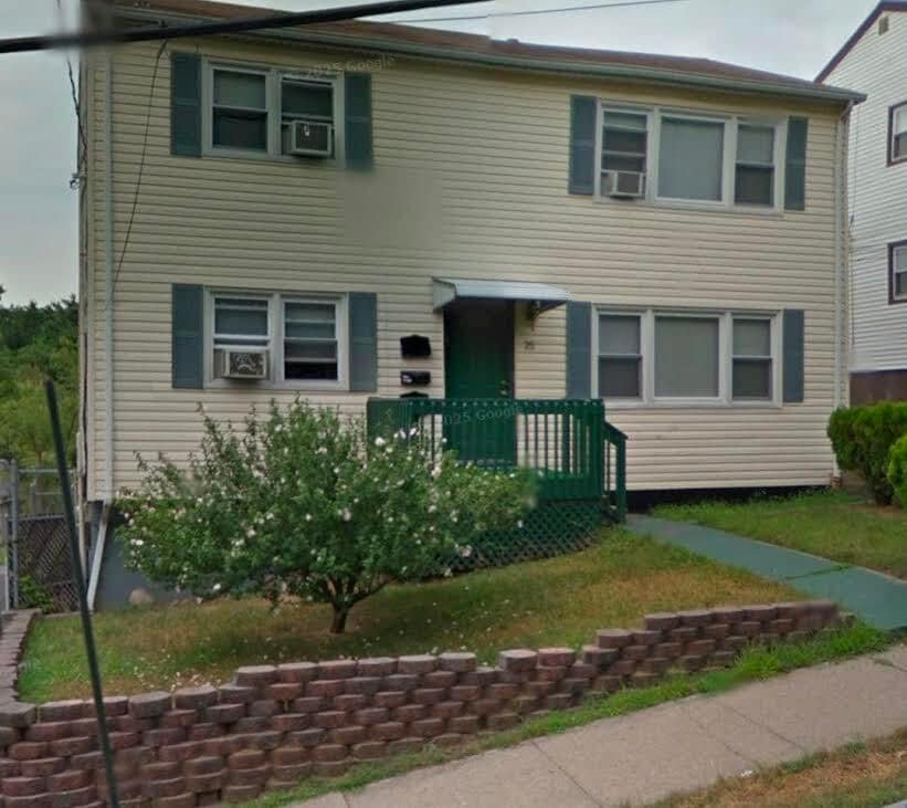
25 Oxford St
Paterson, NJ 07522
1 Day Ago
|
Edit
Favorites
862-319-8024
-
Bedrooms
3
-
Bathrooms
1
-
Square Feet
900 sq ft
-
Available
Available Apr 15
25 Oxford St

Favorites
About This Home
12 Month Lease,
$3,150 deposit,
Available Apr 15
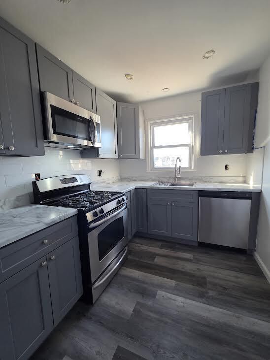
upgraded three bedrooms(large) 1bath available for rent.
3 Large bedroom 1 bath 2nd floor unit available for rent.
25 Oxford St is an apartment community located in Passaic County and the 07522 ZIP Code. This area is served by the Paterson Public School District attendance zone.
* Price shown is total price based on community-supplied monthly required fees. Excludes user-selected optional fees and variable or usage-based fees and required charges due at or prior to move-in or at move-out. Price, availability, fees, and any applicable rent special are subject to change without notice.
* Square footage definitions vary. Displayed square footage is approximate.
Fees and Policies
The fees listed below are community-provided and may exclude utilities or add-ons. All payments are made directly to the property and are non-refundable unless otherwise specified.
- One-Time Move-In Fees
-
Broker Fee$0
- Parking
-
Street--
Details
Utilities Included
-
Water
-
Sewer
Property Information
-
2 units
Contact
- Phone Number
Location
Get Directions
Paterson sits along the Passaic River just 15 miles from Midtown Manhattan, carrying the weight of genuine American industrial history in nearly every block. As the county seat of Passaic County and New Jersey's third-most populous city, it packs a remarkable amount of character into roughly nine square miles. The Great Falls of the Passaic River, now a National Historical Park, served as the original power source that made Paterson one of the country's first planned industrial cities, earning it the nickname Silk City for its once-dominant role in silk production. William Paterson University adds an academic presence to the broader area, drawing students and staff who contribute to the city's steady, grounded energy.
Neighborhoods here each carry their own personality. Downtown Paterson blends Beaux-Arts architecture with the Center City commercial district, while the Eastside Park Historic District offers tree-lined streets surrounding a 66-acre park.
Learn more about living in Paterson
Education
| Colleges & Universities | Distance | ||
|---|---|---|---|
| Colleges & Universities | Distance | ||
| Walk: | 14 min | 0.8 mi | |
| Drive: | 6 min | 2.4 mi | |
| Drive: | 6 min | 2.5 mi | |
| Drive: | 9 min | 5.1 mi |
25 Oxford St is within 14 minutes or 0.8 mile from Passaic County C.C., Paterson. It is also near Berkeley College and William Paterson University.
Schools

Public Elementary School
Grades K-5
248 Students
Nearby
Public High School
Grades 9-12
37 Students
Nearby
School data provided by
 The GreatSchools Rating helps parents compare schools within a state based on a variety of school quality indicators and provides a helpful picture of how effectively each school serves all of its students. Ratings are on a scale of 1 (below average) to 10 (above average) and can include test scores, college readiness, academic progress, advanced courses, equity, discipline and attendance data. We also advise parents to visit schools, consider other information on school performance and programs, and consider family needs as part of the school selection process.
View GreatSchools Rating Methodology
Data provided by GreatSchools.org © 2026. All rights reserved.
View GreatSchools Rating Methodology
Data provided by GreatSchools.org © 2026. All rights reserved.
Transportation options available in Paterson include Grove Street, located 11.0 miles from 25 Oxford St. 25 Oxford St is near Newark Liberty International, located 21.6 miles or 26 minutes away, and LaGuardia, located 26.1 miles or 38 minutes away.
| Transit / Subway | Distance | ||
|---|---|---|---|
| Transit / Subway | Distance | ||
|
|
Drive: | 16 min | 11.0 mi |
|
|
Drive: | 17 min | 11.3 mi |
|
|
Drive: | 17 min | 11.4 mi |
| Commuter Rail | Distance | ||
|---|---|---|---|
| Commuter Rail | Distance | ||
|
|
Walk: | 19 min | 1.0 mi |
|
|
Drive: | 5 min | 2.4 mi |
|
|
Drive: | 7 min | 3.9 mi |
|
|
Drive: | 8 min | 4.4 mi |
|
|
Drive: | 9 min | 4.5 mi |
| Airports | Distance | ||
|---|---|---|---|
| Airports | Distance | ||
|
Newark Liberty International
|
Drive: | 26 min | 21.6 mi |
|
LaGuardia
|
Drive: | 38 min | 26.1 mi |
Getting Around
 What do Walkability, Transit, Drivability, and Bikeability mean?
Walkability measures the walking distance to day-to-day needs.
Transit measures access to public transportation.
Drivability measures congestion, parking availability, and access to major roads.
Bikeability measures the suitability for cycling.
How It Works
What do Walkability, Transit, Drivability, and Bikeability mean?
Walkability measures the walking distance to day-to-day needs.
Transit measures access to public transportation.
Drivability measures congestion, parking availability, and access to major roads.
Bikeability measures the suitability for cycling.
How It Works
Exceptionally Walkable
Walkability
90
/ 100
Some Public Transit
Transit
50
/ 100
Fairly Drivable
Drivability
50
/ 100
Fairly Bikeable
Bikeability
50
/ 100
Scores provided by
-
Soundscore™
-
/ 100
Traffic
-Airport
-Businesses
-Scores provided by
HowLoud What is a Sound Score Rating? A Sound Score Rating aggregates noise caused by vehicle traffic, airplane traffic and local sources. How It WorksTime and distance from 25 Oxford St.
| Shopping Centers | Distance | ||
|---|---|---|---|
| Shopping Centers | Distance | ||
| Walk: | 2 min | 0.1 mi | |
| Drive: | 3 min | 1.8 mi | |
| Drive: | 4 min | 1.9 mi |
25 Oxford St has 3 shopping centers within 1.9 miles, which is about a 4-minute drive. The miles and minutes will be for the farthest away property.
| Parks and Recreation | Distance | ||
|---|---|---|---|
| Parks and Recreation | Distance | ||
|
Rifle Camp Park Observatory
|
Drive: | 5 min | 2.9 mi |
|
NJ Audubon Lorrimer Sanctuary
|
Drive: | 9 min | 5.1 mi |
|
Presby Memorial Iris Gardens
|
Drive: | 10 min | 6.1 mi |
|
McFaul Environmental Center
|
Drive: | 19 min | 8.2 mi |
|
Saddle River County Park
|
Drive: | 18 min | 8.8 mi |
25 Oxford St has 5 parks within 8.8 miles, including Rifle Camp Park Observatory, NJ Audubon Lorrimer Sanctuary, and Presby Memorial Iris Gardens.
| Hospitals | Distance | ||
|---|---|---|---|
| Hospitals | Distance | ||
| Drive: | 3 min | 1.7 mi | |
| Drive: | 9 min | 5.1 mi | |
| Drive: | 10 min | 5.9 mi |
25 Oxford St has 3 hospitals within 5.9 miles, the nearest is St. Joseph's Hospital and Medical Center which is 1.7 miles away and a 3 minute drive.
| Military Bases | Distance | ||
|---|---|---|---|
| Military Bases | Distance | ||
| Drive: | 35 min | 23.8 mi | |
| Drive: | 34 min | 24.1 mi |
25 Oxford St is 23.8 miles from Governors Island Support Center, and is convenient to other military bases, including Military Ocean Terminal.
25 Oxford St Photos
How do I access Social Services in New Jersey?
Statewide service is free, confidential, multilingual and always open. Three easy ways to reach Social Services in NJ: Dial 2-1-1; text your zip code to 898-211; or chat at https://www.nj211.org
What Are Walk Score®, Transit Score®, and Bike Score® Ratings?
Walk Score® measures the walkability of any address. Transit Score® measures access to public transit. Bike Score® measures the bikeability of any address.
What is a Sound Score Rating?
A Sound Score Rating aggregates noise caused by vehicle traffic, airplane traffic and local sources.

25 Oxford St
Paterson, NJ 07522