
The Station Apartments
5959 Broadway,
Bronx, NY 10463
$1,750 - $2,300
Studio - 1 Bed
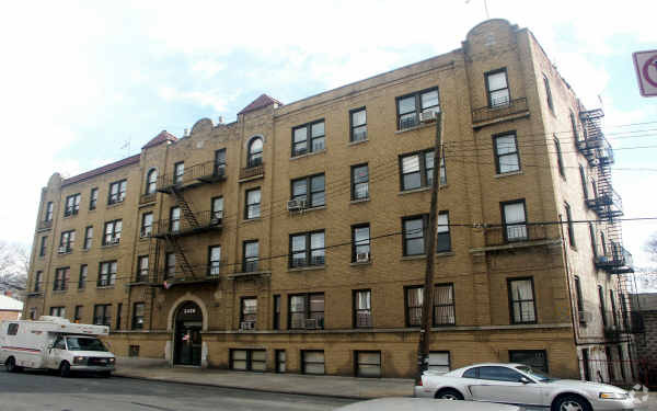
Explore your new place at 2430 Tratman Ave. With a location on Tratman Ave in Bronx's 10461 Zip code, local residents can easily connect with a number of entertainment options found in the surrounding area. Make a visit to check out the apartment floorplan options. The professional leasing staff is ready and waiting for you to come by to check us out. Contact us or stop by today.
2430 Tratman Ave is an apartment community located in Bronx County and the 10461 ZIP Code. This area is served by the New York City Geographic District #11 attendance zone.
Located 10 miles north of midtown Manhattan, Westchester Village feels like an urban hamlet updated for the 21st century. The Bronx neighborhood began as an English village in 1654, and several homes here date back to that era, a rarity in the Bronx. The original village green now serves as a pocket park and subway station, but locals still refer to the shop-lined intersection of Williamsbridge Road and East Tremont Avenue as "the Square." Here, visitors find the area's best eats, including Estrellita Poblana, a beloved Mexican restaurant known for its fresh guacamole.
Westchester Village attracts families looking for quiet streets and affordable apartments. Children love the Pearly Gates Playground, a public park located on St. Peters Avenue where kids go to slide, swing, or shoot hoops. The neighborhood offers culture as well. The Bronx Academy of Arts and Dance, known as BAAD!, converted a historic Gothic church into a theater for funky and ground-breaking productions.
Learn more about living in Westchester SquareCompare neighborhood and city base rent averages by bedroom.
| Westchester Square | Bronx, NY | |
|---|---|---|
| Studio | $1,108 | $1,628 |
| 1 Bedroom | $1,222 | $1,632 |
| 2 Bedrooms | $1,869 | $2,099 |
| 3 Bedrooms | - | $2,368 |
| Colleges & Universities | Distance | ||
|---|---|---|---|
| Colleges & Universities | Distance | ||
| Drive: | 3 min | 1.4 mi | |
| Drive: | 11 min | 4.5 mi | |
| Drive: | 10 min | 5.4 mi | |
| Drive: | 12 min | 6.2 mi |


Transportation options available in Bronx include Zerega Avenue, located 0.1 mile from 2430 Tratman Ave. 2430 Tratman Ave is near LaGuardia, located 8.6 miles or 17 minutes away, and John F Kennedy International, located 16.2 miles or 24 minutes away.
| Transit / Subway | Distance | ||
|---|---|---|---|
| Transit / Subway | Distance | ||
|
|
Walk: | 2 min | 0.1 mi |
|
|
Walk: | 5 min | 0.3 mi |
|
|
Walk: | 9 min | 0.5 mi |
|
|
Walk: | 14 min | 0.7 mi |
|
|
Drive: | 6 min | 2.4 mi |
| Commuter Rail | Distance | ||
|---|---|---|---|
| Commuter Rail | Distance | ||
|
|
Drive: | 7 min | 3.6 mi |
|
|
Drive: | 10 min | 3.8 mi |
|
|
Drive: | 9 min | 4.1 mi |
|
|
Drive: | 9 min | 4.6 mi |
|
|
Drive: | 10 min | 4.9 mi |
| Airports | Distance | ||
|---|---|---|---|
| Airports | Distance | ||
|
LaGuardia
|
Drive: | 17 min | 8.6 mi |
|
John F Kennedy International
|
Drive: | 24 min | 16.2 mi |
Scores provided by
Traffic
-Airport
-Businesses
-Scores provided by
HowLoud What is a Sound Score Rating? A Sound Score Rating aggregates noise caused by vehicle traffic, airplane traffic and local sources. How It WorksTime and distance from 2430 Tratman Ave.
| Shopping Centers | Distance | ||
|---|---|---|---|
| Shopping Centers | Distance | ||
| Drive: | 4 min | 1.2 mi | |
| Drive: | 3 min | 1.2 mi | |
| Drive: | 3 min | 1.3 mi |
| Parks and Recreation | Distance | ||
|---|---|---|---|
| Parks and Recreation | Distance | ||
|
Bronx Zoo
|
Drive: | 7 min | 2.6 mi |
|
Soundview Park
|
Drive: | 6 min | 2.6 mi |
|
Starlight Park
|
Drive: | 6 min | 2.8 mi |
|
Ferry Point Park
|
Drive: | 9 min | 3.3 mi |
|
Bronx Park
|
Drive: | 14 min | 4.9 mi |
| Hospitals | Distance | ||
|---|---|---|---|
| Hospitals | Distance | ||
| Walk: | 16 min | 0.8 mi | |
| Drive: | 5 min | 2.1 mi | |
| Drive: | 9 min | 4.2 mi |
| Military Bases | Distance | ||
|---|---|---|---|
| Military Bases | Distance | ||
| Drive: | 14 min | 6.6 mi | |
| Drive: | 33 min | 16.9 mi |
What Are Walk Score®, Transit Score®, and Bike Score® Ratings?
Walk Score® measures the walkability of any address. Transit Score® measures access to public transit. Bike Score® measures the bikeability of any address.
What is a Sound Score Rating?
A Sound Score Rating aggregates noise caused by vehicle traffic, airplane traffic and local sources.


