$2,295 / Month
2417 High Brandy Way
Odenton, MD 21113
2 Weeks Ago
Favorites
2417 High Brandy Way

Favorites
Check Back Soon for Upcoming Availability
| Beds | Baths | Average SF |
|---|---|---|
| 2 Bedrooms 2 Bedrooms 2 Br | 3 Baths 3 Baths 3 Ba | — |
About This Property
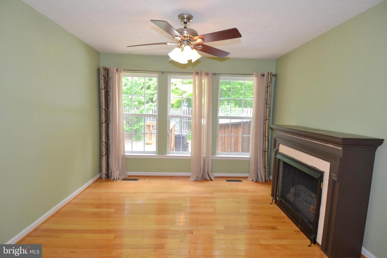
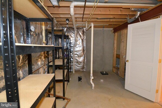
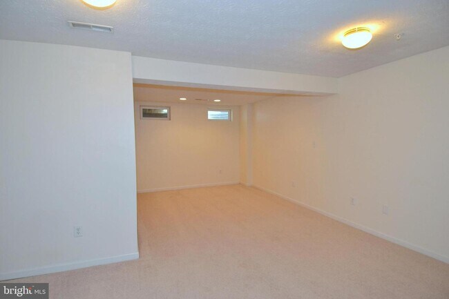
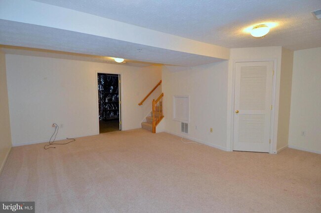
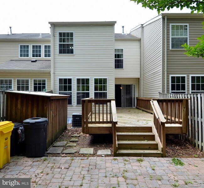
This spacious townhouse offers the rear room bump out on ALL 3 LEVELS. You will find hardwood flooring throughout the main level plus a big living area, kitchen w/island, sunroom & breakfast area. Upstairs offers dual master suites with vaulted ceilings, including one private bath w/jetted soaking tub! The finished basement offers a huge recreation room with space for an office or guest area, and a separate storage room! Privacy fenced backyard w/patio & rear deck! Short drive to Odenton MARC Station, NSA & Fort Meade! Close to all major roadways, plus plenty of shopping, restaurants & entertainment! Piney Orchard features multiple amenities including three outdoor pools, a Community Center with exercise room & indoor lap pool, lake with walking paths, Nature Preserve with trails, multiple playgrounds and MUCH MORE!
2417 High Brandy Way is a townhome located in Anne Arundel County and the 21113 ZIP Code. This area is served by the Anne Arundel County Public Schools attendance zone.
Townhome Features
- Dishwasher
- Basement
Location
Get Directions
Situated in Anne Arundel County, Odenton is centrally located between Annapolis, Washington D.C., and Baltimore. The city is continuously growing in population, largely due to its proximity to Fort George G. Meade military base and the developing Piney Orchard neighborhood.
In Odenton, you’ll discover a lot of great shopping centers like Waugh Chapel Towne Centre. Hikers will enjoy the plethora of trails that reside within the community, including Little Patuxent River Trail, Wild Turkey Way, and Merganser Pond Trail, among others. Midland Park is a large green space just minutes from Bowie State University. This Baltimore suburb contains highly rated public schools, plus access to Interstate 97 and Odenton Station.
Learn more about living in Odenton
Amenities
- Dishwasher
- Basement
Education
| Colleges & Universities | Distance | ||
|---|---|---|---|
| Colleges & Universities | Distance | ||
| Drive: | 24 min | 11.9 mi | |
| Drive: | 27 min | 15.0 mi | |
| Drive: | 30 min | 18.1 mi | |
| Drive: | 32 min | 20.3 mi |
2417 High Brandy Way is within 24 minutes or 11.9 miles from Bowie State University. It is also near Anne Arundel Community College and United States Naval Academy.
Schools

Public Elementary School
Grades PK-5
671 Students
Attendance Zone
Public Middle School
Grades 6-8
1,286 Students
Attendance Zone
Public High School
Grades 9-12
1,617 Students
Attendance Zone
Private Elementary, Middle & High School
Grades PK-12
181 Students
Nearby
Private Elementary & Middle School
Grades PK-8
736 Students
Nearby
School data provided by
 The GreatSchools Rating helps parents compare schools within a state based on a variety of school quality indicators and provides a helpful picture of how effectively each school serves all of its students. Ratings are on a scale of 1 (below average) to 10 (above average) and can include test scores, college readiness, academic progress, advanced courses, equity, discipline and attendance data. We also advise parents to visit schools, consider other information on school performance and programs, and consider family needs as part of the school selection process.
View GreatSchools Rating Methodology
Data provided by GreatSchools.org © 2025. All rights reserved.
View GreatSchools Rating Methodology
Data provided by GreatSchools.org © 2025. All rights reserved.
Transportation options available in Odenton include Bwi Business District, located 11.1 miles from 2417 High Brandy Way. 2417 High Brandy Way is near Baltimore/Washington International Thurgood Marshall, located 11.2 miles or 21 minutes away, and Ronald Reagan Washington Ntl, located 32.3 miles or 49 minutes away.
| Transit / Subway | Distance | ||
|---|---|---|---|
| Transit / Subway | Distance | ||
|
|
Drive: | 21 min | 11.1 mi |
|
|
Drive: | 22 min | 11.5 mi |
|
|
Drive: | 21 min | 11.6 mi |
|
|
Drive: | 21 min | 11.8 mi |
|
|
Drive: | 21 min | 12.1 mi |
| Commuter Rail | Distance | ||
|---|---|---|---|
| Commuter Rail | Distance | ||
|
|
Drive: | 6 min | 2.9 mi |
|
|
Drive: | 19 min | 9.3 mi |
|
|
Drive: | 19 min | 10.8 mi |
|
Bowie State Marc Nb
|
Drive: | 24 min | 11.9 mi |
|
Bowie State Marc Sb
|
Drive: | 23 min | 13.3 mi |
| Airports | Distance | ||
|---|---|---|---|
| Airports | Distance | ||
|
Baltimore/Washington International Thurgood Marshall
|
Drive: | 21 min | 11.2 mi |
|
Ronald Reagan Washington Ntl
|
Drive: | 49 min | 32.3 mi |
Time and distance from 2417 High Brandy Way.
| Shopping Centers | Distance | ||
|---|---|---|---|
| Shopping Centers | Distance | ||
| Drive: | 5 min | 2.1 mi | |
| Drive: | 6 min | 2.7 mi | |
| Drive: | 8 min | 3.5 mi |
2417 High Brandy Way has 3 shopping centers within 3.5 miles, which is about a 8-minute drive. The miles and minutes will be for the farthest away property.
| Parks and Recreation | Distance | ||
|---|---|---|---|
| Parks and Recreation | Distance | ||
|
Patuxent Research Refuge - North Tract
|
Drive: | 17 min | 8.5 mi |
|
Kinder Farm Park
|
Drive: | 22 min | 11.3 mi |
|
Howard Owens Science Center
|
Drive: | 28 min | 15.8 mi |
|
NASA Goddard Space Flight Center
|
Drive: | 30 min | 16.7 mi |
|
Patuxent Research Refuge - South Tract
|
Drive: | 31 min | 16.7 mi |
2417 High Brandy Way has 5 parks within 16.7 miles, including Patuxent Research Refuge - North Tract, Kinder Farm Park, and Howard Owens Science Center.
| Hospitals | Distance | ||
|---|---|---|---|
| Hospitals | Distance | ||
| Drive: | 20 min | 11.7 mi | |
| Drive: | 28 min | 14.5 mi |
2417 High Brandy Way is 11.7 miles from University of Maryland Baltimore Washington Medical Center, and is convenient to other hospitals, including Laurel Regional Medical Center.
| Military Bases | Distance | ||
|---|---|---|---|
| Military Bases | Distance | ||
| Drive: | 13 min | 6.2 mi |
2417 High Brandy Way is 6.2 miles and a 13 minute drive from Fort George Meade.
You May Also Like
Similar Rentals Nearby


What Are Walk Score®, Transit Score®, and Bike Score® Ratings?
Walk Score® measures the walkability of any address. Transit Score® measures access to public transit. Bike Score® measures the bikeability of any address.
What is a Sound Score Rating?
A Sound Score Rating aggregates noise caused by vehicle traffic, airplane traffic and local sources

2417 High Brandy Way
Odenton, MD 21113