


$3,550
/ Month
241 Ferry Landing Cir
Portsmouth, RI 02871
2 Weeks Ago
|
Edit
Favorites
241 Ferry Landing Cir

Favorites
Check Back Soon for Upcoming Availability
| Beds | Baths | Average SF |
|---|---|---|
| 2 Bedrooms 2 Bedrooms 2 Br | 2.1 Baths 2.1 Baths 2.1 Ba | 2,434 SF |
Fees and Policies
The fees listed below are community-provided and may exclude utilities or add-ons. All payments are made directly to the property and are non-refundable unless otherwise specified.
About This Property
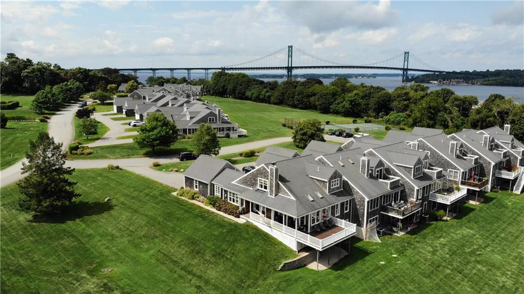
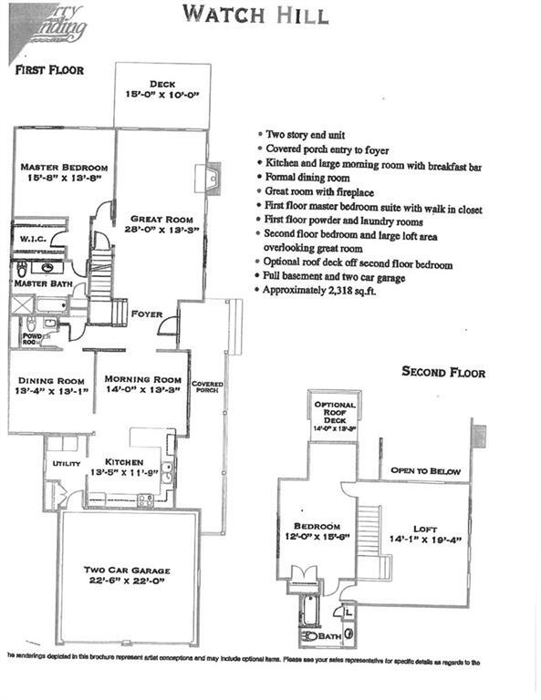
Coastal Shingle Style Townhome sited on what was a nine hole golf course. Mature trees, open area and a pickleball court. Upscale casual living just a stroll away from a waterfront park under the Mount Hope Bridge. Open floor plan featuring a cooks kitchen,formal dining,open vaulted fireplaced living room with sliders to a bridge view deck. First floor primary ensuite with tub and shower. Second floor bedroom suite with open loft area for an office or overflow guests.Easy commute to Providence or Boston. Five minutes to downtown Bristol for shopping and dining.
241 Ferry Landing Cir is a condo located in Newport County and the 02871 ZIP Code. This area is served by the Portsmouth School District attendance zone.
Condo Features
Air Conditioning
Dishwasher
Hardwood Floors
Microwave
- Air Conditioning
- Security System
- Fireplace
- Dishwasher
- Microwave
- Range
- Refrigerator
- Hardwood Floors
- Carpet
- Tile Floors
- Attic
- Views
- Pool
- Tennis Court
- Waterfront
- Balcony
- Porch
- Deck
241 Ferry Landing Cir,
Portsmouth,
RI
02871
Portsmouth sits on the northern end of Aquidneck Island in Newport County, sharing that landmass with Middletown and the well-known city of Newport to the south. As the second-oldest municipality in Rhode Island, it carries genuine historical weight — the town was one of four original settlements that formed the Colony of Rhode Island and Providence Plantations in the 17th century. Today it operates as a quiet, coastal community spread across roughly 39 square miles of land, with Narragansett Bay defining much of its character and geography.
Life here moves at a measured pace. Residents have easy access to the energy of Newport without being absorbed by it, and Providence sits within about 30 miles to the northwest. The housing mix reflects the town's suburban scale — single-family homes dominate, but apartment communities and smaller multi-unit rentals provide options for those seeking lower-maintenance living.
Learn more about living in Portsmouth
Amenities
- Air Conditioning
- Security System
- Fireplace
- Dishwasher
- Microwave
- Range
- Refrigerator
- Hardwood Floors
- Carpet
- Tile Floors
- Attic
- Views
- Waterfront
- Balcony
- Porch
- Deck
- Pool
- Tennis Court
Education
| Colleges & Universities | Distance | ||
|---|---|---|---|
| Colleges & Universities | Distance | ||
| Drive: | 5 min | 2.0 mi | |
| Drive: | 21 min | 10.0 mi | |
| Drive: | 23 min | 12.5 mi | |
| Drive: | 30 min | 13.8 mi |
241 Ferry Landing Cir is within 5 minutes or 2.0 miles from Roger Williams University. It is also near C.C. of Rhode Island, Newport and Bristol Community College.
Schools


Public Elementary School
Grades PK-5
342 Students
Nearby
Public Elementary & Middle School
Grades K-8
616 Students
Attendance Zone
Public Elementary School
Grades K-5
426 Students
Attendance Zone
Public High School
Grades 9-12
803 Students
Attendance Zone
Private Elementary & Middle School
Grades PK-8
154 Students
Nearby
Private High School
Grades 9-12
334 Students
Nearby
School data provided by
 The GreatSchools Rating helps parents compare schools within a state based on a variety of school quality indicators and provides a helpful picture of how effectively each school serves all of its students. Ratings are on a scale of 1 (below average) to 10 (above average) and can include test scores, college readiness, academic progress, advanced courses, equity, discipline and attendance data. We also advise parents to visit schools, consider other information on school performance and programs, and consider family needs as part of the school selection process.
View GreatSchools Rating Methodology
Data provided by GreatSchools.org © 2026. All rights reserved.
View GreatSchools Rating Methodology
Data provided by GreatSchools.org © 2026. All rights reserved.
Walkability Near 241 Ferry Landing Cir Portsmouth, RI 02871
Getting Around
 What do Walkability, Transit, Drivability, and Bikeability mean?
Walkability measures the walking distance to day-to-day needs.
Transit measures access to public transportation.
Drivability measures congestion, parking availability, and access to major roads.
Bikeability measures the suitability for cycling.
How It Works
What do Walkability, Transit, Drivability, and Bikeability mean?
Walkability measures the walking distance to day-to-day needs.
Transit measures access to public transportation.
Drivability measures congestion, parking availability, and access to major roads.
Bikeability measures the suitability for cycling.
How It Works
Somewhat Walkable
Walkability
20
/ 100
Limited Public Transit
Transit
20
/ 100
Exceptionally Drivable
Drivability
100
/ 100
Somewhat Bikeable
Bikeability
30
/ 100
Scores provided by
Calm
Soundscore™
84
/ 100
Traffic
CalmAirport
CalmBusinesses
CalmScores provided by
HowLoud What is a Sound Score Rating? A Sound Score Rating aggregates noise caused by vehicle traffic, airplane traffic and local sources. How It WorksYou May Also Like
Similar Rentals Nearby


What Are Walk Score®, Transit Score®, and Bike Score® Ratings?
Walk Score® measures the walkability of any address. Transit Score® measures access to public transit. Bike Score® measures the bikeability of any address.
What is a Sound Score Rating?
A Sound Score Rating aggregates noise caused by vehicle traffic, airplane traffic and local sources.

241 Ferry Landing Cir
Portsmouth, RI 02871