

$850
/ Month
23628 Highway U
Crocker, MO 65452
2 Weeks Ago
|
Edit
Favorites
23628 Highway U

Favorites
Check Back Soon for Upcoming Availability
| Beds | Baths | Average SF |
|---|---|---|
| 3 Bedrooms 3 Bedrooms 3 Br | 1 Bath 1 Bath 1 Ba | — |
About This Property
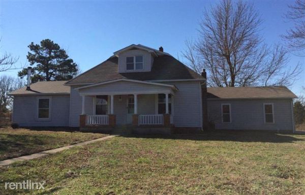
(573) 336-3535 - !! Virtual Tour Coming Soon !! This 3 bedroom, 1.5 bath home has a fenced backyard and a wood burning stove. The kitchen comes equipped with a refrigerator, stove, and dishwasher. This home sits in a wonderful country setting with plenty of open space for your enjoyment. Approximately 9 acres and a barn are also available for your use. (RLNE2036510) Other Amenities - Other- Fenced Back Yard, Smoke Free, Garage- 2 Car Gargae. Appliances - Dishwasher, Refrigerator, Range, Oven, Washer & Dryer Hookup, Other- Wood Burning Stove. Lease lengths - Other- Negotiable. Pet policies - Other- Small Pet Friendly. $35.00 monthly rent increase per pet..
23628 Highway U is a house located in Pulaski County and the 65452 ZIP Code. This area is served by the Crocker R-Ii School District attendance zone.
23628 Highway U,
Crocker,
MO
65452
Education
| Colleges & Universities | Distance | ||
|---|---|---|---|
| Colleges & Universities | Distance | ||
| Drive: | 53 min | 40.4 mi |
23628 Highway U is within 53 minutes or 40.4 miles from Missouri Univ. of Sci. &Tech..
Schools


Public Elementary School
Grades PK-5
Attendance Zone
Public Middle & High School
Grades 6-12
Attendance Zone
Private Elementary, Middle & High School
Grades PK-12
Nearby
Private Elementary, Middle & High School
Grades PK-12
Nearby
Private Elementary & High School
Grades K-5 & 9-12
Nearby
School data provided by
 The GreatSchools Rating helps parents compare schools within a state based on a variety of school quality indicators and provides a helpful picture of how effectively each school serves all of its students. Ratings are on a scale of 1 (below average) to 10 (above average) and can include test scores, college readiness, academic progress, advanced courses, equity, discipline and attendance data. We also advise parents to visit schools, consider other information on school performance and programs, and consider family needs as part of the school selection process.
View GreatSchools Rating Methodology
Data provided by GreatSchools.org © 2026. All rights reserved.
View GreatSchools Rating Methodology
Data provided by GreatSchools.org © 2026. All rights reserved.
Walkability Near 23628 Highway U Crocker, MO 65452
Getting Around
 What do Walkability, Transit, Drivability, and Bikeability mean?
Walkability measures the walking distance to day-to-day needs.
Transit measures access to public transportation.
Drivability measures congestion, parking availability, and access to major roads.
Bikeability measures the suitability for cycling.
How It Works
What do Walkability, Transit, Drivability, and Bikeability mean?
Walkability measures the walking distance to day-to-day needs.
Transit measures access to public transportation.
Drivability measures congestion, parking availability, and access to major roads.
Bikeability measures the suitability for cycling.
How It Works
Somewhat Walkable
Walkability
20
/ 100
Exceptionally Drivable
Drivability
100
/ 100
Somewhat Bikeable
Bikeability
20
/ 100
Scores provided by
-
Soundscore™
-
/ 100
Traffic
-Airport
-Businesses
-Scores provided by
HowLoud What is a Sound Score Rating? A Sound Score Rating aggregates noise caused by vehicle traffic, airplane traffic and local sources. How It WorksYou May Also Like
Similar Rentals Nearby


What Are Walk Score®, Transit Score®, and Bike Score® Ratings?
Walk Score® measures the walkability of any address. Transit Score® measures access to public transit. Bike Score® measures the bikeability of any address.
What is a Sound Score Rating?
A Sound Score Rating aggregates noise caused by vehicle traffic, airplane traffic and local sources.
23628 Highway U
Crocker, MO 65452